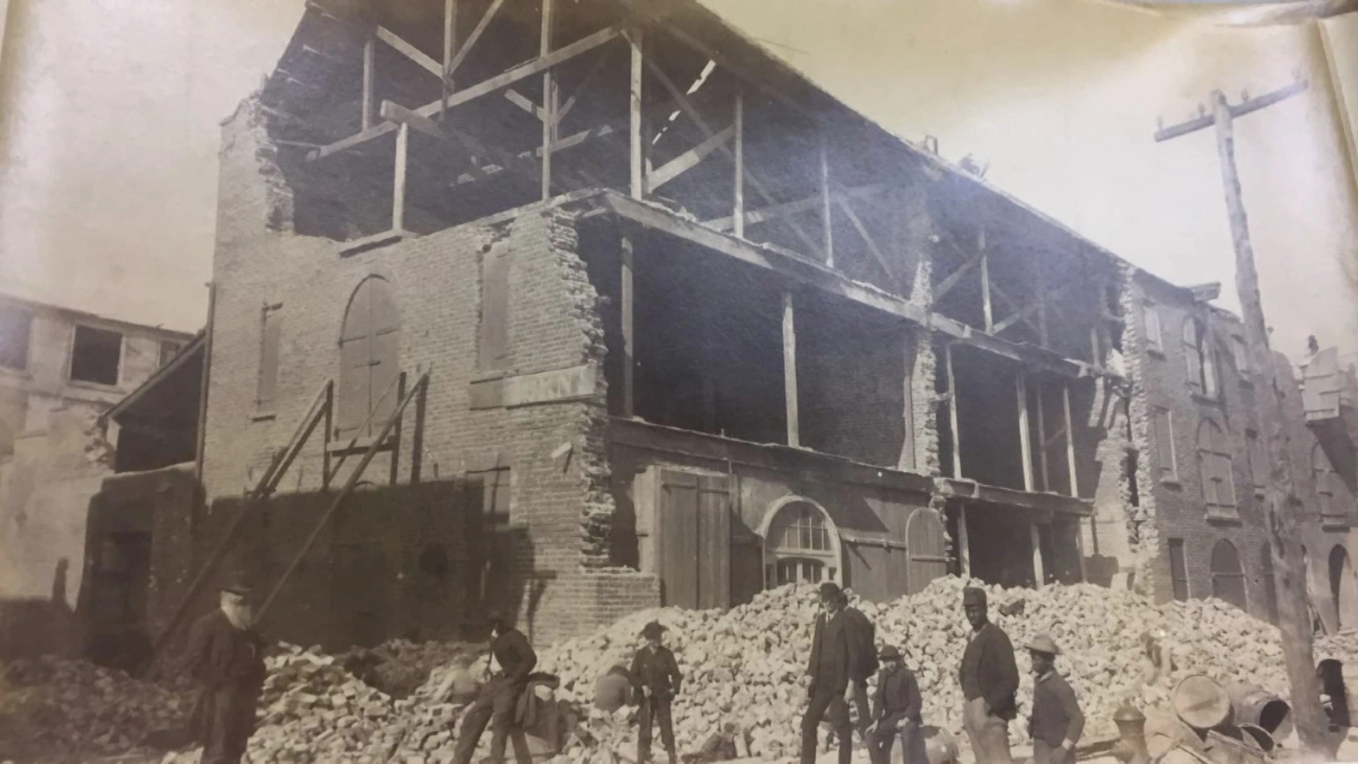
1886 Charleston Earthquake
At 9:50 on the evening of August 31, 1886, the ground beneath Charleston, South Carolina, began to move. Within seconds, brick walls cracked and collapsed, church steeples swayed and fell, and the streets filled with choking dust and the screams of residents who had never imagined that earthquakes happened here. The shaking lasted less than a minute, but in that span a magnitude 7.0 earthquake -- the most powerful ever recorded on the American East Coast -- killed approximately 60 people, damaged or destroyed 2,000 buildings, and severed Charleston from the outside world by snapping telegraph wires and twisting railroad tracks into useless ribbons of steel. The shock was felt from Boston to Cuba, from Chicago to Bermuda. Sand boils erupted from the liquefied ground. The damage reached $5 to $6 million, roughly $112 million in modern currency. Charleston, a city that had survived revolution, civil war, and bombardment, was brought to its knees by the earth itself.
Faults Older Than the Atlantic
Earthquakes are expected along the Pacific coast, where tectonic plates grind against each other in plain geological view. They are not expected in Charleston. The 1886 earthquake is classified as an intraplate event -- it occurred not at a plate boundary but deep within the North American plate itself, along faults that formed during the breakup of the supercontinent Pangaea roughly 200 million years ago. These ancient fractures run beneath the coastal plain sediments of the eastern seaboard, invisible and largely silent, reactivated by stresses within the plate that geologists are still working to fully understand. Researchers Roger Bilham and Susan Hough later studied railroad surveys from the 1880s and 1910s and discovered that the earthquake produced measurable uplift at Summerville and a right-lateral offset along the tracks of the South Carolina Railroad -- physical proof of fault movement along what is now called the Summerville Fault. The discovery confirmed that even the most geologically quiet regions can harbor destructive forces.
When Brick Met Liquefied Ground
The destruction in Charleston followed a cruel logic. Eighty-one percent of building damage struck structures made of brick. Wood-frame buildings fared far better, though their survival also depended on what lay beneath them. Buildings on made ground -- filled land along the waterfront and marshes -- were dramatically more vulnerable. Among wood-frame structures, 14 percent of those on filled ground sustained damage compared to just 0.5 percent on solid ground. Commercial buildings suffered the worst: they tended to be older, taller relative to their foundations, and made of unreinforced masonry. Railroad tracks in and around Charleston snapped. Trains derailed. Dams broke, flooding farms and roads. The ground liquefied in spots across the Lowcountry, swallowing foundations and buckling streets. Sand boils -- geysers of water and sand forced upward through liquefied soil -- pockmarked the landscape for miles around the epicenter.
Cut Off and Shaken Again
The earthquake severed Charleston's telegraph lines and destroyed its rail connections, leaving the city isolated at the moment it most needed help. Major structural damage reached as far as Tybee Island, Georgia, more than 60 miles away, and was reported in central Alabama, central Ohio, eastern Kentucky, southern Virginia, and western West Virginia. The initial shock was only the beginning. Aftershocks began immediately and continued for decades -- 300 within the first 30 years, 435 in total. Minor seismic activity in the Charleston area continues into the present century, and some geologists believe these modern tremors may still be aftershocks of the 1886 event, echoes of a rupture that has not fully settled after more than a century.
Bolts Through the Walls
Charleston rebuilt with a quiet innovation that visitors notice on nearly every historic block downtown. After the earthquake, building owners installed earthquake bolts -- long iron rods threaded through the masonry walls of damaged structures, tying opposite walls together for stability. The circular iron plates visible on building exteriors throughout the historic district are the anchor points of these bolts, decorative only by accident. They were engineering solutions, cheaper than demolition and effective enough to keep unreinforced brick structures standing. Walk the streets south of Broad and you will see them everywhere -- small iron circles and stars and diamonds, flush against pastel stucco, marking the places where Charleston stitched itself back together. Local photographer George LaGrange Cook documented the devastation in a series of images published as Cook's Earthquake Views of Charleston and Vicinity, a collection now held by the Gibbes Museum of Art.
The Fault Beneath the Charm
Modern seismologists estimate that if an earthquake of the same magnitude struck Charleston today, it would cause approximately $20 billion in damage in South Carolina alone, along with an estimated 900 deaths and 44,000 injuries. The city has grown enormously since 1886, and much of that growth has occurred on the same filled ground and soft coastal sediments that amplified the original shaking. The South Carolina Emergency Management Division now plans for earthquake scenarios, and building codes have been updated, but the fundamental vulnerability remains: Charleston sits above ancient faults that rupture on cycles of 500 to 600 years, long enough for memory to fade and complacency to settle in. The earthquake bolts on the old buildings are reminders -- not just of what happened, but of what the ground beneath Charleston is still capable of doing.
From the Air
The 1886 earthquake epicenter was located near 32.90°N, 80.00°W, approximately 15 miles northwest of downtown Charleston near Summerville, South Carolina. From the air, the historic district of Charleston (visible on the peninsula between the Ashley and Cooper Rivers) contains buildings with earthquake bolt plates visible at low altitude. Charleston International Airport (KCHS) is approximately 12 miles north-northwest of downtown. Charleston Executive Airport (KJZI) is 8 miles southwest. The Summerville area, near the epicenter, is visible inland along the general path of the old South Carolina Railroad corridor. Best viewed at 1,000-3,000 feet over the historic district to appreciate the density of period architecture that survived the quake.