1886 eruption of Mount Tarawera
The evening of 9 June 1886 began unremarkably - a clear night over the Rotorua district, the kind of stillness that makes what follows feel like ambush. Shortly after midnight on the morning of 10 June, more than thirty earthquakes rolled through the region in rapid succession, each stronger than the last. By 1:30 a.m., explosions had begun. By 2:30 a.m., all three of Mount Tarawera's peaks were erupting simultaneously, hurling columns of smoke and ash thousands of metres into a sky split by volcanic lightning. A fissure eight kilometres long had ripped open the mountain, and it was still growing.
The Rift Tears Open
The eruption began at the Wahanga dome and propagated southwest at devastating speed. As the fissure extended, it carved a rift roughly 17 kilometres long - punching through the mountain, passing through Lake Rotomahana, and extending beyond into what would become the Waimangu valley. The dyke feeding the eruption trended at 57 degrees and the basaltic magma, already partially crystallised before reaching the surface, blasted new craters along the entire length of the rift. An eruption cloud rose 9.5 kilometres high. The surrounding landscape - forests of rimu, rātā, tōtara, and pōhutukawa that had stood for centuries - was shredded. Survivors later described the forest as "a mass of broken limbs and riven stumps, wrenched and torn to an extent that renders the wood utterly useless."
Villages in the Path
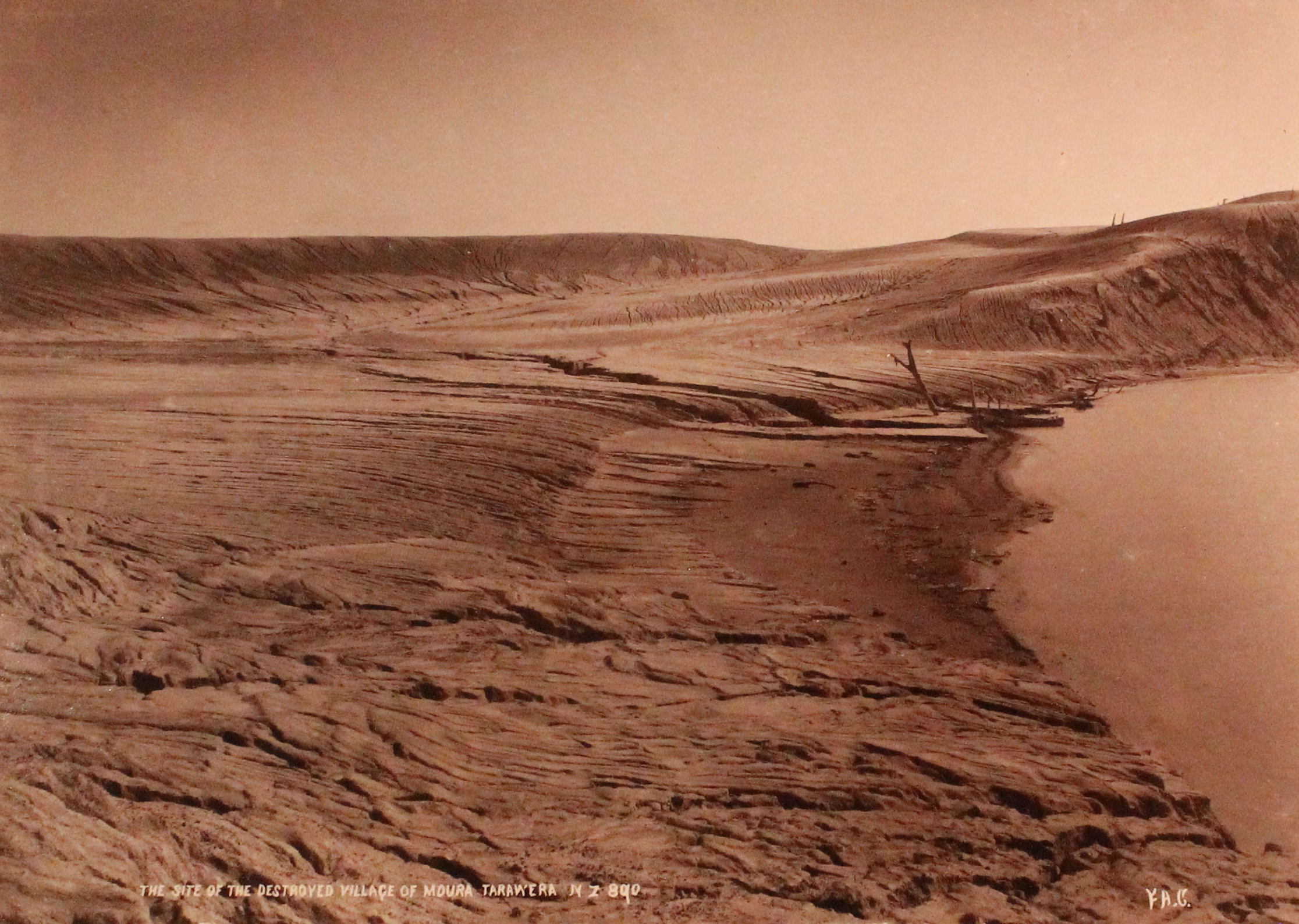
Search parties dispatched from Rotorua and ŌHinemutu at first light found a landscape unrecognizable. The settlements of Te Wairoa, Moura, Te Ariki, Te Tapahoro, Totaraiki, and Waingōngongo had been destroyed or buried. Around 120 people died, the overwhelming majority Māori living in villages within close range of the rift. A group of roughly twelve Māori from Te Ariki, who had been camping at the Pink Terraces on the night of the eruption, were never found. Among the survivors was Tūhoto, a tohunga discovered alive in his buried whare after four days. When rescuers pulled him from the ash, he demanded they leave him to die. Taken to a Rotorua sanitorium, he died two weeks later, having reportedly decided to stop living. Most survivors from Te Wairoa relocated to Whakarewarewa or Rotorua rather than rebuild on the devastated ground.
A Landscape Remade
The eruption reshaped the geography permanently. Massive ash deposits blocked the Kaiwaka Stream, which had previously drained Lake Rotomahana into Lake Tarawera. As the craters gradually refilled with water, the blockage caused Rotomahana to expand dramatically - rising 35 metres above its pre-eruption level and extending its depth to 75 metres below the old lake floor. The new lake swallowed the former site of Lake Rotomakariri and the surrounding terrain, becoming three times wider and longer than its predecessor. Somewhere beneath its waters or along its shores, the famed Pink and White Terraces - once called the Eighth Wonder of the World and New Zealand's greatest tourist attraction - lay buried or destroyed. Their fate sparked a debate that continues into the twenty-first century.
Echoes That Carry
The 1886 eruption was the largest in New Zealand in the past 500 years and was classified as a VEI-5 event - powerful enough to reshape a region but contained enough to spare the wider country. Its legacy shaped how New Zealand understood its volcanic risks. The eruption drove home a lesson the Māori communities already knew: the geothermal wonders that drew tourists to the region were surface expressions of forces capable of immense destruction. Today, the scarred summit of Tarawera is accessible by guided tour. The buried village of Te Wairoa has been partially excavated and serves as an open-air museum, its buildings still half-swallowed by the mud and ash that entombed them on that June night. The mountain stands quiet, but volcanologists note that quiet and extinct are not the same word.
From the Air
Located at 38.23°S, 176.51°E, Mount Tarawera is visible from altitude as a distinctive rift-scarred summit about 24 km southeast of Rotorua. The 17 km eruption rift running SW-NE across the summit and through Lake Rotomahana is clearly visible from the air - a dramatic gash through the landscape. Lake Rotomahana sits immediately to the SW. Nearest airports: NZRO (Rotorua, 24 km NW), NZAP (Taupō, 80 km SW). The Buried Village of Te Wairoa lies on the NW shore of Lake Tarawera.