The 1894 Tokyo Earthquake: A Rehearsal the City Forgot
At 2:04 in the afternoon on June 20, 1894, the ground beneath Tokyo Bay lurched. The magnitude 6.6 earthquake radiated outward from an epicenter in the bay itself, rattling downtown Tokyo and the neighboring cities of Kawasaki and Yokohama across Kanagawa Prefecture. Thirty-one people died. One hundred fifty-seven were injured. Buildings crumbled in Kyōbashi-ku, a tea house collapsed in Tsukiji, and the ground in the Mita district turned to liquid as the soil gave way beneath it. Then Tokyo rebuilt, as it always does, and largely forgot -- until a vastly more destructive earthquake arrived twenty-nine years later.
A Tremor from the Deep Pacific
The earthquake's exact depth has never been determined, but seismologists believe it originated within the subducting Pacific Plate beneath the Kanto region -- the same tectonic mechanism responsible for many of Japan's most devastating quakes. At magnitude 6.6 on the Richter scale, it was powerful enough to cause structural damage across a wide area but modest compared to what the same fault system would eventually unleash. The shaking was felt most intensely in downtown Tokyo and across the bay in Yokohama and Kawasaki. In the Mita neighborhood, soil liquefaction caused the ground to behave like water, swallowing foundations and buckling streets. Photographs taken in the immediate aftermath -- some of which survive today as albumen prints and dry plates at the National Science Museum of Japan -- show collapsed walls in Kyōbashi-ku and a destroyed tea house in Tsukiji, the fishing district that would later become home to the world's most famous fish market.
Through the Eyes of Writers
What makes the 1894 earthquake remarkable is not its magnitude but the literary record it left behind. Ichiyō Higuchi, one of the first major female writers in modern Japanese literature, documented the event in her diary-like work Mizu-no-ue no nikki. She described buildings damaged in Yotsuya and the eerie sight of soil liquefaction in Mita, where solid ground turned fluid. She also noted an aftershock that struck at ten o'clock that night, unsettling a city already on edge. Jun'ichirō Tanizaki, who would become one of the towering figures of twentieth-century Japanese fiction, was a small child in 1894. In his autobiographical work Yōshō-jidai, he described the terror of his family's house collapsing around him during the quake. The experience scarred him permanently -- Tanizaki attributed his lifelong phobia of earthquakes to that afternoon. Through Higuchi and Tanizaki, the 1894 earthquake persists not in seismological data but in Japanese literature.
Foreign Witnesses in Meiji Tokyo
By 1894, Tokyo and Yokohama had grown into cosmopolitan cities with sizable communities of foreign residents -- diplomats, merchants, teachers, and missionaries drawn to a Japan rapidly modernizing under the Meiji government. Many of these residents recorded the earthquake in letters, diaries, and dispatches home. Their accounts provide an outsider's perspective on a city caught between its feudal past and industrial future, where wooden machiya townhouses stood alongside newly constructed Western-style brick buildings. The earthquake tested both building traditions. The brick structures, modeled on European engineering that rarely accounted for seismic activity, proved particularly vulnerable. Japan was only beginning to develop the earthquake-resistant construction techniques that would eventually make its architecture among the most resilient in the world.
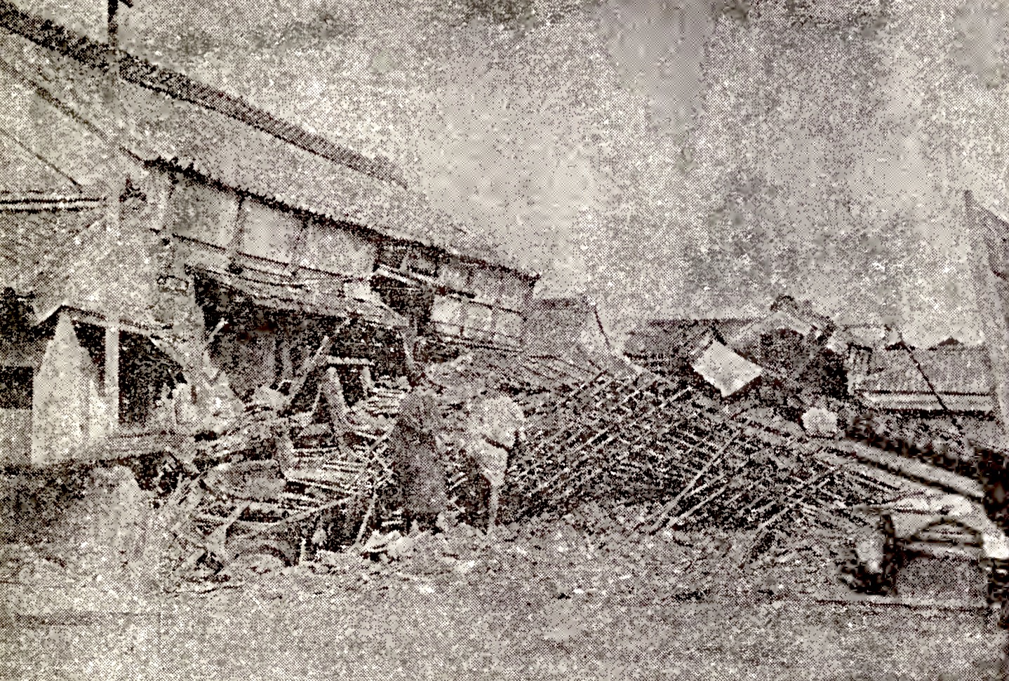
Photographs That Nearly Vanished
The 1894 earthquake arrived at a moment when photography was still a relatively new documentary tool in Japan. The Imperial Earthquake Investigation Committee -- one of the world's first government bodies dedicated to seismological research -- commissioned photographs immediately after the event for its official reports. These images, captured on dry plates and printed as albumen papers and lantern slides, recorded cracked walls, collapsed roofs, and the haunted faces of a shaken city. The National Science Museum of Japan in Tokyo preserves twenty-two of these photographs today. They are among the earliest photographic records of earthquake damage in Japan. Almost all of the original glass plates have been lost, making the surviving prints irreplaceable windows into a disaster that served as a grim dress rehearsal for the Great Kanto Earthquake of 1923, which would kill more than 100,000 people and reshape Tokyo entirely.
From the Air
The epicenter was located at approximately 35.70°N, 139.80°E in Tokyo Bay. From the air, Tokyo Bay is the dominant geographic feature -- a large, enclosed body of water bordered by Tokyo to the west, Yokohama and Kawasaki to the south, and Chiba to the east. The areas most affected -- Kyōbashi-ku, Tsukiji, Mita, and Yotsuya -- are in central Tokyo's Chiyoda and Minato wards, visible as dense urban blocks west of the bay. Best viewed at 3,000-5,000 feet AGL. Tokyo Haneda Airport (RJTT) lies on the western shore of the bay approximately 5 nautical miles south of the epicenter area.