1948 Fukui Earthquake
At 4:13 in the afternoon on June 28, 1948, many residents of Fukui were cooking dinner. The earthquake arrived without warning -- a magnitude 7.1 jolt from a fault no one knew existed, centered just 10 kilometers north-northeast of the city. Within seconds, 79 percent of the buildings in central Fukui collapsed. Cooking fires ignited the wreckage. The roads were destroyed, the waterworks shattered, and it took five days to extinguish the flames. When the fires finally died, 3,769 people were dead, 22,000 were wounded, and more than 36,000 buildings lay in ruins. Fukui had been nearly leveled by American air raids just three years earlier. Now, the earth itself had finished the job.
A City Already on Its Knees
The cruelest fact about the 1948 Fukui earthquake is its timing. In July 1945, American bombers had devastated the city in a series of air raids that left much of Fukui in rubble. Three years later, residents were still rebuilding -- erecting new homes and shops on the alluvial plain of the Fukui basin, hurrying to restore normalcy after the war. Many of these hastily constructed buildings proved fatally vulnerable to seismic shaking. The soft, waterlogged soil of the floodplain amplified the earthquake's force, and structures that had stood for only months pancaked in seconds. In the Kanazugocho district, in Maruoka and Harue, and throughout Yoshida District, nearly every building was leveled. The destruction rate across the entire Fukuiheiya floodplain exceeded 60 percent.
The Fault Nobody Knew
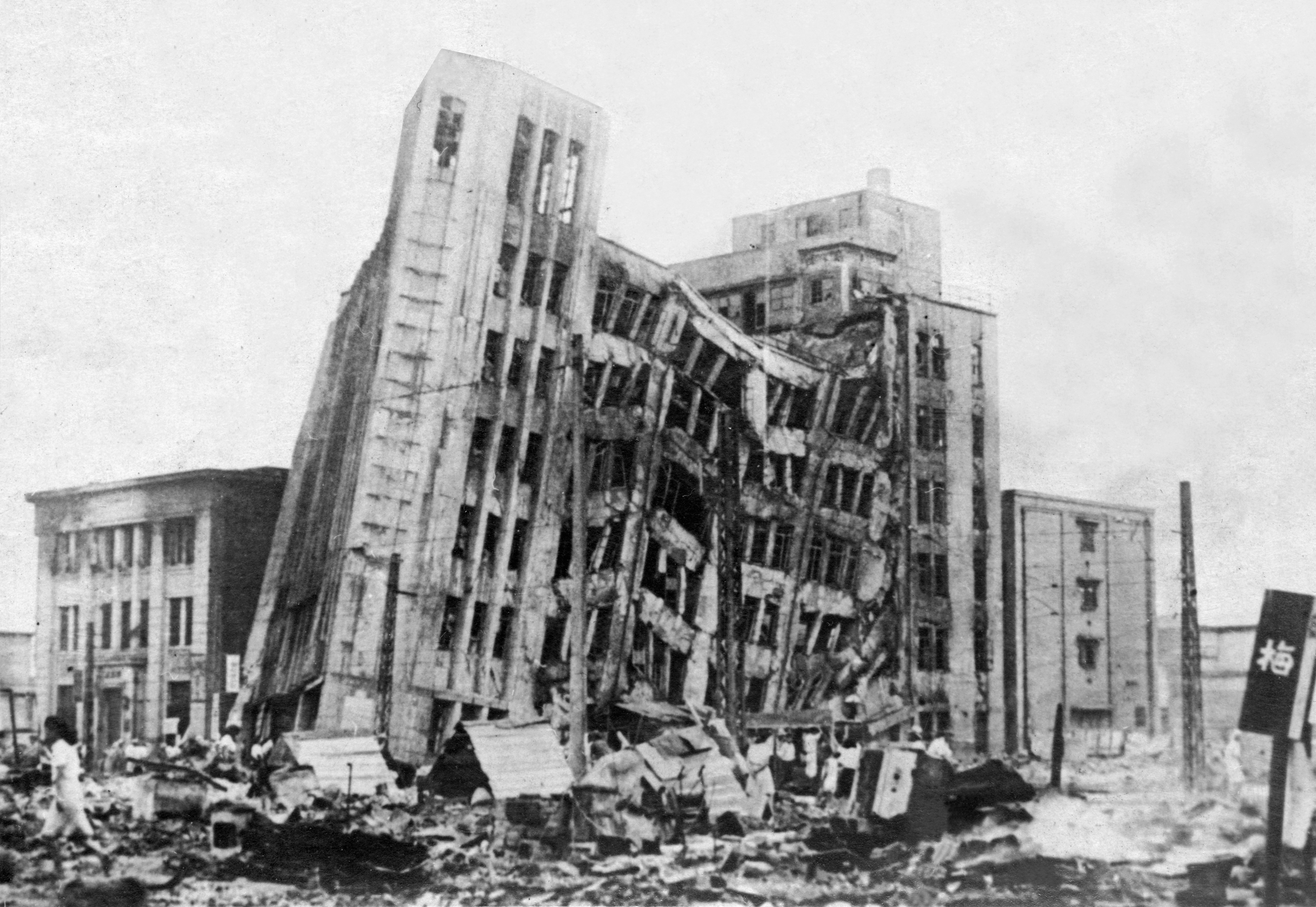
The earthquake revealed a strike-slip fault that geologists had never mapped. Stretching from Kanazu to Fukui, the fracture was later named the Fukui Earthquake Fault. The shaking registered as intensity 6 on the Japan Meteorological Agency scale -- so extreme that it prompted the agency to add an entirely new category, Shindo 7, to its seismic intensity scale. The tremors were felt as far east as Mito and as far west as Saga, spanning much of the Japanese archipelago. At the epicenter, the contrast between neighboring buildings told a stark story about construction methods: the Daiwa Department Store collapsed completely, while the Fukui Bank building immediately next door suffered no significant damage, protected by approximately 500 deep foundation piles driven 10 meters into the ground.
When the River Broke
The earthquake's destruction did not end with the shaking. The force of the quake seriously damaged the embankments of the Kuzuryu River, which flows through the Fukui plain. In the weeks that followed, record-setting rainfall hammered the region. The weakened levees could not hold, and they burst, sending floodwater across a landscape already flattened by the earthquake and scorched by fire. Maruoka Castle, one of the area's most treasured historic structures, had collapsed in the quake. Train stations at Hosorogi and Kanazu (now Awaraonsen Station) were destroyed. A theater in Fukui had collapsed and caught fire during the initial earthquake, killing several hundred people trapped inside. Now the floods added another layer of ruin to a city that had already endured more than seemed possible.
City of the Phoenix
The 1948 Fukui earthquake was, at the time, the deadliest earthquake in Japan since the end of the Pacific War, a grim record it held until the Great Hanshin earthquake of 1995. The death toll in Sakai City alone exceeded one percent of the population. And yet, Fukui refused to stay down. Three years of wartime bombing, a catastrophic earthquake, citywide fires, and devastating floods had reduced the city to ashes four times over. The citizens rebuilt each time. In recognition of this extraordinary resilience, the Fukui citizen's charter officially proclaimed Fukui the "City of the Phoenix" -- a name the city carries to this day. Walking through modern Fukui, with its orderly streets and rebuilt infrastructure, it takes deliberate effort to imagine the layered catastrophes that shaped it. The phoenix did not just rise once; it rose again and again.
From the Air
Located at 36.16N, 136.22E in the Fukui plain, Fukui Prefecture. The earthquake epicenter was approximately 10 km north-northeast of Fukui city center, near present-day Maruoka in Sakai City. From altitude, the flat alluvial plain of the Fukuiheiya is clearly visible, bounded by mountains and bisected by the Kuzuryu River. Nearest major airport is Komatsu Airport (RJNK), about 40 km to the northeast. Fukui Airport (RJNF) is a smaller regional field approximately 10 km south of the epicenter. The city grid of modern Fukui, rebuilt after the earthquake, is visible as a distinctly ordered layout on the flat plain.