1964 Niigata Earthquake
One apartment building lies perfectly on its side, windows unbroken, walls uncracked, as if a giant simply tipped it over like a domino. The photograph from June 16, 1964, became one of the most reproduced images in earthquake engineering -- not because of the destruction it shows, but because of what it reveals about the treacherous ground beneath our feet. When a magnitude 7.6 earthquake struck Niigata at 1:01 in the afternoon, the sandy soil beneath the city did something engineers had observed before but never fully understood. It liquefied. Solid ground behaved like a thick soup, and the reinforced concrete apartment buildings of the Kawagishi-cho housing complex, structurally sound and barely damaged by the shaking itself, simply sank and tilted into the earth as their foundations lost all support.
When the Ground Turned to Water
The geology beneath Niigata was a time bomb. The city sits on the delta of the Shinano River, Japan's longest, where centuries of sediment had created deep layers of loose, water-saturated sand. Years of pumping groundwater to extract water-soluble natural gas had compounded the problem, causing the land to subside an average of 20 centimeters per year through the 1950s. When the earthquake's seismic waves hit this saturated ground, the sand grains lost contact with each other and the soil temporarily became fluid. Sand volcanoes erupted across the city, spewing water and sediment to the surface. Subsidence of up to 140 centimeters was measured over wide areas. Maps of the liquefaction damage matched almost perfectly with old maps showing former river channels -- the ground remembered what it once was.
Twelve Days of Fire
Five hours after the earthquake, a new disaster began. Damaged pipes at the Showa Shell Sekiyu oil refinery released gasoline that was carried to the surface by the tsunami and by underground water forced up through liquefied soil. The fuel ignited, and the fire leapt from tank to tank as explosions fed the blaze. At the time, Niigata City's specially designed chemical fire truck had not yet been deployed. A desperate request went to Tokyo, and firefighting troops raced north. For twenty hours they battled to keep the flames from reaching an attached oxygen tank that could have turned the inferno into something far worse. They succeeded, but the refinery fire continued burning for twelve days -- what was called the worst industrial complex fire in the country's history.
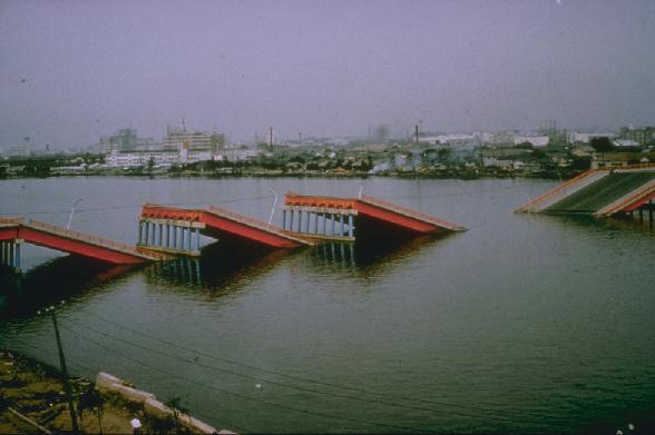
The Bridge That Waited Seventy Seconds
The Showa Bridge's collapse offered a puzzle. Eyewitnesses reported that the bridge stood firm through the earthquake's main shaking, only to fail a full seventy seconds after the tremor began. The timing ruled out direct ground motion as the cause. Instead, the liquefied soil beneath the riverbed spread laterally, dragging the bridge's deep foundation piles sideways until the structure could no longer hold. The bridge's girders dropped into the Shinano River. Meanwhile, the Bandai Bridge, one of the city's main commuter crossings, survived intact but bore permanent scars. The streets running beneath it on each bank now sit at different elevations -- roughly one meter apart -- a visible reminder of how unevenly the ground settled. The bridge itself sank only about 10 centimeters during the earthquake, but combined with years of prior subsidence, it has settled a total of 1.2 meters from its original position.
Waves from the Sea of Japan
Fifteen minutes after the shaking stopped, the first tsunami wave reached Niigata City. The waves battered Sado Island, Awa Island, and traveled as far as the Oki Islands in Shimane Prefecture. At Ryotsu Harbor, the wave reached 3 meters. Near Iwafune Harbor, it crested at 4 meters. On sandy beaches, where run-up amplified the surge, the water climbed to 6 meters. In some places the first wave was the highest; in others, the third wave proved worse. Successive waves arrived at intervals of 20 to 50 minutes. In certain low-lying areas, the flooding persisted for up to a month. Combined with the liquefaction and years of land subsidence, the tsunami turned the earthquake into a compound disaster that left 36 people dead or missing, 385 injured, 3,534 houses destroyed, and another 11,000 damaged.
The Textbook Earthquake
The 1964 Niigata earthquake killed relatively few people, but it transformed earthquake science. Along with the Great Alaska earthquake that struck just three months earlier, it forced engineers worldwide to confront soil liquefaction as a primary seismic hazard rather than a curiosity. The images of the Kawagishi-cho apartments -- tilted at sharp angles yet structurally intact -- became the defining visual for liquefaction research. New building codes followed. Foundation design standards changed. The understanding that a building could survive shaking only to be swallowed by its own foundation soil reshaped construction practices across Japan and around the world. Today, Niigata has rebuilt completely, but the lessons of June 16, 1964, remain embedded in engineering textbooks on every continent.
From the Air
Located at 38.37N, 139.22E on the Sea of Japan coast of Honshu. The epicenter was offshore on the continental shelf, roughly 50 km north of Niigata city. From the air, the Shinano River delta and Niigata's coastal plain are clearly visible, with the river's channels cutting through the urban area. Nearest airport: Niigata Airport (RJSN), directly adjacent to the city. The Showa Bridge site and Kawagishi-cho area are along the Shinano River within the city proper. Look for the broad river delta and coastal flatlands that hint at the sandy, liquefaction-prone soils below.