1972 Sidney Lanier Bridge Collapse
The pilot's orders were clear: "LEFT, 10 degrees." But at 9:43 p.m. on November 7, 1972, somewhere in the cramped wheelhouse of the SS African Neptune, those orders went wrong. The replacement helmsman turned the rudder right instead of left, and by the time anyone noticed, the 11,000-ton cargo ship was committed to a path that would take it straight into the Sidney Lanier Bridge over the Brunswick River. Thirteen minutes after leaving the dock, the African Neptune struck the bridge's southern span. Three sections collapsed into the dark tidal water, taking ten cars, two semi-trucks, and twenty-four people with them. Ten would not survive the night.
A Bridge That Sailors Feared
The Sidney Lanier Bridge had been trouble since it opened in 1956. A vertical-lift bridge carrying U.S. Route 17 across the Brunswick River in coastal Georgia, it featured a notoriously narrow opening that large oceangoing vessels had to thread to reach the Port of Brunswick. Ships with wide turning radii had to begin aligning themselves well before reaching the bridge, leaving almost no margin for error. A 2012 article in The Brunswick News described the passageway as "small" and "dangerous" for large ships. The bridge sat low over the tidal river, its main span only a few dozen feet above the water, and seamen knew it by reputation. When Captain Frank Stanejko brought the African Neptune to the channel entrance on the night of November 6, he made the cautious decision to wait until morning rather than attempt the passage in darkness.
Thirteen Minutes to Disaster
Heavy rain delayed the African Neptune's departure until 9:36 p.m. the following evening. The ship, loaded with resin bound for Kenya, was assisted out of the State Docks by a tugboat before maneuvering under its own power toward the bridge. Captain Stanejko had already replaced the original helmsman, who crewmember Henry Billitz later said was drunk on duty. But the replacement helmsman made a catastrophic error: when the pilot ordered the rudder turned left to align with the bridge opening, the helmsman turned right. By 9:46 p.m., the ship had passed the point of no return. The mate finally noticed the rudder angle indicator showing 10 degrees right and climbing. Frantic orders followed - hard left, full astern, drop the anchor - but the ship's momentum was unstoppable. At 9:50 p.m., the African Neptune struck the bridge roughly south of the vertical-lift span. The impact tore three sections from the structure and sent them plunging into water along with everyone and everything on the bridge above.
Darkness on the River
Of the twenty-four people who fell into the Brunswick River that night, some managed to cling to the damaged bridge structure. Crewmembers aboard the African Neptune threw lifebuoys and launched lifeboats. The bridge operator called the Brunswick Police Department while a distress signal went out across the harbor. Responders converged from across the region - Jekyll Island police, the Georgia State Patrol, Civil Defense units - but rain and darkness hampered their search. Survivors were rushed to Glynn-Brunswick Memorial Hospital. The Associated Press initially reported just one dead and eight missing, but the toll climbed through the next day. By November 12, the last of ten bodies had been recovered from the wreckage. Georgia Governor Jimmy Carter traveled to Brunswick to inspect the damage and speak with the ship's crew.
What Went Wrong in the Wheelhouse
The Coast Guard and NTSB investigations, published in May 1974, traced the disaster to the wheelhouse design as much as to human error. The steering wheel was small and partially hidden from view, making it impossible for others in the wheelhouse to see which direction it was being turned. The rudder order indicator was a tiny instrument recessed into a panel that required close proximity to read. The mate, who might have caught the error sooner, was occupied with other duties. Neither the shipmaster, the pilots, nor the mate was monitoring the helmsman's inputs closely enough to catch the mistake before the point of no return. The bridge's own design compounded the problem: ships were required to be actively turning as they passed the commitment point, leaving zero recovery time if anything went wrong.
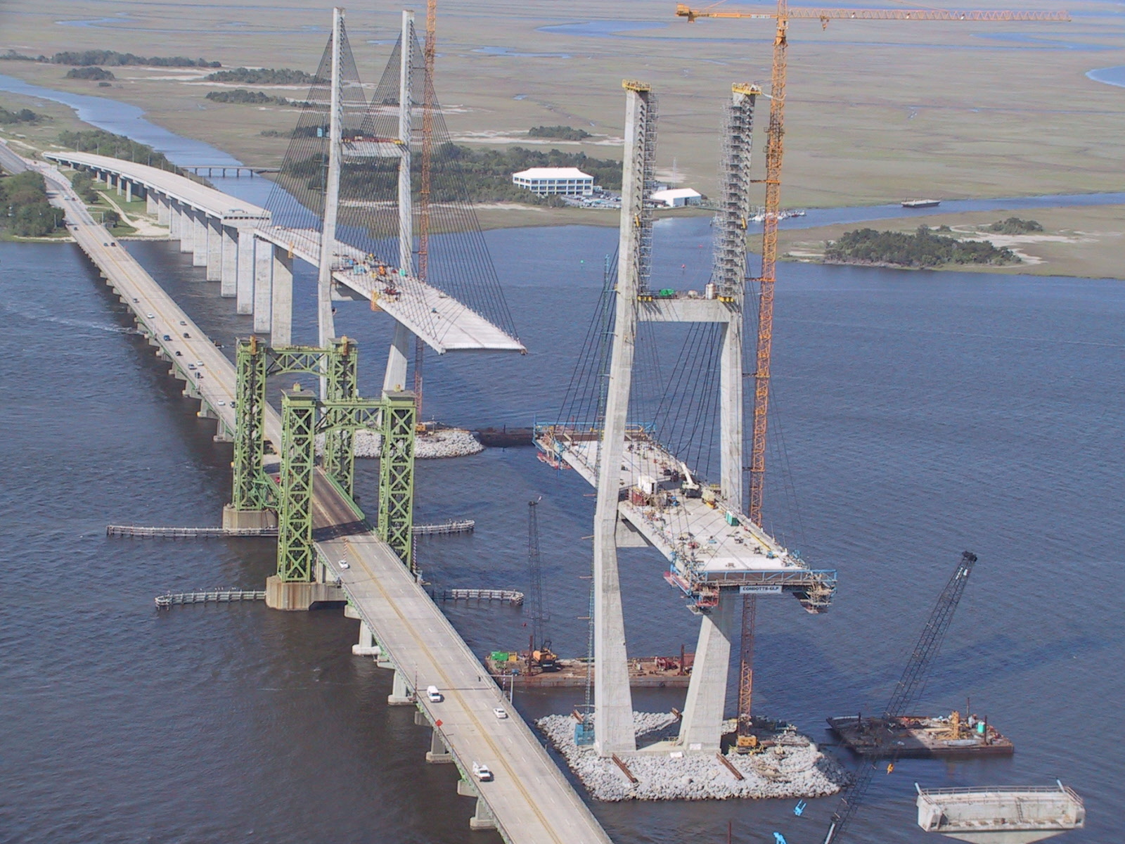
A Bridge Replaced
Repairs took six months and cost $1.3 million. With Interstate 95 not yet built through Glynn County, the only detour ran through Georgia State Route 303 on Blythe Island. New barricades were installed to keep cars off the main span whenever the lift section was raised. But the bridge's troubles were not over. In 1987, the Polish cargo ship Ziemia Bialostocka struck a support tower while passing through, causing $3 million in damages and another five-month closure. The Coast Guard finally declared the bridge a navigational hazard. In 2003, the old vertical-lift bridge was replaced by a new cable-stayed design - Georgia's longest and tallest bridge - with artificial islands protecting its pylons and a main span wide enough that no ship would ever need to thread a needle again. The 1972 collision, officials acknowledged, had been the driving argument for the replacement. A small section of the old bridge was saved and converted into a fishing pier - a quiet memorial to the night the African Neptune turned the wrong way.
From the Air
Located at 31.116N, 81.486W over the Brunswick River in Brunswick, Georgia. The modern Sidney Lanier cable-stayed bridge (completed 2003) is a dramatic landmark visible from considerable altitude - Georgia's longest and tallest bridge with distinctive twin towers and cable stays. The bridge crosses the Brunswick River just south of downtown Brunswick. Nearby airports include Brunswick Golden Isles Airport (KBQK) approximately 5 nm to the north and McKinnon St. Simons Island Airport (KSSI) approximately 6 nm to the southeast. The Golden Isles barrier islands (St. Simons, Jekyll Island, Sea Island) are visible to the east. Best viewed at 2,000-4,000 ft AGL for bridge detail. Expect sea breeze effects and possible coastal fog.