1979 Red River Valley Tornado Outbreak
The scientists were already watching. By sheer coincidence, NASA had a field campaign running in the Red River Valley on April 10, 1979 -- the Severe Environmental Storms and Mesoscale Experiment, or SESAME -- when the atmosphere assembled one of the most destructive tornado outbreaks in American history. At least 22 tornadoes touched down that Tuesday, two rated F4 on the Fujita scale. They struck Vernon, Texas. They struck Lawton, Oklahoma. And then the largest of them carved a path through the heart of Wichita Falls, Texas, killing at least 45 people, injuring nearly 1,800, and leaving approximately 20,000 people homeless. The $400 million damage toll -- $1.865 billion in 2025 dollars -- made it the costliest tornado on record at that time. In the communities along the Oklahoma-Texas border, the date acquired a name that needed no further explanation: Terrible Tuesday.
The Atmosphere Loads Its Gun
The meteorological setup was textbook violent. On April 9, a strong upper-tropospheric trough sat over the western United States while a powerful jet stream extended from the eastern Pacific to South Texas. A cold front pushed south but weakened over Texas, leaving warm, moist air pooled ahead of the disturbances. By the morning of April 10, the trough had assumed a negative tilt -- a configuration notorious for spawning severe weather. An occluded front stretched from a rapidly intensifying low-pressure system in Colorado into the Texas Panhandle. Dew points surged northward. Wind shear intensified over the Red River Valley. The National Severe Storms Forecasting Center issued a tornado watch at 1:55 p.m. CST. Within the watch area, air pressure dropped sharply in three hours -- the kind of drastic pressure fall that precedes tornado outbreaks.
Vernon Falls First
The first of three intense supercell thunderstorms spawned a tornado in southern Foard County at 2:05 p.m. CST. A second tornado from the same storm formed near Thalia around 3:20 p.m. and tracked northeast into Wilbarger County toward Vernon. The tornado entered Vernon at approximately 3:45 p.m., destroying residential blocks along Gordon and Atlanta streets in the southern part of the city. In eastern Vernon, the Wilbarger Exhibit Building and a Texas Highway Department warehouse were razed. The tornado then crossed US 287, blowing vehicles off the highway and killing seven people on the road. Ten people died in Vernon. Ted Fujita and Roger Wakimoto, surveying damage from a low-flying Cessna two days later, assessed the Vernon damage at low-end F4. The tornado crossed the Pease River, continued into Oklahoma near Davidson, and finally lifted after covering a path of approximately 50 miles.
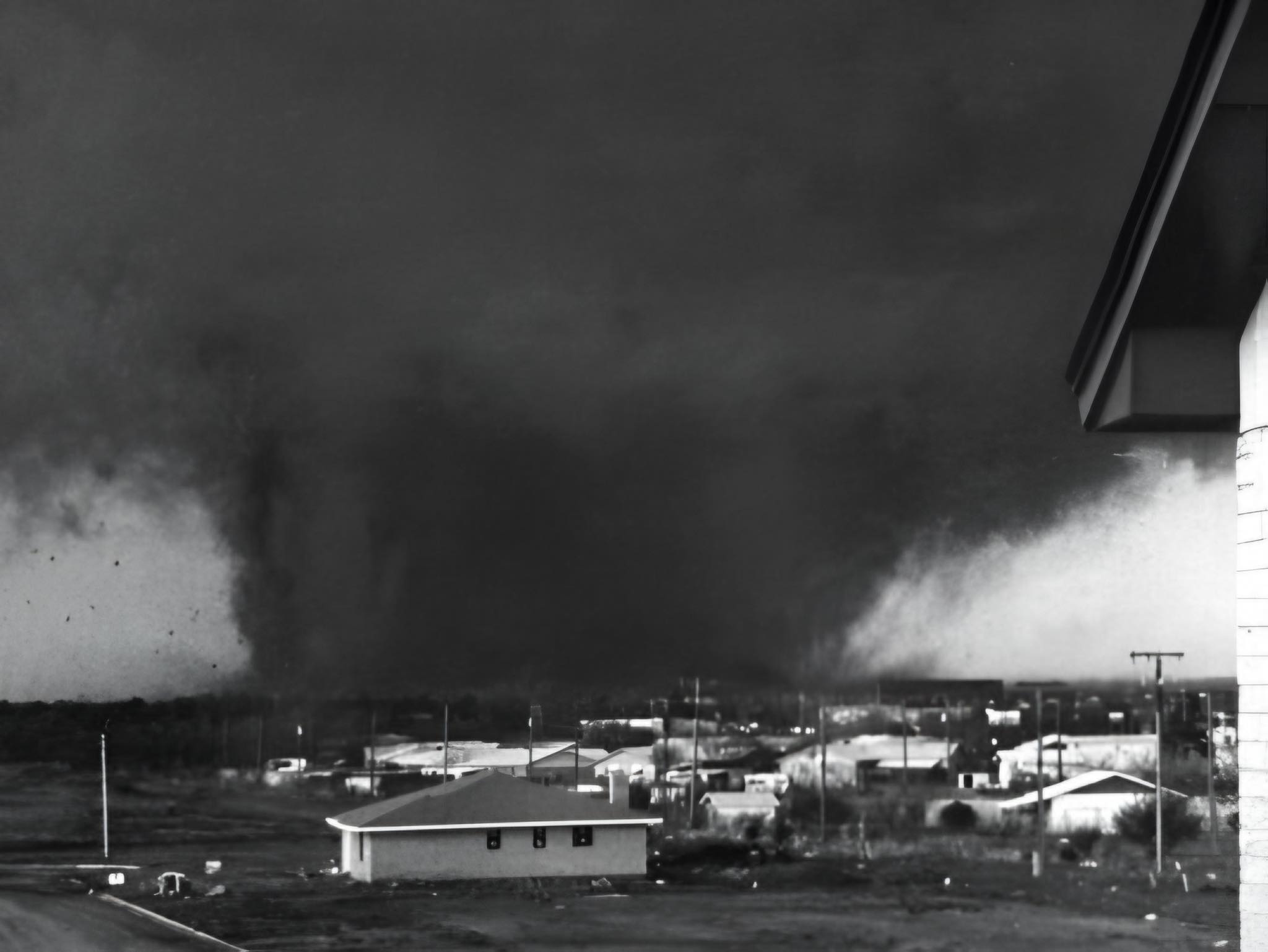
The Monster in Wichita Falls
The most devastating tornado of the day began east-northeast of Holliday, Texas, around 5:50 p.m. CST. It moved east-northeast directly into Wichita Falls, carving through densely populated residential neighborhoods. The funnel expanded to enormous width as it crossed the city, with the most severe damage occurring within a wide central swath. The destruction was staggering: 2,095 homes destroyed, 1,062 apartment units flattened, 93 mobile homes obliterated. Over 3,000 homes were rendered uninhabitable. Between 10 and 20 percent of the city's population -- roughly 20,000 people from 5,000 families -- were left homeless in a single evening. Of the 45 fatalities, 25 were vehicle-related. Eleven people died after fleeing their undamaged homes to drive away from the tornado, only to be caught in their cars. Only five deaths occurred indoors.
The Lesson Written in Wreckage
The vehicle death toll changed how Americans were taught to respond to tornadoes. Before Wichita Falls, conventional wisdom sometimes encouraged driving away from an approaching funnel. The 1979 data showed that cars were death traps: tornadoes mangled and tossed vehicles like toys, while people who sheltered indoors survived at far higher rates. The National Weather Service produced a documentary in 1984 titled Terrible Tuesday, collaborating with the American Red Cross and FEMA, using the outbreak as a case study in tornado safety. The scientific data gathered during the SESAME field campaign proved invaluable as well, contributing to improved tornado forecasting models. The outbreak also spawned additional storms on April 11, particularly in Arkansas, and the broader weather system produced intense rainfall over Mississippi and Alabama that culminated in the 1979 Easter flood, the worst disaster to hit Jackson, Mississippi, in over a century.
Crape Myrtles and Memory
Wichita Falls rebuilt. One city park now contains a plaque listing the names of the 45 people who died, with a tree planted for each victim. Another park near the downtown area features crape myrtle sculptures symbolizing the city's recovery. The outbreak reshaped emergency preparedness across the Red River Valley. Tornado sirens were upgraded, building codes were strengthened, and public awareness campaigns emphasized the lethal danger of attempting to outrun a tornado in a vehicle. In Vernon, the scars from the destroyed residential blocks eventually gave way to new construction. In Lawton, where an F3 tornado destroyed 167 buildings and killed 3 people, the military community at nearby Fort Sill absorbed the shock and contributed to recovery. Terrible Tuesday endures in regional memory not as a story of helplessness but as a turning point -- the day that taught the Southern Plains to take shelter.
From the Air
The 1979 Red River Valley tornado outbreak affected a broad swath from Vernon, Texas (34.15°N, 99.29°W) through Lawton, Oklahoma (34.60°N, 98.39°W) to Wichita Falls, Texas (33.91°N, 98.49°W). The catalog coordinates (38.65°N, 101.23°W) represent the article's geolocation in western Kansas. Sheppard Air Force Base (KSPS) lies near Wichita Falls. Lawton-Fort Sill Regional Airport (KLAW) serves southwestern Oklahoma. The Red River, forming the Texas-Oklahoma border, is the primary geographic reference for the outbreak zone. Viewing from 8,000-15,000 feet reveals the flat terrain of the Red River Valley that allows supercell thunderstorms to develop unimpeded across enormous distances.