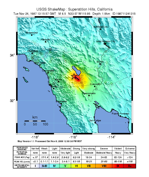
1987 Superstition Hills Earthquakes
At 5:54 PM on November 24, 1987, the earth moved twice. First came the magnitude 6.2 Elmore Ranch earthquake, striking southwest of Westmorland in California's Imperial Valley. Twelve hours later, the magnitude 6.5 Superstition Hills mainshock hit along the San Jacinto Fault Zone. The Superstition Mountain seismic station recorded 0.9g horizontal acceleration, the largest and longest reading in its 55-year history. The ground did not stop moving for nearly a year, as aseismic slip continued along the Superstition Hills Fault, slowly increasing displacements long after the initial violence had passed. In the transition zone where the San Andreas Fault system meets the spreading Gulf of California, the Imperial Valley had once again demonstrated why it ranks among the most seismically active regions in North America.
Where Continents Tear Apart
The Imperial Valley occupies a unique position in California's geology. Here, the San Andreas Fault and San Jacinto Fault Zone discontinue, marking a transition between continental transform faulting and oceanic rifting extending into the Gulf of California. The Brawley seismic zone, between the San Andreas and Imperial faults, represents the northernmost ridge feature in this complex boundary. Faults here trend northeast, perpendicular to the main plate boundary, producing left-lateral strike-slip motion. The San Jacinto Fault Zone, running parallel to the San Andreas for its length, is southern California's most seismically active fault system, responsible for a large surface-rupturing earthquake in 1968 and triggered slip during events in 1956, 1968, and 1979.
The Double Strike
The magnitude 6.2 foreshock occurred on a previously unmapped fault, later named the Elmore Ranch Fault Zone. It ruptured bilaterally, extending northeast toward the Brawley Seismic Zone and southwest to join the Superstition Hills Fault. Surface ruptures showed left-lateral slip with maximum offsets of nearly a foot. Twelve hours later, the mainshock struck where the Superstition Hills Fault intersects the Elmore Ranch Fault Zone. The earthquake generated surface ruptures with right-lateral offsets observed along two sections of the fault and along the Wienert Fault. Twenty-five seismic stations within range of the epicenter recorded peak ground acceleration exceeding 0.1g, with all showing at least 0.3g.
A Year of Creeping
The earthquakes did not end on November 24. Over 339 days, the Superstition Hills Fault continued producing aseismic slip, steadily increasing ground displacements. The Wienert Fault's southern portion generated vertical offsets that were actively growing when observed in 1988. These movements may have begun less than three minutes after the two large earthquakes. The Imperial Fault also began moving about three hours after the mainshock. This prolonged ground movement, invisible but measurable, demonstrated how major earthquakes can trigger cascading effects across interconnected fault systems, reshaping the landscape long after the shaking stops.
Damage Across the Border
The earthquakes struck a sparsely populated region, limiting casualties despite their magnitude. Two people died in Mexicali, Mexico, where 50 were injured and building damage was considerable. Another 44 people were injured in the Imperial Valley. In El Centro, Imperial, and Westmorland, chimneys collapsed, pipes ruptured, and windows shattered. The rebuilt Imperial County services building, designed after earlier seismic lessons, remained structurally intact. Canal infrastructure sustained significant damage. At the San Onofre Nuclear Plant, an unusual event declaration was issued. A runway at Naval Air Facility El Centro required closure for inspection, revealing small cracks. The shaking was felt more than 180 miles away in Las Vegas, Nevada, and Tempe, Arizona, and across the border in Tijuana and Ensenada.
Living on the Edge
The Imperial Valley continues to experience regular seismic activity. The 1987 Superstition Hills earthquakes, while larger than the Whittier Narrows earthquake that struck Los Angeles the previous month, caused less damage precisely because they occurred in agricultural land rather than urban areas. The sparsely populated farmland that produces much of America's winter vegetables sits atop one of the continent's most active fault zones. The Salton Sea shimmers to the north, itself a creation of geological and human forces. Irrigation canals crisscross the valley, carrying Colorado River water to transform desert into farmland. Beneath it all, the earth continues its slow tearing, the Gulf of California creeping northward one earthquake at a time.
From the Air
Located at 33.09°N, 115.79°W in California's Imperial Valley. The Superstition Hills and Superstition Mountain are visible landmarks. Nearest airports: Imperial County Airport (IPL) 15nm east, Jacqueline Cochran Regional Airport (TRM) 30nm north. Best viewed at 5,000-6,000 feet AGL. The Salton Sea is visible to the north, the irrigated Imperial Valley farmland spreads below, and the arid terrain of the fault zone contrasts sharply with the green agricultural checkerboard.