1993 Storm of the Century
Forecasters saw it coming five days out, and they still could not believe what the computer models were telling them. On March 8, 1993, numerical weather prediction models at the National Weather Service began converging on a scenario so extreme that meteorologists initially questioned whether the data could be real: a massive cyclone that would stretch from Central America to eastern Canada, drop snow on places that almost never saw it, and generate hurricane-force winds over the Gulf of Mexico. They issued blizzard warnings two days before the storm arrived. Several northeastern states declared states of emergency before a single flake had fallen. It was the first time in American weather forecasting history that a storm's severity had been predicted accurately five days in advance. Even so, the 1993 Storm of the Century exceeded expectations.
Born in the Gulf
The storm's origins reached back two years and halfway around the world. The 1991 eruption of Mount Pinatubo in the Philippines had injected a massive aerosol cloud into the stratosphere, raising temperatures there by several degrees and altering atmospheric circulation patterns for three years. While not directly responsible, the volcanic winter may have helped set the stage. On March 11 and 12, 1993, an arctic high-pressure system built over the Midwest and Great Plains while an area of low pressure formed over Mexico along a stationary front. Tropical moisture from the Gulf of Mexico fueled an initial burst of convective precipitation off the southern coast of Texas. Supported by a strong split-polar jet stream and a shortwave trough, the system underwent rapid intensification, a process meteorologists call bombogenesis. All-time low barometric pressure records were shattered between Tallahassee and Washington, D.C. By the afternoon of March 12, the cyclone was a monster.
Hurricane on Land, Blizzard on Top
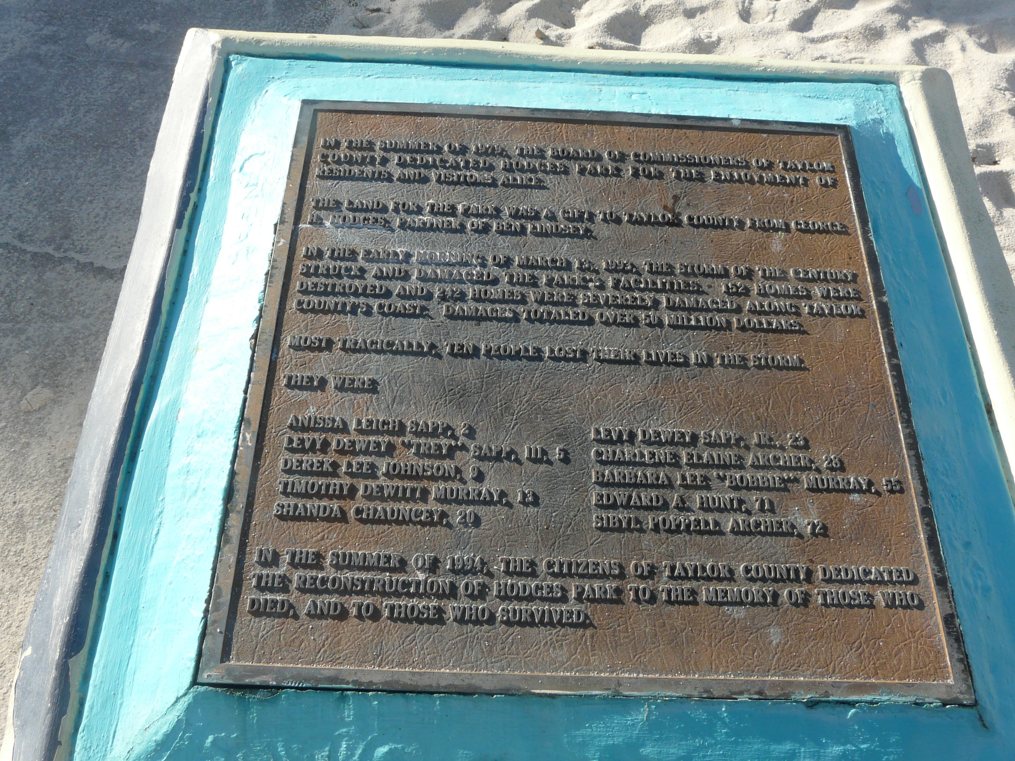
The storm defied categories. A massive squall line pushed from the Gulf of Mexico into Florida and Cuba, producing 59,000 cloud-to-ground lightning strikes and spawning at least 11 tornadoes. An F2 tornado struck near Chiefland in Levy County, killing three people. Along the Big Bend of Florida, hurricane-force winds drove a 12-foot storm surge that drowned 13 people in Taylor County. Wind gusts hit 110 mph in Franklin County, Florida, 109 mph at the Dry Tortugas, and 144 mph at Mount Washington, New Hampshire. Meanwhile, heavy snow blanketed places that rarely see it. Birmingham, Alabama recorded a rare deep snowfall. The Florida Panhandle turned white. Snow flurries were spotted as far south as Jacksonville, and parts of central Florida received a trace. From Georgia to Pennsylvania, thundersnow rumbled through whiteout conditions. At its height, the storm stretched from Honduras to Canada.
A Nation Shut Down
The scope of disruption was staggering. At least 26 states and much of eastern Canada were affected. Every airport from Halifax, Nova Scotia, to Tampa, Florida was temporarily shut down. Highways were closed or restricted across the entire eastern seaboard, even in states accustomed to severe winter weather. More than 10 million households lost electricity. An estimated 40 percent of the country's population experienced the storm's effects in some form. Over $2 billion in property damage was concentrated across 22 eastern states, with Florida bearing the brunt. The storm damaged or destroyed 18,000 homes. Over 300 people died from direct and indirect causes. Record cold temperatures settled across the Southern and Eastern United States in the storm's wake, prolonging the misery for days after the system tracked up the East Coast on Saturday March 13 and finally pushed into Canada by early Monday morning.
The Forecast That Changed Everything
The Storm of the Century became a landmark not just for its destruction, but for the science that preceded it. For the first time, National Weather Service meteorologists had accurately predicted a storm system's severity five full days before it struck. Medium-range forecasters identified the threat by March 8 using operational numerical weather prediction models. When shorter-range models confirmed the predictions, official blizzard warnings went out two days ahead of the storm. State governments acted on the warnings, declaring emergencies before the snow started falling. The success validated years of investment in computational weather modeling and fundamentally changed how emergency managers and the public responded to forecast warnings. Before 1993, the idea of declaring a state of emergency based on a computer model's five-day forecast seemed absurd. After the Storm of the Century, it became standard practice.
The Sky Remembers
The 1993 Superstorm dissipated over the North Atlantic on March 15, three days after it formed. It left behind a landscape transformed: buried cars, flattened homes along the Gulf Coast, and a population newly aware of what winter weather could do to places more accustomed to sunshine. The storm earned several names -- the 93 Superstorm, the No Name Storm, the Great Blizzard of 1993 -- but the one that stuck captured its singular nature. It was, and remains, the Storm of the Century. From the air over north-central Florida today, the Big Bend coastline looks serene, the salt marshes and hammocks giving no sign that hurricane-force winds once drove a wall of water across this low-lying shore. The calm is deceptive. The atmosphere above the Gulf of Mexico assembled this storm in a matter of hours, and the land below still carries the lesson: when the Gulf, the jet stream, and an arctic front converge, the result can reshape a continent.
From the Air
The storm's geographic center when placed at 29.50°N, 82.88°W corresponds to the Big Bend region of Florida where some of the worst storm surge damage occurred. Taylor County and Levy County were ground zero for the Gulf Coast impacts. Nearest airports include Gainesville Regional Airport (KGNV), Cross City Airport (KCTY), and Cedar Key. The area is flat coastal terrain along the Gulf of Mexico. The storm's track ran from the Gulf of Mexico up the entire Eastern Seaboard. At altitude, the Big Bend coastline and its low-lying salt marshes are visible. Best viewed from 3,000-5,000 feet AGL to appreciate the low-lying vulnerability of this coast.