2007 Peru Earthquake
It was a Wednesday evening in Pisco, and most families were at home. At 6:40 PM local time on August 15, 2007, the ground began to move -- and kept moving for two full minutes. The magnitude 8.0 earthquake that struck Peru's central coast was generated 39 kilometers below the seafloor, where the South American plate thrust upward and seaward over the Nazca plate with a violence that experts said occurs roughly once a century. The epicenter lay 150 kilometers south-southeast of Lima, but the destruction radiated outward in every direction, reaching its most extreme intensity along the Pan-American Highway near the coast.
A Coast That Remembers
Peru's central coast sits atop one of the most seismically active zones on the planet. The August 15 shock originated near the source of two previous magnitude-8 earthquakes, in 1908 and 1974. To the north, a magnitude 8.2 earthquake had struck in 1966. To the south, a magnitude 8.4 quake devastated the Arequipa region in 2001. The largest recorded earthquake along this coast -- a magnitude 9 event in 1868 near Arica -- generated a tsunami that killed thousands along the Peruvian shoreline and caused damage as far away as Hawaii. For geologists, the 2007 event was not a surprise but an inevitability, the latest in a long sequence of seismic ruptures along the Peru-Chile subduction zone. For the people of Pisco, Ica, and Chincha Alta, the scientific context offered no comfort.
When the Sea Followed
Tsunami warnings went out immediately to Peru, Ecuador, Chile, Colombia, and Hawaii. Parts of the port city of Callao were evacuated. Watches extended to Panama, Costa Rica, Nicaragua, Guatemala, El Salvador, Mexico, and Honduras. Most of these were cancelled when only a 25-centimeter wave reached distant shores, but along the Peruvian coast the story was different. The tsunami flooded part of Lima's Costa Verde highway and inundated much of Pisco's shoreline. Near Paracas, in the zone of Lagunillas, waves reached 5 meters. At Yumaque, the maximum recorded wave height was 10.05 meters. The fishing village of Lagunilla was completely destroyed -- three of its seven inhabitants died -- though survivors reported that the buildings had actually withstood the earthquake itself. It was the ocean that finished what the ground had started.
Chaos Before Coordination
The government reported 510 deaths by the following morning. The final toll reached 595 people dead. Peru's National Institute of Civil Defence led the response, supported by military forces, international NGOs, and UN agencies. A Consolidated Appeals Process raised approximately $37 million in aid, with $9.5 million coming from the Central Emergency Response Fund. But the initial response was chaotic. Information about conditions on the ground was scarce, coordination between local, regional, and national governments broke down, and political wrangling consumed energy that survivors desperately needed directed elsewhere. Some local officials were physically attacked by people searching for missing relatives or overwhelmed by grief. Order improved once the UN established a coordination office in Pisco and deployed a Disaster Assessment and Coordination team, but the early hours and days were defined by confusion as much as by compassion.
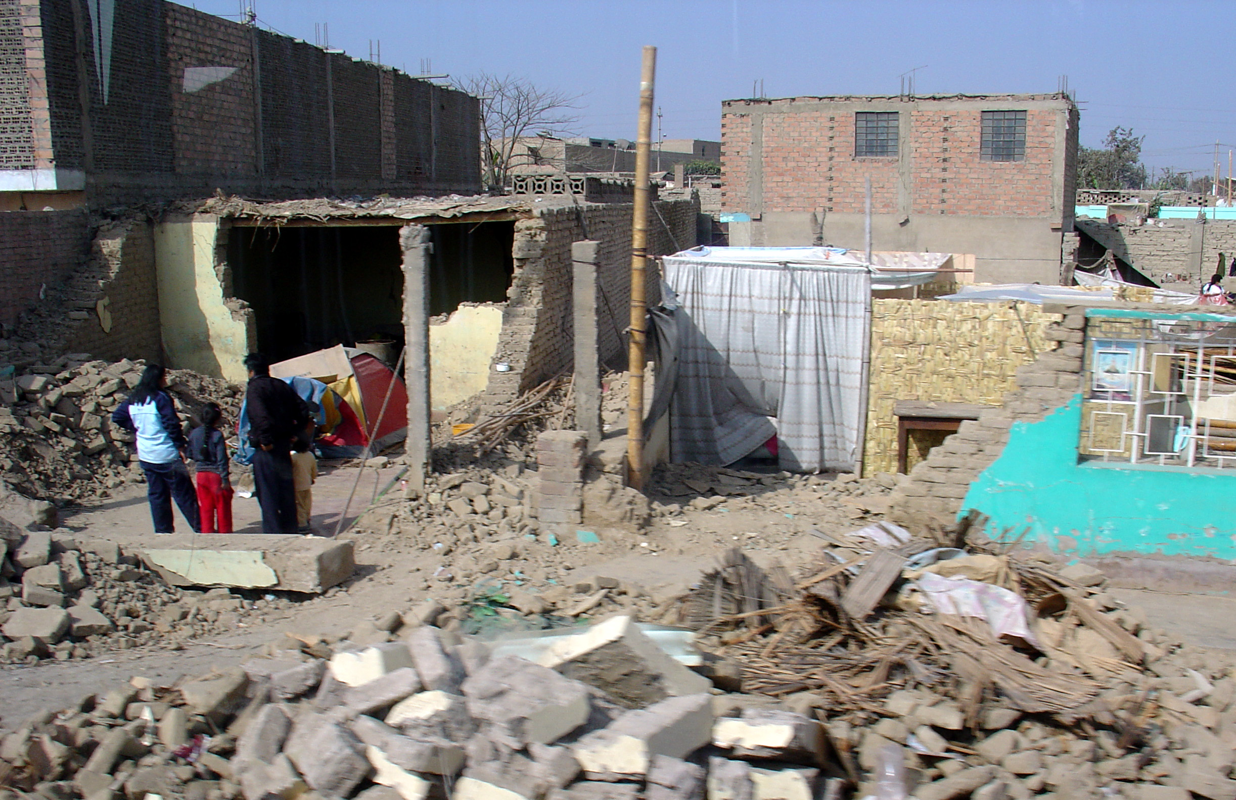
The Long Aftermath
Aftershocks rattled the region within minutes of the main event -- a magnitude 5.8 centered northeast of Chincha Alta at 7:02 PM, followed by a 5.9 near Ica at 7:19 PM. Survivors who could not be treated at overwhelmed local hospitals in Pisco were airlifted to Lima. Colombia's President Alvaro Uribe arrived in Ica four days after the earthquake, one of many international leaders who came to survey the damage. But the real story of the 2007 earthquake is measured in years, not days. Long after the news cameras left, families who lost their homes continued living in temporary shelters and tents. The social and economic wounds of that two-minute tremor proved far harder to repair than any building. Pisco's recovery became a case study in the gap between disaster relief and genuine reconstruction -- a reminder that for the people closest to an earthquake's epicenter, the event does not end when the shaking stops.
From the Air
Epicenter located at 13.35S, 76.51W, approximately 80 nm south-southeast of Lima along Peru's central coast. The affected area stretches from Pisco (SPSO) through Ica and Chincha Alta. The Pan-American Highway, visible as a major road running along the coast, was severely damaged. Lima's Jorge Chavez International Airport (SPJC) is the nearest major facility, roughly 80 nm to the north-northwest. The coastal desert terrain and the Paracas peninsula are visible landmarks. Tsunami damage was concentrated along the Pisco shoreline and near the fishing village of Lagunilla.