2009 Shizuoka Earthquake
At 5:07 in the morning on August 11, 2009, the ground beneath Suruga Bay lurched. The magnitude 6.4 earthquake jolted residents of Shizuoka Prefecture awake just days before the Obon holiday, when millions of Japanese traditionally travel home to honor their ancestors. In the cities of Izu, Yaizu, Makinohara, and Omaezaki, the shaking registered as shindo 6-minus on Japan's seismic intensity scale, strong enough to make it difficult to stand and to crack walls. One woman died in Shizuoka city. But for seismologists, the truly unsettling part was not what the earthquake did. It was what it suggested about what might come next.
The Morning the Ground Shifted
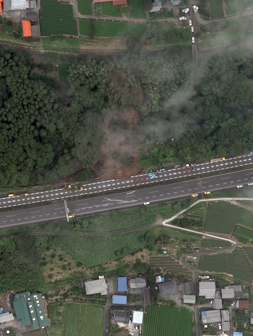
The earthquake's epicenter lay within Suruga Bay itself, at a depth of roughly 23 kilometers, inside the subducting Philippine Sea Plate. Across five cities, the shaking reached shindo 6-minus, an intensity where unsecured furniture topples and structural cracks appear. In total, 134 people suffered injuries and approximately 6,000 buildings sustained damage. The Tomei Expressway, the critical highway artery connecting Tokyo to Nagoya, suffered shoulder damage that snarled traffic on one of Japan's busiest road corridors. The timing made the disruption worse: the earthquake struck just before the peak of summer travel season, when the expressway already strains under holiday congestion.
A Fault Line in Waiting
Shizuoka Prefecture sits atop one of the most closely watched tectonic boundaries on Earth. The Philippine Sea Plate dives northwestward beneath the Eurasian Plate along the Suruga Trough at a rate of four to five centimeters per year. This subduction zone is the source of the anticipated Tokai earthquake, a magnitude 8 or greater megathrust event that seismologists consider overdue. The last time the neighboring Tonankai and Nankai segments ruptured was in 1944 and 1946, respectively, but the Tokai segment has remained locked, accumulating stress for over 170 years. The 2009 earthquake occurred at the eastern edge of this anticipated rupture zone, roughly 10 kilometers deeper than the plate boundary interface, making it what researchers call an intra-slab event rather than the dreaded megathrust itself.
The Stress That Stayed
Research published in Nature Geoscience following the 2009 event delivered a sobering conclusion: the earthquake had actually increased seismic stress on the strongly locked patches of the Tokai fault plane. Rather than releasing tension in the system, the magnitude 6.4 quake added to it. Scientists observed that the occurrence rate of plate-boundary seismicity increased after the event, with most of the presumed locked patches of the Tokai segment sitting within areas of heightened stress. Japan's Earthquake Early Warning system, one of the most advanced in the world, had provided seconds of advance notice before the shaking reached populated areas. But seconds of warning cannot substitute for the fundamental uncertainty that defines life along the Suruga Trough: nobody knows when the Tokai segment will finally rupture.
Living on the Edge
Shizuoka Prefecture has spent decades preparing for the earthquake that has not yet come. Schools run regular evacuation drills. Buildings are constructed to strict seismic codes. Coastal communities maintain tsunami evacuation routes. The 2009 earthquake served as both a rehearsal and a reminder. The damage was real but manageable, the kind of event that tests systems without overwhelming them. For the people of Omaezaki, Yaizu, and Makinohara, the shaking at dawn confirmed what they already knew: they live in a place where the earth does not stay still. The green tea plantations of Makinohara and the fishing ports of Yaizu continue to thrive in the shadow of the Suruga Trough, a testament to the Japanese capacity for building resilient communities on restless ground.
From the Air
The 2009 earthquake epicenter was located at approximately 34.778N, 138.276E in Suruga Bay, visible as the large inlet along Shizuoka Prefecture's Pacific coast. Mt. Fuji Shizuoka Airport (RJNS) sits on the Makinohara Plateau overlooking Suruga Bay, approximately 15 km northwest of the epicenter. Hamamatsu Air Base (RJNH) lies about 70 km to the west. From altitude, the Suruga Trough is not visible, but the bay itself is a prominent geographic feature with the Izu Peninsula forming its eastern shore. The Tomei Expressway, which sustained damage, is visible as a highway corridor running east-west through the coastal plain below Mount Fuji.