2011 Assiniboine River Flood
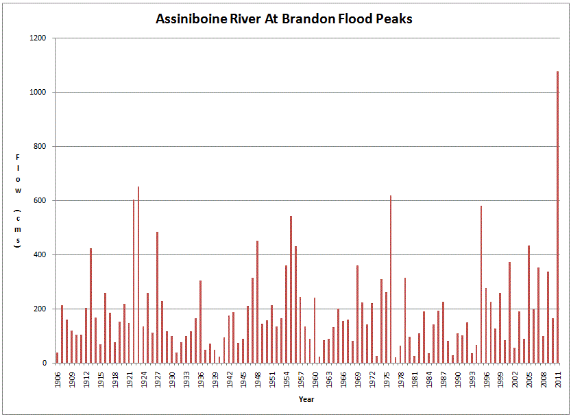
Everyone was watching the wrong river. In the spring of 2011, Manitoba braced for flooding along the Red River, the usual suspect in a province defined by its flatness and its water. But the Assiniboine, flowing east through the Westman Region of Manitoba and Saskatchewan, had other plans. Fed by relentless rainfall that began in the fall of 2010 and continued through a winter of heavy snow, the Assiniboine swelled to levels not seen in three hundred years. By the time the river peaked at Brandon, it was running sixty percent higher than the previous record set in 1923. Across Manitoba, 7,100 people were driven from their homes, and governments at every level spent close to one billion dollars fighting the water and compensating those it displaced.
A Slow-Motion Catastrophe
The 2011 flood announced itself months before the crisis peaked. Major rainfall events in the fall of 2010 saturated the Assiniboine River watershed, and wet conditions persisted through the winter. Engineers emptied the Shellmouth Reservoir during the winter of 2010-2011, preparing to absorb the spring melt. Early forecasts compared the coming flood to the one in 1995, which was manageable. But the precipitation kept coming. A heavy snowfall on April 29 and 30 blanketed the watershed, and forecasts were revised sharply upward. The first settlement to feel the rising water was St. Lazare, Manitoba, near the confluence of the Assiniboine and Qu'Appelle Rivers. Dikes went up, but some were overwhelmed. The flood spilled downstream, swallowing campgrounds and farmland across the flood plain.
Brandon Under Siege
Brandon, Manitoba's second-largest city, had time to prepare. Workers built earthen dikes alongside sandbag and Hesco bastion barriers well in advance. It was not enough to prevent a state of emergency. The Assiniboine peaked at Brandon at a level sixty percent above the previous record from 1923, making the 2011 event an estimated one-in-three-hundred-year flood. In places, the river ran twenty to thirty times wider than normal, and flood conditions persisted near the city for 120 days. Premier Greg Selinger requested military assistance from Prime Minister Stephen Harper. Canadian troops arrived to help fight the floodwaters, the first military deployment for Manitoba flood relief since the devastating 1997 Red River flood. Other municipalities across the province declared their own emergencies as the water moved relentlessly east.
The Breach at Hoop and Holler Bend
Downstream of Brandon, the math was dire. The Manitoba government forecast that between 54,000 and 56,000 cubic feet per second of water would reach the Portage Diversion reservoir near Portage la Prairie. The Diversion channel, designed to drain overflow into Lake Manitoba, could handle only a portion of that volume. The remaining 29,000 to 31,000 cubic feet per second would continue toward communities like Poplar Point, St. Francois Xavier, and Headingley before reaching the Red River at The Forks in Winnipeg. Existing dikes along the Assiniboine were built for a channel capacity of only 19,000 cubic feet per second. Facing the certainty of uncontrolled breaches, engineers made a deliberate cut at Hoop and Holler Bend, allowing the Assiniboine to spill in a controlled fashion. The intentional flood was expected to inundate farmland and up to 150 homes. In the end, the crest was downgraded, and some engineers later questioned whether the breach had been necessary at all.
The Lake That Kept Rising
The Portage Diversion channeled enormous volumes of Assiniboine floodwater into Lake Manitoba, and the lake responded by rising far beyond its normal operating range. The 2011 diversion far exceeded the volume sent into the lake during the 1976 Assiniboine flood. Residents at Delta Beach were evacuated as shoreline flooding threatened homes. Flood-fighting efforts that had been focused on the Assiniboine now shifted to the lake itself. A technical review completed in October 2013 concluded that the combined effect of the Portage Diversion and improvements to the Fairford River outlet had raised lake levels measurably, compressing what would have been years of natural rise into a matter of weeks. For the communities around Lake Manitoba, the flood did not end when the Assiniboine receded. The lake held its elevated waters long after the river had settled back between its banks.
From the Air
Centered near 49.6N, 99.5W along the Assiniboine River in the Westman Region of Manitoba. The river is visible from altitude as it meanders east through flat agricultural prairie. Brandon (CYBR) is the nearest airport. From cruising altitude, the Assiniboine's floodplain is clearly visible as a broad, green ribbon cutting through the surrounding farmland. The Portage Diversion channel is visible northeast of Portage la Prairie, and Lake Manitoba stretches to the north. The Shellmouth Reservoir is visible upstream to the northwest near the Saskatchewan border.