2011 Shizuoka Earthquake
At 10:31 PM on March 15, 2011, the ground beneath Mount Fuji lurched. Four days had passed since the magnitude-9.0 Tohoku earthquake -- the most powerful ever recorded in Japan -- had devastated the northeast coast and triggered a catastrophic tsunami. The country was still reeling. Then came this: a magnitude 6.4 earthquake centered just 42 kilometers north-northeast of Shizuoka City, at a depth of only 9 kilometers. The hypocenter sat disturbingly close to the presumed location of Mount Fuji's magma chamber. Japan's most iconic mountain, dormant since 1707, had just been shaken from the inside.
An Aftershock 300 Kilometers Away
The 2011 Shizuoka earthquake was almost certainly a triggered event -- a distant echo of the Tohoku megathrust that had ruptured the seafloor four days earlier. Seismicity had been rare around Mount Fuji since its last eruption during the Hoei period over three centuries ago, making this event immediately suspicious. The quake was classified as a sinistral strike-slip fault earthquake, meaning blocks of crust slid horizontally past each other along a left-lateral fault. Researchers at the Headquarters for Earthquake Research Promotion concluded that the massive stress redistribution from the Tohoku event -- which shifted the entire region's tectonic loading -- had destabilized faults near Fuji's volcanic system. The idea that a magnitude-9 earthquake could trigger a separate event 300 kilometers away was not new to seismology, but seeing it happen near the magma system of an active volcano concentrated every geologist's attention.
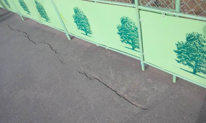
Shindo 6+ in Fujinomiya
The shaking was severe. On the Japan Meteorological Agency's seismic intensity scale, the earthquake registered Shindo 6+ in the city of Fujinomiya, at the base of Mount Fuji's southwestern slope. That rating -- equivalent to VIII (Severe) on the Mercalli intensity scale -- means concrete block walls crack, poorly reinforced structures can partially collapse, and people cannot remain standing without holding onto something. Roads cracked open in the town of Kannami. Across the region, 80 people suffered injuries, and power outages left neighborhoods in darkness. By the catastrophic standards of the Tohoku disaster still unfolding to the north, the damage was modest. But the location was what unnerved people. This was not a remote stretch of Pacific seafloor. This was Mount Fuji.
The Volcano Stirs
In the months following the earthquake, scientists detected something troubling beneath Fuji's slopes. Volcanic low-frequency earthquakes -- subtle tremors generated by the movement of magma or hydrothermal fluids deep underground -- increased in both frequency and intensity. A 2023 study published in Scientific Reports confirmed that the Shizuoka earthquake and subsequent crustal deformation had reactivated volcanic processes beneath the mountain. Stress changes in the order of 0.001 to 1 megapascal had been imposed on Fuji's magma reservoir -- values that researchers consider sufficient to trigger an eruption if the magma is primed to move. Fortunately, analysis indicated that the magma beneath Fuji did not have enough potential energy to erupt at that time. But the seismicity did not return to pre-earthquake levels, meaning something had changed permanently in the deep plumbing system of Japan's tallest and most famous peak.
Living in Fuji's Shadow
Mount Fuji last erupted in 1707, during the Hoei eruption, dropping volcanic ash on Edo (present-day Tokyo) over 100 kilometers away. The 2011 Shizuoka earthquake served as an uncomfortable reminder that the mountain is not extinct -- merely sleeping. In the years since, Japanese authorities have updated Fuji's eruption hazard maps and disaster response plans. The cities of Fujinomiya, Gotemba, and surrounding communities conduct regular evacuation drills. If Fuji were to erupt today, ash could blanket Tokyo's transportation infrastructure, and pyroclastic flows could threaten the densely settled foothills. The 2011 earthquake did not cause that eruption. But it did nudge the volcano's internal systems in ways that scientists are still monitoring, a quiet reminder that in this seismically restless nation, even the most serene-looking landmark carries the potential for dramatic change.
From the Air
Epicenter located at 35.27N, 138.58E on the south flank of Mount Fuji, at a depth of approximately 9 km. From the air, Mount Fuji (3,776m) dominates the landscape and serves as the primary visual reference. The earthquake epicenter was roughly 6 km southwest of the summit. Nearest airports: Mount Fuji Shizuoka Airport (RJNS) approximately 40nm south-southeast, Tokyo Haneda (RJTT) approximately 60nm east-northeast. The affected city of Fujinomiya sits at the southwestern base of Fuji. Note that the East Fuji Maneuver Area (military training zone) lies to the southeast of the epicenter -- check NOTAMs for restricted airspace in this area.