2021 Fukushima Earthquake
Ten days before the tenth anniversary of the worst earthquake in modern Japanese history, the same ocean struck again. At 23:07 on Saturday, February 13, 2021, a magnitude 7.3 earthquake ruptured deep within the Pacific plate beneath the seafloor off Fukushima Prefecture. Within minutes, three aftershocks of magnitude 5.3 rattled the region. The Japan Meteorological Agency soon classified the event as yet another aftershock of the 2011 Tohoku megathrust -- a seismic ghost that, a full decade later, was still redistributing stress through the fractured rock of the Japan Trench.
Ground Motion Beyond Measure
The shaking was extraordinary. At Yamamoto, Miyagi, instruments recorded a peak ground acceleration of 1,432 gals -- exceeding the 980 and 1,362 gals measured at Mashiki during the devastating 2016 Kumamoto earthquakes, which had been assigned the maximum Shindo 7 intensity. The JMA officially rated the 2021 Fukushima earthquake at Shindo 6 Upper, with maximum intensities recorded in both Fukushima and Miyagi prefectures, though the Earth Science and Disaster Prevention Research Institute suggested the shaking at Yamamoto may have actually reached Shindo 7. In Fukushima's Nakadori region, instruments captured Class IV long-period ground motion -- a level so severe that people cannot move without crawling and unsecured furniture topples. It was only the fourth time that intensity had been recorded since the scale was introduced in 2013.
A Coseismic Gap Revealed
The earthquake's tectonic story reads like a detective novel. Back-projection analysis revealed that the 2021 rupture occurred within a coseismic gap of the 2011 mainshock -- a patch of the subduction zone that had not slipped during the mega-earthquake. The enormous stress transferred by the 2011 event increased compressional strain within the Pacific plate beneath this gap, and a decade of accumulated pressure finally broke through. The rupture propagated along a fault striking roughly north-south over 45 kilometers. Seismologists later classified it alongside the April 2011 Miyagi earthquake and the subsequent March 2022 Fukushima earthquake as a seismic triplet, with the 2021 and 2022 events forming a doublet pair whose epicenters lay just 7 kilometers apart.
Darkness Across Tohoku
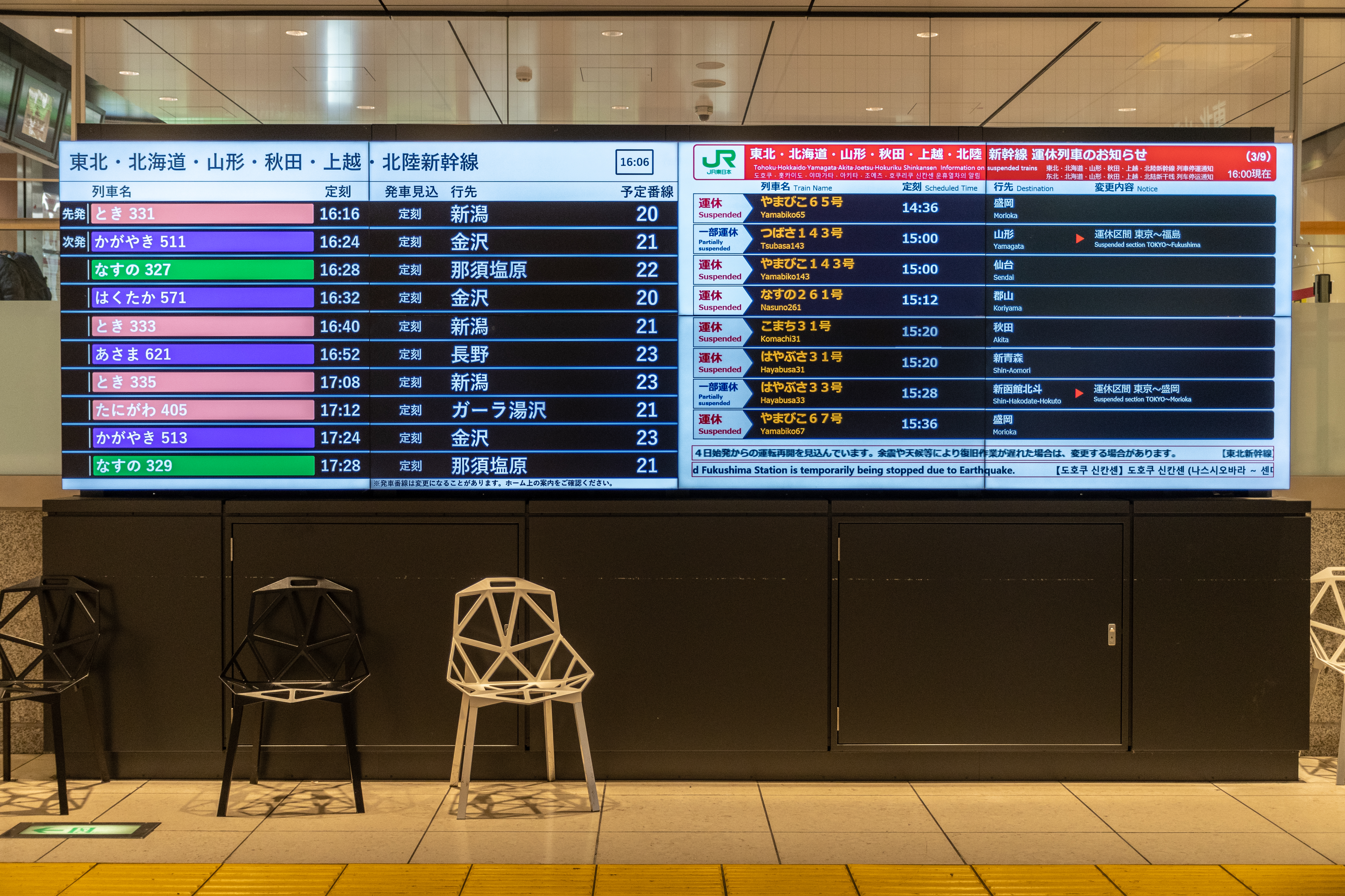
More than 950,000 homes lost power as multiple power plants went offline across the country. Shinkansen bullet train service on the Tohoku line was reduced to one train per hour between Tokyo and Nasushiobara. The Akita and Yamagata mini-Shinkansen lines were fully suspended, as were sections of the Tohoku Main Line and Joban Line. On the Joban Expressway, landslides buried sections of roadway and collapsed embankments, though no vehicles were trapped. At least 311 schools in Fukushima and Miyagi prefectures sustained damage -- cracked walls, broken windows, burst pipes -- prompting the closure of 71 schools. A landslide in Nihonmatsu partially buried the Ebisu Circuit race track, sweeping away cars and a two-story building.
Temples, Shrines, and Stone Lanterns
The Zuihoden Temple in Sendai's Aoba ward saw about 100 stone lanterns and tombstones collapse -- echoing the 2011 earthquake, when the same temple lost 200 lanterns and part of its stone wall. At the Inari Shrine in Fukushima City, a stone lantern fragment fell from five meters onto a parked car, crushing its roof. Shiroishi Castle suffered wall damage so severe that inspectors said entire sections would need replacement, at an estimated cost of 200 million yen. Across the region, the earthquake generated insurance claims and losses exceeding 138 billion yen. Three people died, including a man in Fukushima City who was found ten days later, suffocated beneath fallen furniture -- the first earthquake fatality in Japan since 2018.
Living on the Boundary
Prime Minister Yoshihide Suga initially reported no deaths -- a statement that proved false when the Fukushima City victim was discovered on February 23. The government set up crisis management operations within two minutes of the earthquake, and 70 evacuation centers opened across Fukushima Prefecture, sheltering roughly 200 people. TEPCO inspected the crippled Fukushima Daiichi reactors and found no immediate anomalies, though water levels in the damaged Units 1 and 3 dropped by tens of centimeters over the following week as cooling water leaked from quake-shifted containment structures. No change in radiation levels was detected. For the people of Tohoku, the 2021 earthquake was a grim anniversary gift -- proof that the Japan Trench's seismic cycle operates on timescales that mock human memory, and that the stress released in 2011 is still working its way through the deep architecture of the Pacific plate.
From the Air
Epicenter located at 37.72N, 141.76E, in the Pacific Ocean east of Fukushima Prefecture. The affected area extends from Sendai southward through coastal Fukushima and into Ibaraki Prefecture. Key visual landmarks include the Fukushima Daiichi nuclear complex with its distinctive decommissioning infrastructure, the reconstructed seawalls of the Tohoku coast, and the agricultural plains of inland Fukushima. Nearest airports: Sendai Airport (RJSS) approximately 55km to the north-northwest, Fukushima Airport (RJSF) approximately 85km to the west. Best viewed at 10,000-15,000 feet along the Pacific coastal corridor. The Joban Expressway and Tohoku Shinkansen corridor are visible as north-south linear features through the coastal lowlands. Winter weather in February can bring low clouds and occasional snow, though clear days offer excellent visibility of the coastline.