2025 Myanmar Earthquake
It was Friday prayer time when the ground broke. At 12:50 local time on 28 March 2025, the Sagaing Fault ruptured beneath central Myanmar with a magnitude of 7.7, sending seismic waves through Mandalay, Sagaing, and Naypyidaw in rapid succession. The shaking lasted 85 seconds. In that time, mosques full of worshippers collapsed, a dam burst, bridges fell into rivers, and the Irrawaddy valley -- one of Asia's oldest continuously settled landscapes -- was reshaped by the most powerful earthquake to strike Myanmar in over a century.
Eighty-Five Seconds on the Sagaing Fault
The rupture began near Sagaing Township, just west of Mandalay, and tore in both directions along the Sagaing Fault, a continental transform fault that runs the entire length of Myanmar for over 1,200 kilometers. Seismologists had identified the Meiktila segment -- stretching from Naypyidaw to Mandalay -- as a seismic gap, a section that had not produced a major earthquake since 1839. On 28 March, it broke completely. The rupture propagated at speeds exceeding the shear wave velocity, making this a supershear earthquake, and extended roughly 400 kilometers from Singu in the north to Kyauktaga in the south. Satellite data from Japan's Geospatial Information Authority revealed horizontal displacement of several meters along the fault trace. In Naypyidaw, a seismic station recorded a vertical peak ground acceleration of 1.07g -- meaning the ground lurched upward with a force exceeding gravity itself.
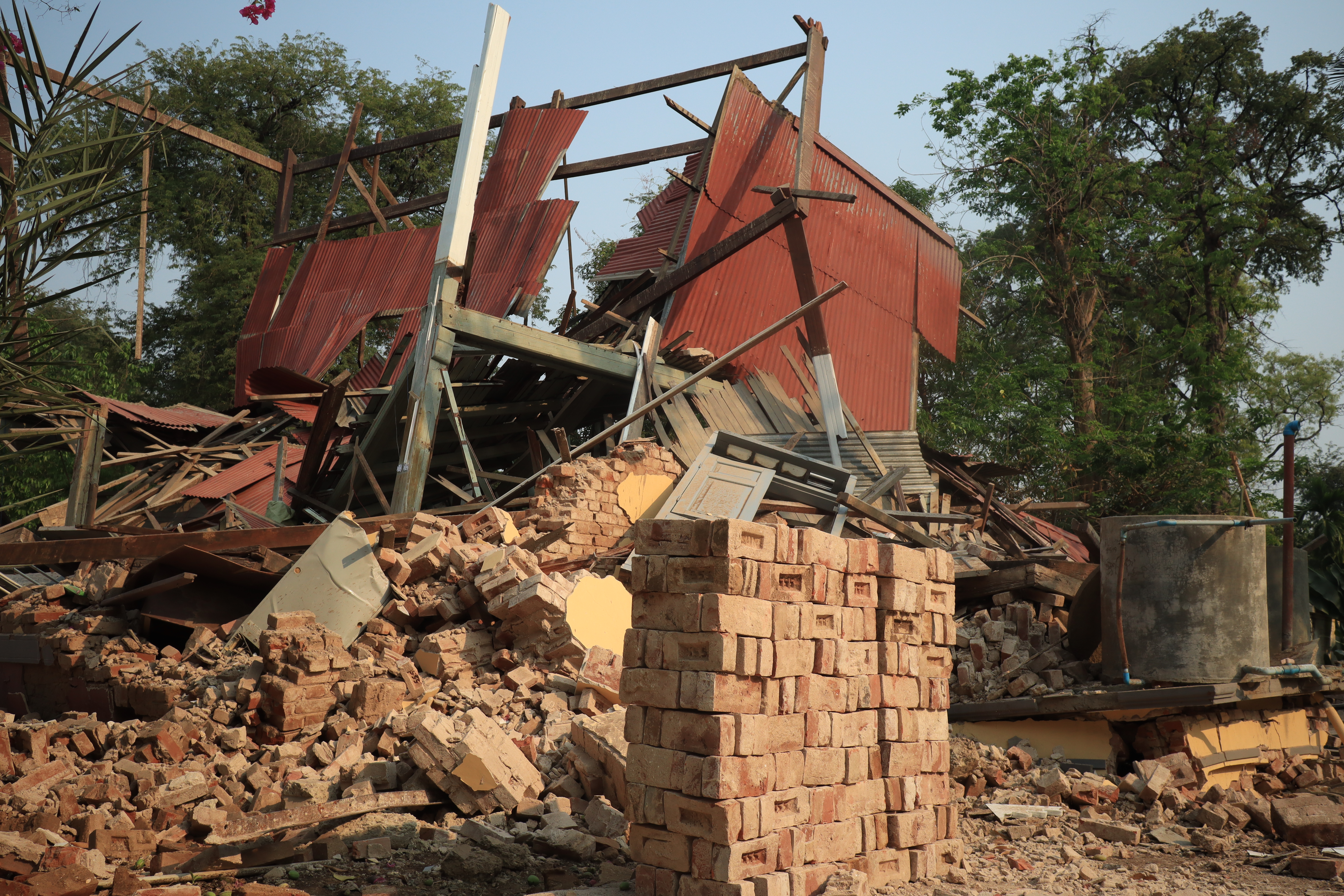
Cities Reduced to Rubble
The toll was staggering. In Mandalay, Myanmar's second-largest city, at least 1,870 people died. Buildings at Mandalay University collapsed or caught fire, trapping people inside. Over 600 monks sitting for examinations at U Hla Thein Temple were buried when the structure fell; 80 died. All 40 mosques in the city sustained damage, ten of them collapsing entirely and killing more than 400 worshippers. The Dokhtawaddy Bridge on the Yangon-Mandalay Expressway dropped into the Myitnge River with vehicles on it. In Sagaing City, an estimated 90 percent of structures were destroyed and roughly 1,000 people perished. The Ava Bridge and the city's fire station collapsed, cutting off the primary route for rescue teams. In Naypyidaw, the air traffic control tower at the international airport fell, killing six. Parliament buildings and military headquarters sustained heavy damage. The World Bank later estimated structural damage across Myanmar at approximately $11 billion, or 14 percent of the country's GDP.
A Disaster Within a War
The earthquake struck a country already fractured by civil war. Within minutes of the quake, jet fighters on a bombing run against rebel positions dropped ordnance on villages in Nawnghkio Township, adding to the destruction. From 28 March to 5 April, military airstrikes killed at least 68 civilians and rebel fighters. The People's Defence Force announced a partial ceasefire; the junta declared its own twenty-day truce on 2 April, but dozens of attacks followed. Aid delivery became a battlefield. Junta soldiers in Sagaing conducted security checks and blocked rescue operations. An Islamic cemetery was closed due to fighting, forcing the transport of Muslim dead to Mandalay for burial. The military regime fired warning shots at Chinese relief trucks in Shan State. Human rights organizations, including Amnesty International, accused the junta of selectively allocating assistance, directing resources to Mandalay and Naypyidaw while restricting access to resistance-held regions in Sagaing and Shan.
The Weight of Aftermath
In the days following, Mandalay's residents dug through rubble with their bare hands. The city's general hospital overflowed, treating patients outdoors. Fires swept through three wards, reducing Maha Aungthan West entirely to ash. Roads buckled, power failed, and fuel shortages paralyzed transportation. Decomposing bodies accumulated at Sagaing's overwhelmed morgue, left in the open because the power outage disabled refrigeration. Cremators could not keep pace. The United Nations warned of potential cholera and dengue outbreaks as clean water ran short. In Bangkok, approximately 1,029 kilometers to the southeast, a 33-story office tower under construction in Chatuchak district collapsed, killing 95 people -- the soft marine clay beneath the city had amplified the distant seismic waves and set tall buildings swaying for five full minutes. It was the deadliest earthquake globally since the 2023 Turkey-Syria earthquakes, and its aftershocks continued for weeks, collapsing additional structures in Mandalay and breaching a dam in Tatkon Township on 13 April.
History Repeating Along the Same Fault
The Sagaing Fault had done this before. In 1839, a magnitude 7.9 earthquake ruptured the same Meiktila and Sagaing segments, devastating the royal capital of Inwa so thoroughly that the court relocated to Amarapura. Nearly every brick building was reduced to rubble, the Irrawaddy River briefly reversed its flow, and villages were swallowed by liquefaction. In 2025, the fault broke the same stretch again, plus more. The 2025 rupture extended further south, overlapping zones that had moved in 1929 and 1930 as well. Seismologists had predicted this. A 2011 study by Nobuo Hurukawa and Phyo Maung Maung identified the Meiktila gap and concluded it could produce a magnitude 7.9 earthquake if it fully ruptured. Fourteen years later, it did exactly that. The question now is not whether central Myanmar will face another such event, but when -- and whether the cities rebuilt atop this fault will be any better prepared.
From the Air
Epicenter at approximately 22.01N, 95.92E in the Sagaing Region, near the Sagaing-Mandalay border. The Sagaing Fault trace runs roughly north-south and is visible in terrain features along the Irrawaddy River valley. Mandalay International Airport (VYMD) is the nearest major field. Extensive structural damage visible across Mandalay, Sagaing City, and along the Yangon-Mandalay Expressway corridor. The collapsed Dokhtawaddy and Ava bridges are notable landmarks of destruction. Best observed from 5,000-10,000 feet AGL to appreciate the scale of the affected zone.