23 de Enero
The name is a date: January 23, 1958, the day Venezuela's military dictator Marcos Perez Jimenez fled the country in a plane loaded with suitcases. Within hours, crowds poured into the streets of western Caracas, and the housing complex the dictator had built to burnish his own legacy was rechristened with the date of his humiliation. Originally called "Urbanization December 2" -- commemorating the coup that had brought Perez Jimenez to power -- the neighborhood became 23 de Enero overnight, a place whose very name is an act of political reversal.
A Dictator's Gift, Repurposed
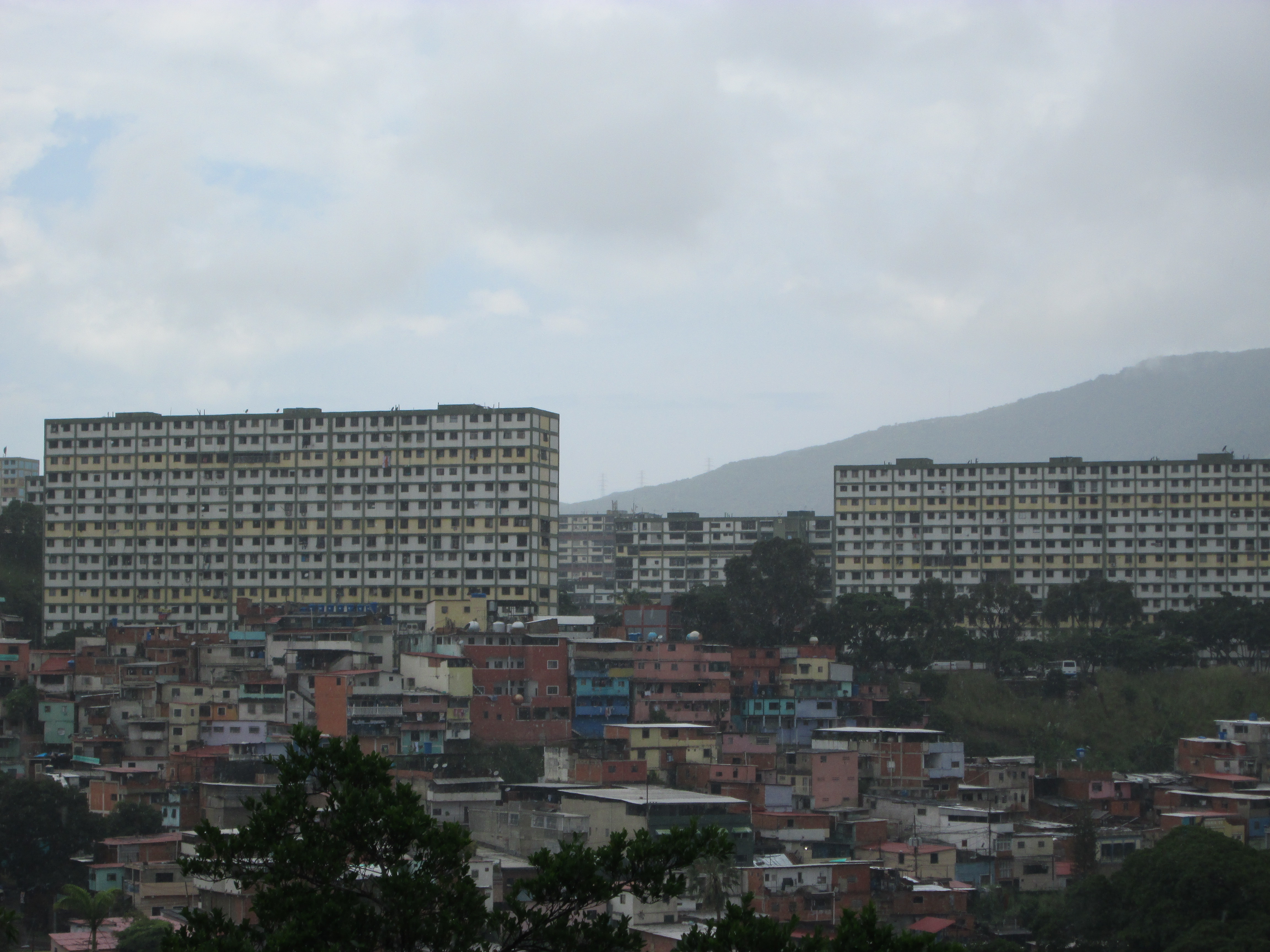
In the early 1950s, Perez Jimenez commissioned architect Guido Bermudez to design a massive housing complex modeled on Le Corbusier's Cite Radieuse, the same modernist template used for the Tlatelolco housing project in Mexico City. The concrete superblocks rose on the hills northwest of Caracas, meant to house the capital's middle and lower classes in orderly, state-planned apartments. It was a showcase project for a regime that wanted to appear modern and benevolent. But the dictator's name was barely dry on the dedication plaques before he was gone. His successor, Romulo Betancourt, renamed the complex and the surrounding area to mark what Venezuelans consider the beginning of their democratic era. In 1966, 23 de Enero was formally separated from the Sucre Parish and designated as its own parish, a recognition of both its growing population and its distinct political identity.
Ground Zero for Upheaval
If Venezuelan political history has a recurring stage, it is 23 de Enero. When the Caracazo erupted on February 27, 1989 -- a wave of protests, riots, and deadly military crackdowns triggered by austerity measures under President Carlos Andres Perez -- this neighborhood was among the first in the capital to ignite. Looting and confrontations between residents and security forces played out in the same tower blocks that had been built to project social order. Three years later, Hugo Chavez planned his 1992 coup attempt from within the parish, using the Montana Barracks as his staging ground. The coup failed, but it launched Chavez's political career. Since March 15, 2013, his remains have rested in the Museum of the Bolivarian Revolution inside those same barracks -- the very spot from which the failed uprising was launched, now transformed into a shrine.
Life Between the Superblocks
Nestled in a series of hills adjacent to the Catia and Sucre parishes, 23 de Enero is a predominantly residential area divided into sectors with names that read like a small-town directory: el Observatorio, La Piedrita, La Silsa, Mirador, El Saman, La Canada. As of 2009, roughly 84,650 people lived here, many of them descendants of squatters who occupied the complex after the dictator's overthrow in 1958. The original Le Corbusier-inspired towers stand alongside informal settlements that have grown organically over decades. Major recreation areas break up the dense urban fabric, and the Cipriano Castro Barracks, home to elements of the Venezuelan Army, sits in the vicinity alongside the headquarters of the National Militia.
Order on Its Own Terms
23 de Enero carries a reputation for violence, robbery, and drug trafficking that precedes anyone who visits. But the reality is more complicated than the headlines suggest. Groups known as colectivos -- particularly the Tupamaros -- patrol the neighborhood's streets, some of their members wearing armbands emblazoned with the Venezuelan flag and carrying firearms and radios. Whether these groups combat crime or contribute to it depends on whom you ask. Residents have claimed that the colectivos reduced crime through heavy penalties, a system of rough justice they attribute to the influence of Hugo Chavez. The parish remains a place where the Venezuelan state's authority competes with local power structures that emerged from decades of political struggle, creating a neighborhood that governs itself by rules outsiders do not always understand.
From the Air
23 de Enero sits at 10.508N, 66.931W in the hills northwest of central Caracas, Venezuela. From the air, look for the distinctive grid of modernist concrete superblock towers on the hillsides west of Miraflores Palace, the presidential residence. The neighborhood's tower blocks contrast sharply with the surrounding informal settlements. Nearest airport: Simon Bolivar International Airport (SVMI/CCS) approximately 20km north, across the coastal mountains. Maiquetia airport sits on the Caribbean coast side. Recommended viewing altitude: 3,000-5,000 feet for the best perspective on the superblock layout.