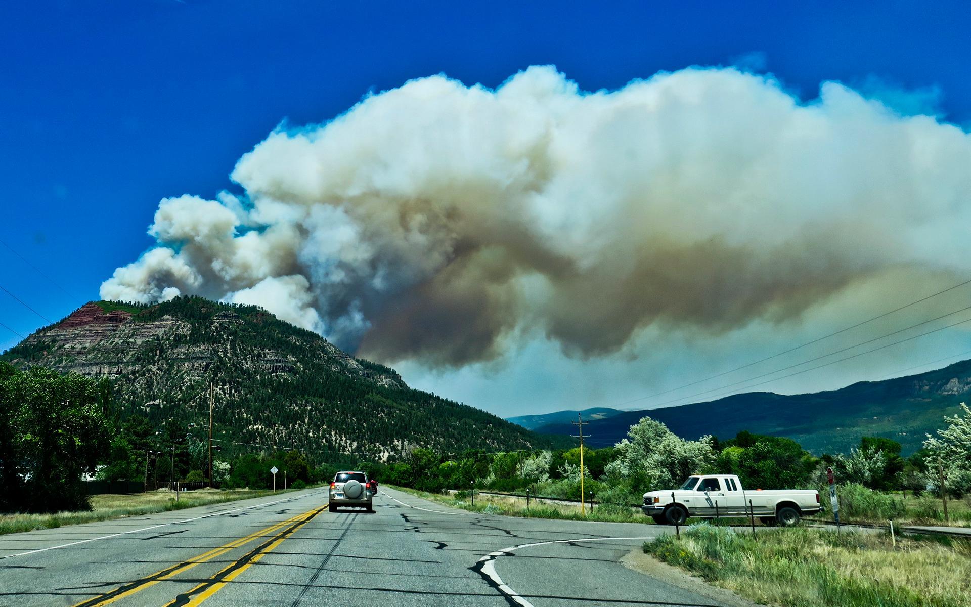
416 Fire
Silverton, Colorado cancelled its Fourth of July fireworks in 2018. For a tiny mountain town that depends on summer tourism like oxygen, the decision was unthinkable -- and unavoidable. The San Juan National Forest was burning. The 416 Fire, allegedly sparked by embers from a coal-burning steam locomotive on the Durango and Silverton Narrow Gauge Railroad, had been consuming the landscape north of Durango since June 1. By the time it was contained, the 416 Fire and its companion Burro Fire had burned over 54,000 acres and cost more than $43 million to fight, ranking among the largest wildfires in Colorado history.
Sparks from the Past
The Durango and Silverton Narrow Gauge Railroad is a beloved relic, a coal-burning steam train that has carried tourists through the spectacular Animas River canyon since 1882. But on June 1, 2018, that heritage became a liability. The 416 Fire ignited around 10:00 a.m. adjacent to the railroad tracks, approximately north of Durango and west of Highway 550. Federal investigators later alleged that embers from the locomotive started the blaze, and the U.S. government filed a lawsuit seeking $25 million in firefighting costs, penalties, and legal expenses. By the morning of June 2, the fire had expanded into San Juan National Forest. Highway 550 was closed. Evacuation orders went out for residents near Baker's Bridge, where 825 structures were threatened. The Burro Fire followed on June 8, igniting on the opposite side of the Hermosa Creek Wilderness Area.
A Summer Under Siege
Through June, the fire grew relentlessly. Drought conditions and above-average temperatures fed the flames. Southerly winds pushed fire along ridgelines toward the community of Hermosa, triggering pre-evacuation orders. Aerial support joined ground crews battling the blaze. By July 1, the combined fires had consumed over 51,000 acres and were only 37 percent contained. The fire forced the closure of Purgatory Ski Resort, the Durango and Silverton Narrow Gauge Railroad, and the entire San Juan National Forest. Highway 550, the lifeline connecting Durango to Silverton, suffered sporadic closures. Smoke blanketed communities along the corridor. Though no structures were destroyed by the fire itself, heavy monsoon rains that followed triggered floods in the burn scars, damaging homes and businesses. The landscape had been fundamentally altered.
An Economy in Ashes
The economic toll rippled across southwest Colorado. Silverton, a town of fewer than 700 residents that swells with tourists each summer, lost its primary attraction when the railroad shut down. The cancelled Fourth of July fireworks show, which normally draws thousands of visitors, was a symbolic blow. Durango's tourism industry suffered as trails, forests, and the railroad all went dark simultaneously. Highway closures disrupted commerce across the region. State officials began documenting financial losses. Businesses that survived the fire still faced the aftermath: when monsoon season arrived, rain sheeted off the scorched, barren hillsides and flooded the valleys below. The damage from post-fire flooding sometimes exceeded the fire's direct impact.
Reckoning on the Rails
The legal aftermath stretched for years. Federal authorities sued the Durango and Silverton Narrow Gauge Railroad, and local residents filed their own lawsuits. On March 31, 2022, the railroad reached two settlements: $20 million to the federal government along with a commitment to institute a fire mitigation program, and an undisclosed amount to home and business owners affected by the fire and subsequent floods. The railroad itself adapted. The historic steam locomotives that had burned coal since the 19th century were converted to burn oil, eliminating the ember risk that had ignited the catastrophe. It was a practical concession -- the romance of coal smoke traded for the survival of the railroad and the forests it passes through. The 416 Fire left scars visible from the air: ghostly grey hillsides where dense forest once stood, slowly greening as the San Juans begin their long recovery.
From the Air
Located at 37.46N, 107.81W in the San Juan National Forest, north of Durango, Colorado. Burn scars from the 416 Fire are visible from altitude as lighter-colored patches on otherwise forested mountainsides between Durango and Silverton along the Highway 550 corridor. The Animas River valley runs through the burn area. The Durango and Silverton Narrow Gauge Railroad tracks follow the river. Nearest airports: KDRO (Durango-La Plata County Airport), Purgatory Resort is visible to the north. Recommended viewing altitude: 8,000-12,000 feet AGL for burn scar visibility.