Abel Tasman National Park
The beach appears around a headland, a crescent of golden sand backed by forest that looks like it's never been touched. The water is turquoise, absurdly so, the color that travel brochures exaggerate but that here exists without enhancement. You've walked three hours from the last beach, or paddled across the bay in a sea kayak, or arrived by water taxi that dropped you on the sand and motored away, leaving you in a silence broken only by birdsong and the gentle lap of wavelets on shore. This is Abel Tasman National Park - New Zealand's smallest national park at 22,000 hectares, but perhaps its most perfect. No roads enter the park. No cars disturb the trails. The Coast Track is one of New Zealand's Great Walks, a 51-kilometer traverse from Marahau to Wainui Bay that can be done in three to five days, camping or hutting at beaches that look like postcards come to life. The park was created on December 18, 1942 - exactly 300 years after Abel Tasman, the Dutch explorer for whom it's named, first anchored in the bay and encountered the Maori people who would drive him away.
The Golden Coast
The beaches of Abel Tasman are not white but gold - a warm, honey-colored sand derived from the granite that underlies the park. Torrent Bay, Anchorage, Bark Bay, Onetahuti, Awaroa - each name marks a crescent of that golden sand, each accessible only by the track that links them or by the boats and kayaks that work the coast. The water is remarkably calm, protected by the curve of the bay from the Tasman Sea's rougher moods. Swimming is safe almost everywhere; the surf is minimal, the currents gentle, the water surprisingly warm in summer.
The coastal track links these beaches with well-maintained paths through coastal rainforest, rising occasionally to cross headlands before dropping to the next bay. Some sections are tide-dependent - at Torrent Bay and Awaroa, estuaries must be crossed at low tide or circumnavigated on longer tracks. This adds an element of planning that most casual hikes lack: consult the tide tables, time your departures, and you'll walk across empty sand where high tide would have you scrambling through forest.
The Water Taxi Economy
No roads means no cars, but it doesn't mean isolation. A fleet of water taxis operates from Marahau and Kaiteriteri, running schedules as reliable as any bus service. Want to walk just the northern section? The water taxi drops you at Bark Bay and picks you up at Totaranui. Want to skip ahead to the beach with the best swimming? Tell the driver. The boats make walking Abel Tasman remarkably flexible - you don't have to commit to the entire track, and you don't have to retrace your steps.
Kayak rentals offer another option: paddle your own way between beaches, camping at designated sites, exploring the marine reserve around Tonga Island where fur seals haul out on the rocks. The multi-day kayak trip is a different experience than walking - slower in some ways, more connected to the water, with the possibility of seal encounters and beach landings impossible from the track. Some operators combine both: kayak one direction, walk the other, water taxi back to the start.
Cleopatra's Pool
About an hour's walk inland from the coast, hidden in the forest where few casual visitors venture, Cleopatra's Pool offers one of the park's stranger delights: a natural waterslide carved by centuries of running water over smooth rock. The pool at the bottom is deep enough for swimming, cold enough to shock, and beautiful enough to justify the detour. The rock slide itself is lined with moss that somehow makes the descent smoother; you can slide for meters before splashing into the pool below.
The pool is one of several inland attractions that reward walkers who venture beyond the beach-to-beach circuit. Cascade Falls, about 90 minutes from Torrent Bay, plunges through forest that feels primeval. The Falls River bridge is an engineering marvel spanning a gorge between Bark Bay and Torrent Bay. These interior trails are steeper, less traveled, and offer glimpses of the park that most visitors miss in their focus on the coastal route.
The Tidal Crossings
Twice on the Coast Track, the trail disappears into tidal estuaries that can only be crossed near low tide. At Torrent Bay, the shortcut across the estuary takes 25 minutes; the high-tide track around takes nearly two hours. At Awaroa, the crossing is unavoidable - there is no high-tide alternative, so you must time your arrival to the tides or wait on the beach until the water drops.
This tidal dependence gives the track a rhythm that most hiking routes lack. You check the tables, plan your days around the ebb and flow, and sometimes find yourself with hours to kill on a beach waiting for the water to drop. The waiting is not unpleasant - you're on a golden beach, after all, with swimming and sunshine and nowhere to be except across the estuary when the sand finally appears. But it requires attention, planning, awareness of the natural cycles that govern life on the coast.
The Anniversary Park
Abel Tasman sailed into these waters on December 18, 1642, the first European to reach New Zealand. His encounter with the Maori was brief and violent - four of his crew were killed before he could land, and he sailed on without setting foot on shore. The bay where the encounter occurred, just north of the current park boundary, still bears the name he gave it: Murderers Bay (now Golden Bay, renamed for obvious tourism reasons).
Exactly 300 years later, on December 18, 1942, the park was created - a deliberate anniversary, a conscious reclaiming of the explorer's legacy for conservation rather than colonization. The park has grown since then, from 15,000 hectares to over 22,000, as adjacent lands have been added and regenerating forest has recovered from earlier logging. It remains New Zealand's smallest national park, but the size is misleading. Measured by visitors, by beauty, by the precision of its beaches and the clarity of its water, Abel Tasman exceeds parks many times its size. The Dutch explorer never walked these tracks. The Maori knew them long before he arrived. Now they belong to everyone willing to go on foot.
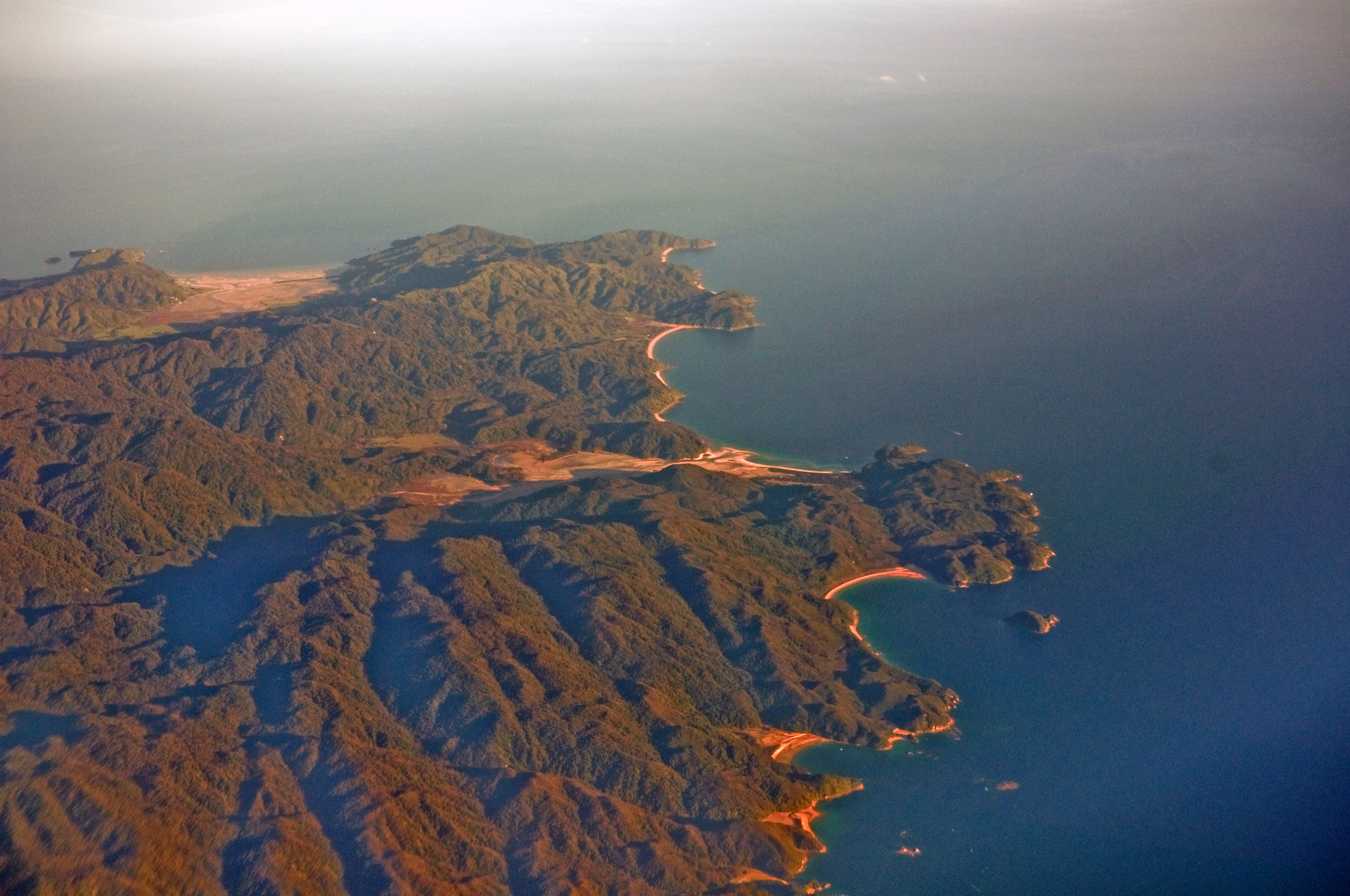
From the Air
Located at 40.83°S, 172.90°E on the northern tip of New Zealand's South Island, between Tasman Bay and Golden Bay. The park has no internal airports or roads - access is by foot, boat, or helicopter only. Nelson (NSN) is the nearest commercial airport, 67km by road from Marahau (southern entry point). The park is roughly 22,000 hectares of coastal terrain visible from altitude as a green forested coastline with distinctive golden beaches in protected bays. Look for the indented coastline between Kaiteriteri and Totaranui. The Coast Track (51km) follows the shore; the Inland Track crosses the hilly interior. Tonga Island Marine Reserve is offshore. Weather is among the best in New Zealand - the region receives 2,000+ hours of sunshine annually. Tasman Bay and Golden Bay are generally calm. Private landing at Awaroa is possible (airstrip exists, but permission required). The park is closed to vehicles; water taxis operate from Marahau and Kaiteriteri.