Adonara: The Five Shores and the Feuding Brothers
The division was old before the Europeans arrived. Long before Portuguese missionaries set foot on neighboring Solor in the sixteenth century, the people of Adonara had already sorted themselves into two camps: the Paji, who lived along the coasts and were open to outside influences, and the Demon, who settled the mountainous interior and kept to older ways. When Islam reached the archipelago, the Paji absorbed it. When the Portuguese came with their crosses and their cannons, the Demon fell under their orbit. This was not mere religious preference -- it was a social architecture that organized everything from trade alliances to warfare, from marriage patterns to the control of territory. Adonara, the tallest island in the Solor Archipelago at 1,659 meters, carried this fracture line through centuries of colonial maneuvering, and traces of it remain visible today.
The Five Shores
The Paji areas on Adonara contained three principalities: Adonara proper, centered on the north coast, and Terong and Lamahala along the south coast. Together with two principalities on neighboring Solor -- Lohayong and Lamakera -- they formed a league called Watan Lema, meaning "the five shores." This was not a nation in any modern sense but a confederation of coastal trading communities bound by mutual interest and a shared wariness of the mountain-dwelling Demon. In 1613, the Watan Lema allied with the Dutch East India Company, a partnership confirmed by treaty in 1646. The alliance was practical rather than sentimental. The Dutch offered protection from the Portuguese, who held the town of Larantuka on the eastern tip of Flores and exercised influence over the Demon territories. The Adonara principalities were not, however, obedient Dutch subjects. They feuded with the Portuguese regularly and followed Dutch instructions only when it suited them -- a pattern of selective cooperation that would define the island's relationship with colonial power for the next three centuries.
A Dynasty on a Volcanic Ridge
The rulers of Adonara proper -- the rajas of the northern principality -- built a dynasty that can be traced from the mid-seventeenth century through Indonesian independence. The lineage begins with Foramma around 1650 and runs through more than a dozen named rulers, each inheriting a position that carried real authority over the island and, at times, over parts of eastern Flores and neighboring Lembata. The succession was not always smooth. Raja Eke was killed by mountain people in 1688. Raja Begu was killed in 1850. Bapa Ana, who served as regent from 1930, was condemned to life imprisonment in 1935 and exiled to Kupang. The last in the line, Mohamad Eke, held the title until the Indonesian government abolished the principalities in 1962 -- a sweep of the bureaucratic pen that ended a system of governance older than the Dutch Republic. Some local officials still trace their authority back to these rajas, a thread of legitimacy that runs deeper than any constitution.
Between Two Empires
Adonara's position between the Portuguese sphere in Larantuka and the Dutch sphere in the Solor islands made it a contested space for centuries. The Demon territories in the mountains owed allegiance to the Portuguese-backed principality of Larantuka, while the Paji coast looked toward Dutch Batavia. In the nineteenth century, the northern raja of Adonara strengthened his position considerably, extending his authority as overlord of parts of eastern Flores and Lembata. But the colonial reshuffling was relentless. Portugal ceded Larantuka and its dependencies to the Netherlands in 1859 under the Treaty of Lisbon, collapsing the old Demon-Portuguese alliance into the broader structure of the Dutch East Indies. The people of Adonara, who spoke the Lamaholot language and shared deep cultural ties with communities across the Solor Archipelago, found their political boundaries redrawn by diplomats in European capitals who had never seen the islands. Independence in 1945 brought another rearrangement. The principalities survived until 1962, ghosts of a political order that had outlasted three colonial regimes.
Ile Boleng and the Quiet Island
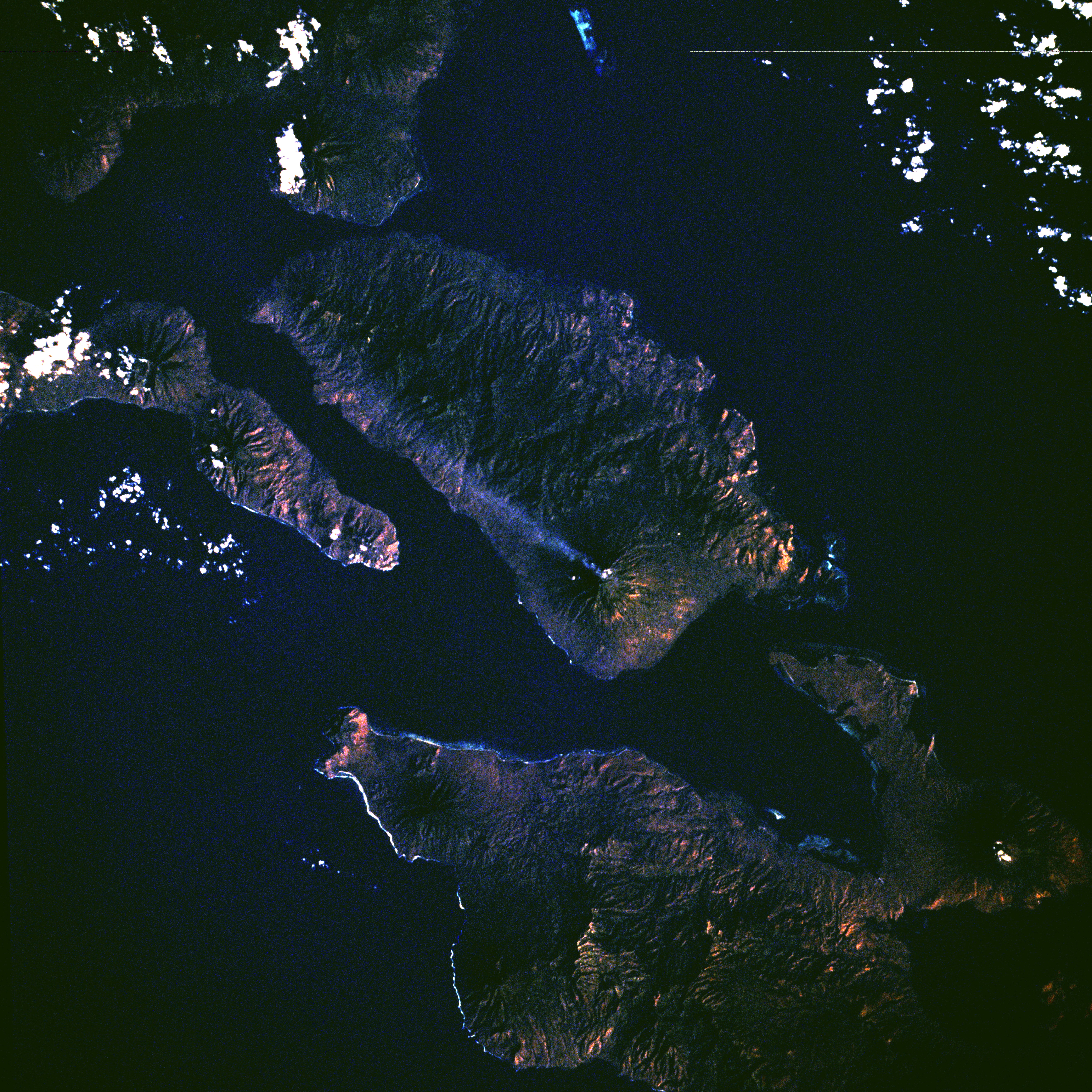
Adonara's volcano, Ile Boleng, rises to the island's full height of 1,659 meters and is one of the most active in the Lesser Sunda Islands, with its last eruption recorded in 1991. The crater at the summit is a reminder that the island's geology is as restless as its history. Yet Adonara today is quiet in ways that matter. The only urban area is the town of Waiwerang and its neighboring villages of Lamahala Jaya, Terong, and Waiburak on the south coast. There is no single administrative center -- each of the island's eight districts maintains its own seat, all subordinate to the regency capital of Larantuka across the strait on Flores. Getting to Adonara requires a flight from Jakarta to Kupang, a ferry to Larantuka, and then a boat crossing. Many coastal villagers make their living through pearl diving. Slash-and-burn farming persists in the interior, where forest is cut and burned to create fields that are cultivated for a few years and then abandoned as farmers move to new ground. The landscape renews itself slowly, the way it always has -- volcanic soil feeding new growth on slopes shaped by eruptions and centuries of human use.
From the Air
Adonara lies at approximately 8.33S, 123.17E in the Solor Archipelago, east of Flores. From altitude the island is clearly visible as a tall, roughly triangular landmass flanked by Solor to the south and Lembata to the east, with narrow straits separating them. Ile Boleng volcano dominates the profile at 1,659 meters (5,443 ft). The nearest airport is Gewayantana Airport (WATG/LKA) at Larantuka on the eastern tip of Flores, connected by boat to Adonara. Frans Seda Airport (WATC/MOF) at Maumere is the nearest larger facility. No airstrip exists on Adonara itself. The straits between islands can generate turbulence due to thermal effects and channeled winds. Tropical weather patterns apply, with wet season November-March.