Aerial Lift Bridge
Every November 10, a sequence of horn blasts echoes across Duluth Harbor: long-long-long-short-short. The Aerial Lift Bridge is saluting the SS Arthur M. Anderson as the lake freighter enters the canal, and the Anderson answers back. The exchange, known as the Master Salute, honors the crew of the SS Edmund Fitzgerald, which sank with all hands in Lake Superior on that date in 1975. The Anderson was the last vessel to make contact with the Fitzgerald before she went down, and the first on scene to search for survivors. There were none. That a bridge participates in this annual act of maritime mourning tells you something about what the Aerial Lift Bridge means to Duluth. It is not just infrastructure. It is the city's front door, its most photographed landmark, and a working piece of history that has been rising and falling over the ship canal since 1905.
The Problem of the Sand Spit
The bridge exists because Duluth created an island. In 1870-1871, the city dredged a ship canal through Minnesota Point, a miles-long sand spit that separates the harbor from Lake Superior. The natural mouth of the Saint Louis River lay far to the southeast, split between Minnesota and Wisconsin -- too distant and shallow for the commercial shipping traffic that Duluth's boosters envisioned. Cutting the canal solved the harbor access problem but stranded the residents of what became Park Point on a newly created island. Summer ferries worked well enough, but Lake Superior ice made winter crossings treacherous. A swinging footbridge was tried but deemed rickety and unsafe. In 1892, the city held a design contest. Engineer John Low Waddell proposed a vertical lift bridge, but the War Department objected to the design, fearing it would obstruct navigation. The project was scrapped. Waddell's plan was later built in Chicago as the South Halsted Street Bridge, which lasted until 1932.
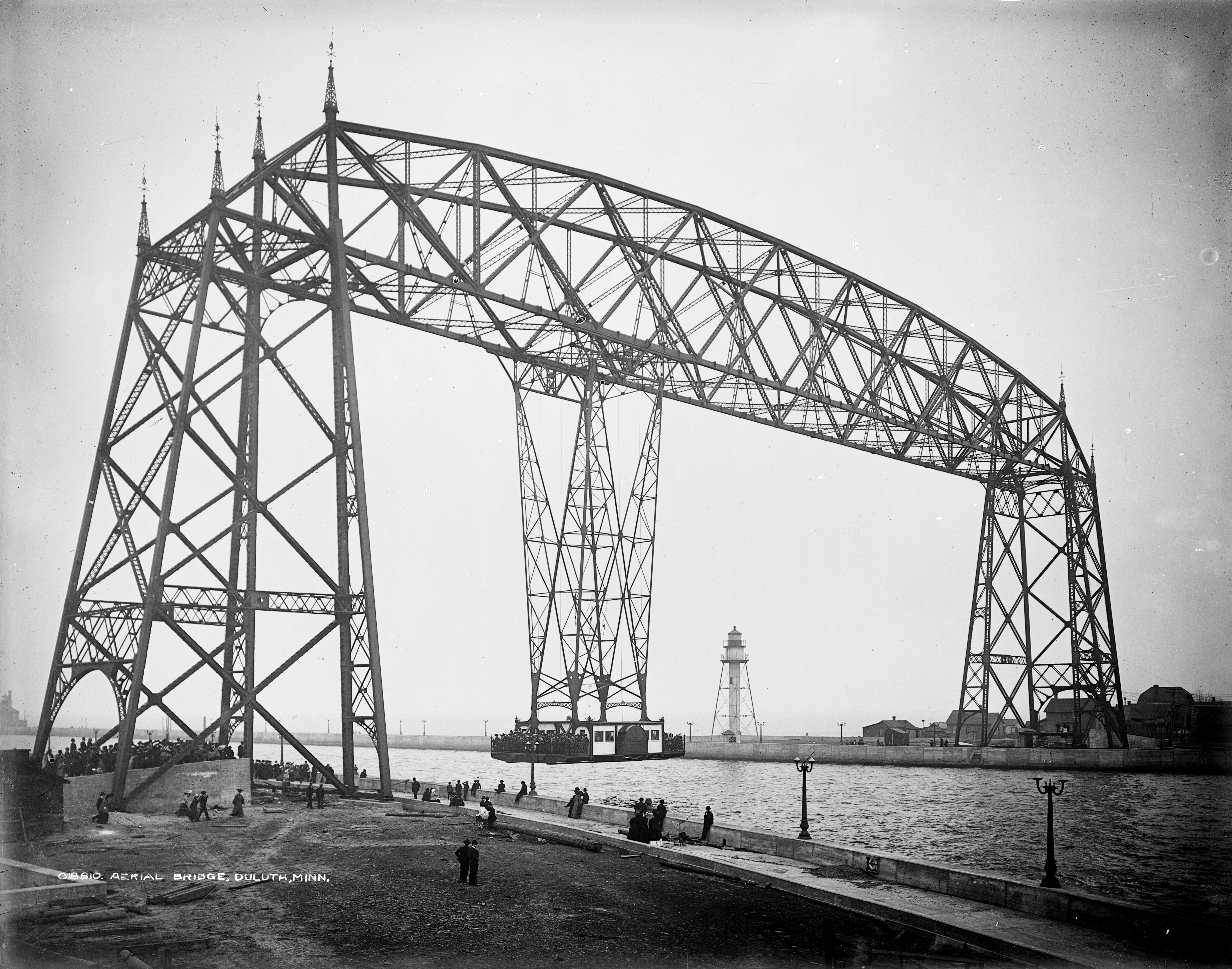
The Gondola in the Sky
The solution that actually got built was something few Americans had ever seen. City engineer Thomas McGilvray drew up plans for a transporter bridge -- a high steel framework spanning the canal, from which a gondola car hung on cables and shuttled back and forth beneath the structure. The concept had first been demonstrated at Bilbao's Vizcaya Bridge in 1893 and in France in 1898. Duluth's version, completed in 1905, became the first transporter bridge in the United States. The gondola had a capacity of 60 short tons and could carry 350 people along with wagons, streetcars, or automobiles. A crossing took about one minute, with the car running every five minutes during peak hours. Only one other transporter bridge was ever built in America: Chicago's Sky Ride, constructed for the 1933 World's Fair. Duluth's original span lasted until 1929, when the decision was made to convert it to something more practical.
The Lift That Never Stops
Between 1929 and 1930, the transporter bridge was rebuilt as a vertical-lift span -- the road deck itself now rises between the steel towers to let ships pass beneath. The conversion preserved the original tower framework while replacing the gondola mechanism with a counterweighted deck that can reach its full height in about a minute. The bridge rises approximately 5,000 times per year, a frequency driven by the steady flow of lake freighters, ocean-going vessels, and pleasure craft through the Duluth Ship Canal. As each ship passes, there is a customary exchange of horn blasts. The bridge's horns are two Westinghouse Airbrake locomotive horns, and the most common signal is the Captain's Salute: long-short-short. The bridge was added to the National Register of Historic Places on May 22, 1973, and designated a National Historic Civil Engineering Landmark by the American Society of Civil Engineers in 2017.
Canal Park's Steel Sentinel
The Aerial Lift Bridge dominates the Canal Park skyline, its twin steel towers framing the view of Lake Superior from Duluth's most visited waterfront district. Ship-watching from the canal is a local tradition and a tourist draw: spectators line the piers to watch enormous lake freighters glide beneath the raised span, close enough to read the hull markings. The United States Army Corps of Engineers maintains a maritime museum nearby, adding historical context to the parade of vessels. The bridge connects Canal Park to Park Point, still a residential neighborhood on Minnesota Point where homes line the narrow sand spit between the harbor and the open lake. For residents, the bridge is a daily commute -- one occasionally interrupted when a thousand-foot ore carrier needs to pass through. For everyone else, it is the defining image of Duluth: steel against water, commerce meeting the cold vastness of Superior.
From the Air
Located at 46.779°N, 92.093°W at the entrance to Duluth Harbor, spanning the Duluth Ship Canal where it cuts through Minnesota Point (Park Point). The bridge's twin steel towers are a prominent visual landmark from the air, especially when the span is raised. Duluth International Airport (KDLH) is approximately 7 nm northwest. The bridge sits at the junction of the harbor and Lake Superior -- the long narrow sand spit of Minnesota Point extends southeast from the bridge, clearly visible from altitude. Best viewed at 1,500-3,000 feet AGL for detail of the bridge structure and ship traffic. The Canal Park waterfront district is immediately west of the bridge. Lake freighter traffic through the canal is frequent during shipping season (March-January).