Aiguestortes i Estany de Sant Maurici National Park
The name translates roughly as "the winding streams and Saint Maurice's lake," and it is one of those rare places where the name actually captures the experience. Aiguestortes i Estany de Sant Maurici is Catalonia's only national park, a 141-square-kilometer core of Pyrenean wilderness where streams twist through alpine meadows so extravagantly that the Catalan word for their meandering -- aiguestortes -- became the park's identity. Nearly 200 lakes dot the landscape, most of them gouged out by glaciers that retreated thousands of years ago, leaving behind a terrain so saturated with water it seems to breathe.
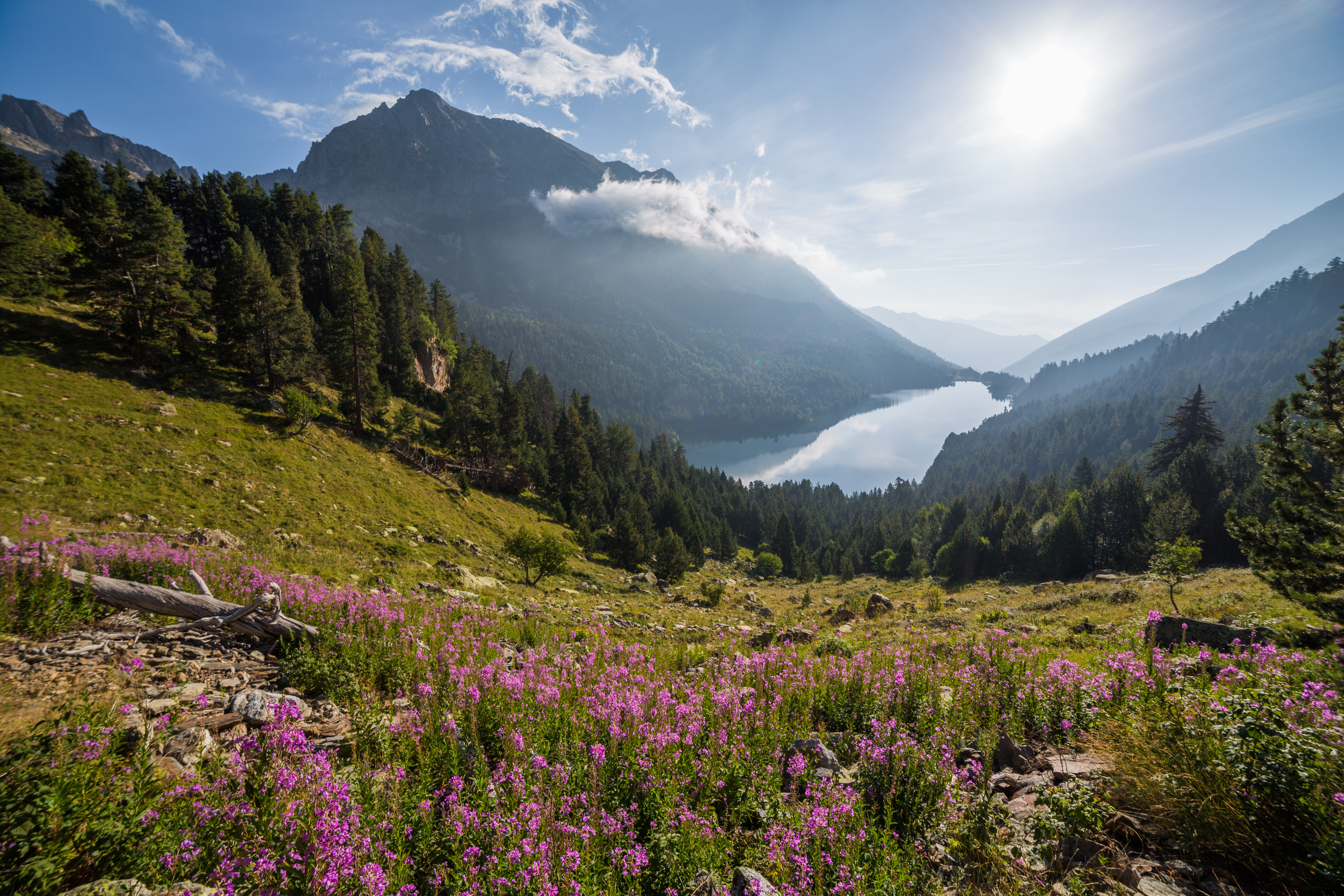
A Landscape of Lakes
The numbers alone are striking: nearly 200 lakes within the park and its surrounding buffer zone, scattered across an elevation range from 1,600 to 3,000 meters. Most are glacial tarns, their basins carved during the Pleistocene and filled by snowmelt and rainfall ever since. Sant Maurici, the lake that shares billing in the park's name, sits at the eastern entrance, its surface reflecting the twin granite spires of Els Encantats -- the "enchanted ones" of Catalan legend. The western side of the park holds the Aiguestortes plain, where the Riu de Sant Nicolau winds through flat meadows in sinuous loops before dropping into the valley below. Since 2006, the entire park has been designated a Ramsar wetland site, an acknowledgment that this is not merely scenic landscape but functioning aquatic ecosystem.
The Vertical Forest
Altitude organizes everything here into bands. The lower montane zone holds deciduous forests and Scots pine. The upper montane thickens with beech and silver fir. In the subalpine zone, mountain pine dominates, its gnarled forms marking the transition from forest to rock. Above the tree line, alpine meadows host the wildflowers and grasses that survive freezing temperatures, thin soil, and intense ultraviolet light. The fauna follows the same vertical logic. Pyrenean chamois scale the steepest terrain, their hooves gripping rock faces that look vertical from below. Brown bears -- reintroduced and still rare -- move through the lower forests. Marmots whistle from boulder fields in the subalpine zone. Overhead, lammergeiers ride thermals along the ridgelines, and golden eagles survey territories measured in square kilometers.
Chariots of Fire
The park's nine guarded mountain refuges -- Amitges, Colomers, Colomina, Ernest Mallafre, Estany Llong, Josep Maria Blanc, Restanca, Saboredo, and Ventosa i Calvell -- are the only places where visitors can spend the night inside the park, and they form the backbone of the Carros de Foc route. This circular trek connects the refuges in a loop that competitive runners attempt to complete in under 24 hours, though most hikers wisely take four or five days. The refuges open during the warmest months and on limited schedules around Christmas and Easter; in winter, the mountains belong to snowshoers and backcountry skiers who navigate the park under regulations that balance access with preservation. Two unguarded but well-equipped shelters, Mataro and Besiberri, supplement the network for those venturing into the park's more remote corners.
Sacred Stones Nearby
The park was created in 1955, making it the second Spanish national park in the Pyrenees after Ordesa y Monte Perdido, established in 1918. Its administrative seats are in Espot to the east and Boi to the west, and the surrounding region holds architectural treasures that rival the natural ones. The Catalan Romanesque churches of the Vall de Boi, just outside the park's western boundary, were declared a UNESCO World Heritage Site in 2000 -- nine churches dating from the 11th and 12th centuries, their bell towers rising from valley villages like the masts of stone ships. Sant Climent de Taull, the finest of them, holds reproductions of the Pantocrator fresco that is now one of the most famous works of Romanesque art in Europe. The combination of wild Pyrenean landscape and medieval sacred architecture makes this corner of Catalonia one of the most culturally and geographically rich areas on the Iberian Peninsula.
From the Air
Located at 42.58N, 0.95E in the Catalan Pyrenees, spanning the comarques of Pallars Sobira and Alta Ribagorza. Peaks rise to 3,017 m (Besiberri Sud). The park is visible from altitude as a high mountain area dotted with glacial lakes. Nearest airports are Lleida-Alguaire (LEDA) approximately 140 km south and Toulouse-Blagnac (LFBO) approximately 180 km north. Approach from the south for panoramic views of the lake-studded high country and the distinctive twin peaks of Els Encantats.