Alberto de Agostini National Park
The ship enters Glacier Alley, and the world narrows to ice, rock, and sea. Glaciers spill from the mountains like frozen rivers interrupted mid-fall, their blue faces dropping sheer into water so cold it looks black. Alberto de Agostini National Park occupies the southwestern corner of Tierra del Fuego - 1.46 million hectares of the most inaccessible wilderness in the Americas. There are no roads, no trails, no permanent inhabitants. To visit is to travel as the first explorers did: by ship through channels where the Beagle once sailed, under peaks that have no trails because no one has ever needed them.
The Cordillera Darwin
The Cordillera Darwin forms the park's spine - the Andes' final gasp before dissolving into the storm-wracked waters of the Drake Passage. Mount Darwin rises to 2,488 meters, the highest point in Tierra del Fuego, though you'll rarely see its summit through the clouds. These are young mountains in geological terms, still being thrust upward by the collision of tectonic plates, their peaks too sharp and steep for the ice to smooth them into gentle domes.
The massif holds more glacial ice than any other location in South America outside Patagonia's ice fields. Glaciers named for European explorers - De Agostini, Marinelli, Garibaldi - pour down every major valley, their tongues reaching tidewater where they calve directly into the fjords. Stand on a ship's deck and you'll hear them: groans and cracks, the sound of compressed ice releasing centuries of stress.
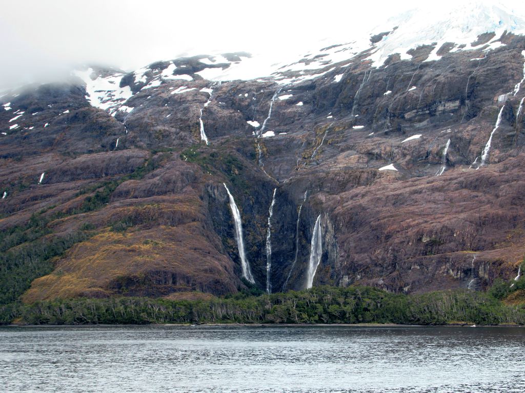
The Beagle's Waters
The Beagle Channel cuts through the park's heart, separating the main island of Tierra del Fuego from the islands of Hoste and Gordon. This is the waterway that gave the HMS Beagle its name - the ship that carried Darwin on his famous voyage, passing through these exact waters in 1833. The young naturalist noted the glaciers, the harsh climate, the 'strange' animals of the Southern Ocean.
Between Gordon Island and the main island lies Glacier Alley - a stretch where seven glaciers descend to the sea in close succession. Their names read like a roll call of European nations: Holland, Italy, Germany, France, Spain. Each one tongues into the channel, blue ice walls rising from black water, the whole tableau framed by peaks permanently capped in snow.
Life at the Edge
The subantarctic climate supports a strange and hardy ecosystem. Forty-nine bird species have been recorded, including condors riding the thermals along the mountain faces and cormorants diving in the frigid waters. Andean foxes and the Argentine gray fox prowl the shores, though you're more likely to see their tracks than the animals themselves.
The waters hold the real abundance. White-bellied dolphins and Peale's dolphins ride the bow waves of passing ships. Sea lions haul out on rocky promontories. Leopard seals - visitors from Antarctica - sometimes appear on floating ice. Southern elephant seals, massive and ungainly on land, transform into torpedoes beneath the surface.
The flora reflects the latitude: subantarctic beech forests on the lower slopes giving way to scrub, then rock, then permanent ice. The wind never stops - it shapes the trees into flags pointing northeast, permanent records of the prevailing westerlies.
Getting There, If You Can
Alberto de Agostini is Chile's least-visited national park because it's nearly impossible to reach. No roads penetrate its boundaries. The only access is by ship from Punta Arenas or Ushuaia - expedition cruises that thread the channels and drop anchor in sheltered fjords, launching Zodiacs to approach the glacier faces.
Supply ships occasionally take passengers, but schedules are irregular and comfort is minimal. Most visitors arrive aboard cruise vessels bound for Antarctica, the park serving as a dramatic prelude to the white continent. The journey from Punta Arenas takes roughly four hours by sea - four hours of narrowing channels, rising mountains, and the growing sense that you've left the ordinary world behind.
There is nothing to buy here, nothing to eat except what your ship provides. The park has no facilities, no ranger stations in the interior, no marked trails. It exists in something close to its primordial state, a reminder of what wilderness meant before we put roads through everything.
A Priest's Legacy
The park takes its name from Alberto Maria De Agostini (1883-1960), an Italian Salesian priest who came to Patagonia as a missionary and became one of its greatest explorers. He made the first ascent of several peaks in the Cordillera Darwin, mapped vast stretches of previously uncharted territory, and produced thousands of photographs documenting landscapes that no European had ever recorded.
De Agostini arrived in Punta Arenas in 1910 and spent the next forty years exploring the region, often in conditions that would defeat modern expeditions. His photographs, now preserved in Italian archives, show a world of glaciers and peaks largely unchanged from what visitors see today. The park was established in 1965, five years after his death - a memorial to a man who loved this landscape before almost anyone else knew it existed.
From the Air
Located at 54.75S, 70.44W. Best viewed from 8,000-12,000 feet to appreciate the scale of the Cordillera Darwin and the fjord system. The mountains rise steeply from sea level to over 2,400 meters in just a few kilometers. Look for the distinctive blue-white faces of tidewater glaciers meeting dark fjord waters - Glacier Alley between Gordon Island and the main island is particularly dramatic with seven glaciers visible in succession. The Beagle Channel runs roughly east-west through the park. Mount Darwin's summit is often obscured by cloud. Nearest airports: Presidente Ibanez (PUQ) in Punta Arenas, Chile (148km northeast) or Ushuaia (SAWH) in Argentina (80km east). Expect heavy cloud cover, strong westerly winds, and rapidly changing conditions. Summer (Dec-Feb) offers best visibility but weather remains unpredictable.