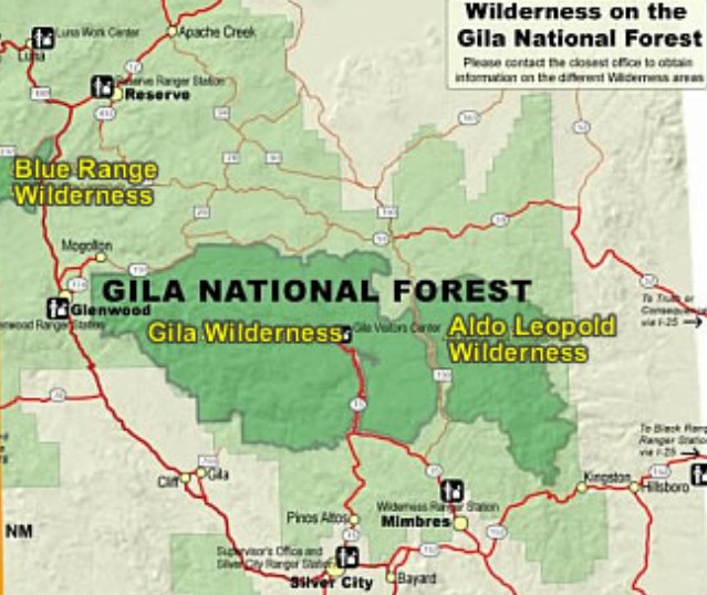
Aldo Leopold Wilderness
In 2011, fewer people walked through the Aldo Leopold Wilderness than had traversed this same terrain a century earlier. This statistic captures something essential about these 316 square miles of New Mexico's Black Range: this is land that has successfully resisted human intrusion, a place where solitude is not a marketing slogan but an inescapable reality. Named for the pioneering conservationist who convinced the Forest Service to protect wild places, the Aldo Leopold Wilderness stands as both monument and living experiment in what happens when humans step back and let nature take the lead.
A Wilderness Born Twice
The land that became the Aldo Leopold Wilderness has been protected territory since 1924, when it formed the southern portion of the Gila Wilderness, the world's first officially designated wilderness area. That protection came largely through the advocacy of Aldo Leopold himself, a young Forest Service employee who had the radical notion that some land should remain forever beyond roads and development. When the original Gila was later reduced in size, this section became the Black Range Primitive Area before Congress granted it full wilderness status in 1980, naming it after the man whose ideas had protected it decades earlier. Today it shares the Gila National Forest with its parent wilderness and the Blue Range Wilderness, forming one of the largest protected wildland complexes in the American Southwest.
Massacre Canyon's Memory
The peaceful wilderness hides a violent past. On September 18, 1879, Apache war chief Victorio and his warriors ambushed approximately 100 Buffalo Soldiers of the 9th Cavalry and their Navajo scouts near Las Animas Creek on the wilderness's eastern edge. The soldiers, African-American troops who had earned their name from the Apache themselves, lost about ten men before managing to withdraw under cover of darkness, abandoning much of their camp equipment to be captured. The canyon where blood soaked into Black Range soil is still called Massacre Canyon, and nearby Victorio Park marks where the Apache leader demonstrated why he was considered one of the most capable guerrilla commanders of the Apache Wars.
Where Life Zones Stack
The Aldo Leopold Wilderness stretches along the Black Range crest like a rumpled blanket tossed north to south, rising to 10,165 feet at McKnight Mountain. This dramatic elevation change, from about 6,500 feet at the lowest points to over 10,000 feet at the peaks, creates stacked ecosystems visible in a single day's hike. Desert vegetation and pinyon-juniper woodland give way to ponderosa pine forests, which surrender to spruce-fir and quaking aspen at the heights. Cottonwood forests line the stream valleys that cut east-west through the range, thousand-foot-deep gashes in the mountain's flanks. Mexican wolves, brought back from the edge of extinction, now hunt these slopes again. The Gila trout, once nearly gone, flickers in Diamond Creek and Black Canyon. The Mimbres River is born here, beginning its journey to vanish in the desert below.
Fire's Constant Reshaping
The 2013 Silver Fire transformed more than 138,000 acres of the wilderness, particularly devastating the higher elevations. But fire has always been part of this landscape's rhythm. Brushy areas, grasslands, and recently burned forests create a patchwork across the wilderness, each representing a different chapter in an ongoing story of destruction and renewal. The fire-scarred slopes host pioneer species, while adjacent old-growth stands show what decades of recovery look like. For visitors willing to accept the wilderness on its own terms, these burn scars become windows into ecological processes usually hidden by the groomed landscapes of managed forests.
The Price of Solitude
More than 200 miles of trails crisscross the Aldo Leopold Wilderness, including 30 miles of the Continental Divide Trail, yet most paths are faint and little-used. Navigation challenges the unwary, and the scarcity of water stops many potential visitors before they start. Streams and springs run seasonal and unreliable here, turning water management into a survival skill rather than an inconvenience. The most accessible entry point leads from Highway 152 at Emory Pass, climbing five miles north to Hillsboro Peak at 10,011 feet. The central ridge trail runs the full length of the mountains, but completing it requires commitment that few possess. Only a gravel road and a narrow corridor of private land separate the Aldo Leopold from the larger Gila Wilderness, making combined trips possible for those with time and determination to spare.
From the Air
Located at 33.11N, 107.85W in southwestern New Mexico's Black Range. The wilderness stretches north-south along the mountain crest, with McKnight Mountain (10,165 ft) as the highest point visible from altitude. The Continental Divide passes through the northern section. Best viewed from 8,000-12,000 feet AGL. Nearest airports include Truth or Consequences Municipal (KTCS) approximately 30nm east and Grant County Airport (KSVC) near Silver City approximately 35nm southwest. Terrain is extremely rugged with steep canyons cutting east-west through the range. Fire scars from the 2013 Silver Fire visible at higher elevations.