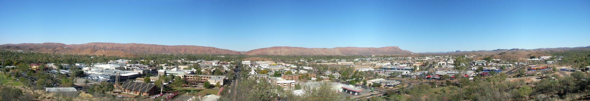
Alice Springs
The Todd River runs through the middle of Alice Springs, except that it almost never runs at all. The riverbed is dry sand most of the year, and the town holds an annual regatta where competitors race bottomless boats by running across the sand carrying them. It is the kind of place that treats absurdity as civic pride. Fifteen hundred kilometres from Darwin to the north and Adelaide to the south, Alice Springs -- Mparntwe in the Arrernte language -- is the largest town in Australia's outback, a settlement of 25,000 people surrounded by country the Arrernte have called home for more than 50,000 years. It began as a telegraph station, grew into a wartime staging post, and became the unlikely hub of Australia's Red Centre tourism boom.
Mparntwe Before Alice
The Arrernte people -- Western, Eastern, and Central groups -- have lived in and around this country since long before the last ice age. Their traditional stories describe the landscape as shaped by ancestral figures: caterpillars, wild dogs, travelling boys, sisters, and euros. The sites that hold these stories are threaded through modern Alice Springs -- Anthwerrke at Emily Gap, Ntaripe at Heavitree Gap, Atnelkentyarliweke where Anzac Hill now stands. The Arrernte language was never written until German missionaries transcribed it using their own phonetic conventions, which is why spellings like Arrernte, Aranda, and Arunta all refer to the same people. Every gorge and waterhole in the MacDonnell Ranges carries both an Arrernte name and a European one, and most locals know the places by both.
A Telegraph Station Named for Someone's Wife
In 1862, John McDouall Stuart led an expedition through Central Australia. A decade later, the Overland Telegraph Line traced his route, and the relay station built beside a waterhole in the MacDonnell Ranges was named Alice Springs -- after Alice Todd, wife of Charles Todd, the telegraph project's chief. The town that grew nearby was called Stuart until the 1930s. Settlement remained sparse until alluvial gold was discovered at Arltunga, 100 kilometres to the east, in 1887. The original transport in the outback was camel trains, driven by immigrants from Pathan tribes in British India who were inaccurately called Afghan cameleers. Camels are still farmed in Central Australia today, and Australia exports purebred camels to the Middle East -- a fact that delights every visitor who learns it.
War, Secrets, and the Cold War Outpost
During the Pacific War, Alice Springs became a critical staging post for Australia's northern defense after coastal shipping to Darwin was deemed too dangerous. The airport was built as a military necessity, and American servicemen brought a lasting cultural influence. After the war, the remoteness that once made Alice Springs irrelevant made it strategically valuable. Seismic monitoring vaults were dug into mounds near town to detect nuclear tests in the Soviet Union. In 1970, the Joint Defence Space Research Facility -- known locally as Pine Gap -- began operations 18 kilometres southwest of town. It is the only location in Australia with permanently prohibited airspace. Residents accept its presence with the dry humor the outback demands: you might glimpse the facility's white radomes on approach to the airport, but you will never get closer than that.
Life at the Red Centre
Alice Springs today is a town that serves multiple roles. For tourists, it is the gateway to Uluru, Kata Tjuta, Kings Canyon, and the MacDonnell Ranges. For the region's remote Aboriginal communities, it is the nearest large town with a hospital, supermarkets, and government services. The tension between these worlds is visible. Socioeconomic challenges stemming from Australia's colonial history persist, and the town grapples with them openly. But Alice Springs is also a place of unexpected richness -- hot air balloon rides at dawn over the Red Centre, camel treks through the Ilparpa Valley, gem fossicking in garnet fields to the north, a desert golf course, and sunsets that locals insist you must see at least once. The Ghan railway links the town to Adelaide and Darwin, and the Stuart Highway runs through Heavitree Gap, a narrow corridor through the MacDonnell Ranges where the highway, railway, and dry Todd River all thread through side by side.
The Town That Distance Made
Everything about Alice Springs is shaped by its isolation. Hotel ratings account for the difficulty of transporting building materials. Rental car contracts prohibit driving on unsealed roads. Fruit and vegetables cost more than in coastal cities because everything arrives by truck along the Stuart Highway. The nearest city of any size is a 17-hour drive in either direction. And yet this remoteness is precisely the point. The outback light at sunrise is so clear it seems to sharpen edges. The silence outside town at night is total. The Arrernte country that surrounds Alice Springs -- the gorges, the ranges, the waterholes that have sustained people for millennia -- offers a landscape so old and so vast that the small town at its center feels less like a destination and more like a camp at the edge of deep time.
From the Air
Located at 23.70S, 133.87E. Alice Springs Airport (YBAS) sits southwest of the town at 1,789 feet AMSL, with approaches typically from the north or south along the Stuart Highway corridor. Heavitree Gap, the narrow passage through the MacDonnell Ranges, is a prominent visual landmark on approach from the south. Pine Gap restricted airspace lies 18 km to the southwest -- avoid overflying. The Red Centre's typically clear skies offer excellent visibility. Key visual landmarks include the MacDonnell Ranges (east-west ridge), the dry Todd River channel through town, and Anzac Hill overlooking the CBD.