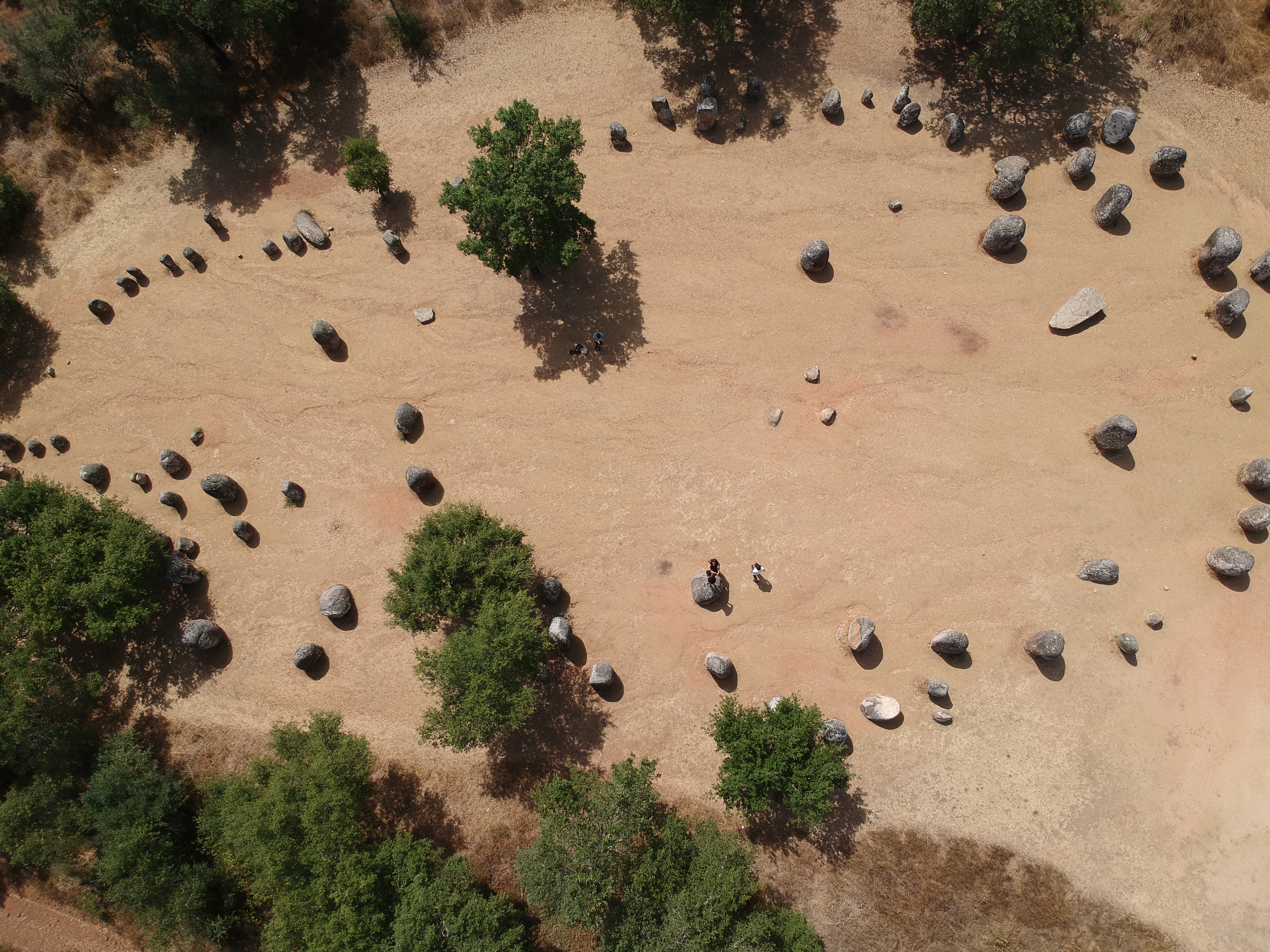
Almendres Cromlech
Long before anyone quarried the bluestones of Stonehenge, people in the Alentejo were dragging boulders into position and aligning them with the sky. The Almendres Cromlech, a sprawling megalithic complex near Evora in southern Portugal, dates its earliest construction phase to around 6000 BC -- the Early Neolithic, when farming was still a novelty in Western Europe. Over the next two millennia, the monument grew through at least three distinct building phases, accumulating nearly a hundred standing stones arranged in elliptical patterns across a gentle hillside studded with cork oaks. It is the largest existing group of structured menhirs on the Iberian Peninsula, and one of the largest in Europe.
Three Millennia of Construction
The cromlech was not built in a single campaign. Excavation has revealed at least three construction phases: Almendres I around 6000 BC, Almendres II around 5000 BC, and Almendres III around 4000 BC, spanning the Early, Middle, and Late Neolithic. The relative chronology extends further, into the Chalcolithic, or Copper Age, making the site's evolution extraordinarily complex. Some stones are large -- solitary boulders standing 2.5 to 3.5 meters tall with rounded or elliptical profiles. Most are smaller and clustered into groups. The cromlech occupies an area roughly 70 by 40 meters, oriented along a northwest-to-southeast axis. Many of the columns show deep erosion on their exposed surfaces, but carved decoration remains visible: lines and radial patterns, with at least two designs on each stone.
Reading the Sky in Stone
The complex sits at a latitude of approximately 38.55 degrees north -- a position that corresponds to the maximum lunar elongation for around 1500 BC. Stonehenge occupies a comparable astronomical latitude, 51.18 degrees, for 2000 BC. Whether coincidence or intention, the alignment suggests the monument may have functioned as a primitive astronomical observatory. Monolith number 8, with its flat-cut top and several small dimples, may have been used for precise observations, particularly of the spring equinox, by placing small marker stones in the depressions. An isolated menhir stands about 1,400 meters to the northeast of the main complex, approximately 4.5 meters tall. Draw a line from the cromlech to this solitary stone, and it points roughly toward the sunrise on the winter solstice.
Carved Figures and Lost Ceremonies
About a dozen monoliths bear carved drawings. Four show only small circular holes -- cupmarks whose purpose remains debated. Menhir 48 is the most striking: it carries a schematized anthropomorphic figure surrounded by concentric circles and associated with what appears to be a crozier, a hooked staff. Whether this represents a deity, a leader, or a purely abstract symbol, no one can say with certainty. The monument is generally believed to have served a religious or ceremonial purpose, though the specific rituals are lost beyond recovery. What survives is the physical effort: thousands of hours of labor by Neolithic communities who quarried, transported, and erected these stones according to a plan that spanned generations.
Rediscovery in the Cork Oaks
The cromlech was unknown to modern scholarship until 1966, when Henrique Leonor Pina stumbled upon it during geological fieldwork for the Portuguese government. The stones had been standing in the open for eight thousand years, surrounded by cork oaks and the rolling grasslands of the Alentejo, but they had escaped archaeological notice. The site belongs to what researchers call the megalithic universe of Evora -- a concentration of prehistoric monuments that includes the nearby Portela de Mogos cromlech and the Vale Maria do Meio Cromlech. The Almendres Cromlech is the largest of them all, a place where Stone Age astronomy, communal ritual, and monumental architecture converge on a quiet hillside in one of Europe's least-visited corners.
From the Air
Located at 38.56N, 8.06W, approximately 12 km west-southwest of Evora in the Portuguese Alentejo. The stone circle occupies a gentle hillside amid cork oak woodland; individual stones may be difficult to distinguish from altitude, but the cleared oval area is identifiable. Nearest airports: Evora (military, LPEV); Lisbon-Humberto Delgado (LPPT), approximately 120 km northwest. Best viewed at 500-1,500 ft AGL. The nearby Escoural Cave and Anta Grande do Zambujeiro dolmen are within 15 km.