Aloha IslandAir Flight 1712
The sun set over Maui at 5:53 p.m. on October 28, 1989. Twenty-two minutes later, Aloha IslandAir Flight 1712 departed Kahului Airport for the short hop to Molokaʻi -- a flight expected to take twenty-five minutes across a channel the crew had crossed six times already that day. On board were eighteen passengers, including five members of the Molokaʻi High School girls' volleyball team, three boys' volleyball players, their head coach, and the school's athletic director. They were heading home. The wreck was found the next morning at 6:25 a.m., crumpled against a mountainside at 600 feet near Hālawa Valley on the eastern end of Molokaʻi. All twenty people aboard -- both crew members and every passenger -- were dead.
A Routine Evening Turns Fatal
Flight 1712 had originated at Hana Airport on Maui's remote eastern coast, stopped at Kahului, and was scheduled to continue to Molokaʻi Airport and then Honolulu. The aircraft was a de Havilland Canada DHC-6 Twin Otter 300, a rugged commuter workhorse powered by twin Pratt & Whitney turboprops. Built in 1973, it had logged 19,875 flight hours across 30,139 takeoff-and-landing cycles. Captain Pollard and First Officer Philip Edwin Helfrich, age 27, had already flown six uneventful inter-island legs that day on the same plane. The seventh would be different. By the time they lifted off from Kahului, they were flying into darkness over mountainous terrain, operating under visual flight rules -- meaning the pilots relied on seeing the ground rather than on instruments to navigate.
Into the Mountains
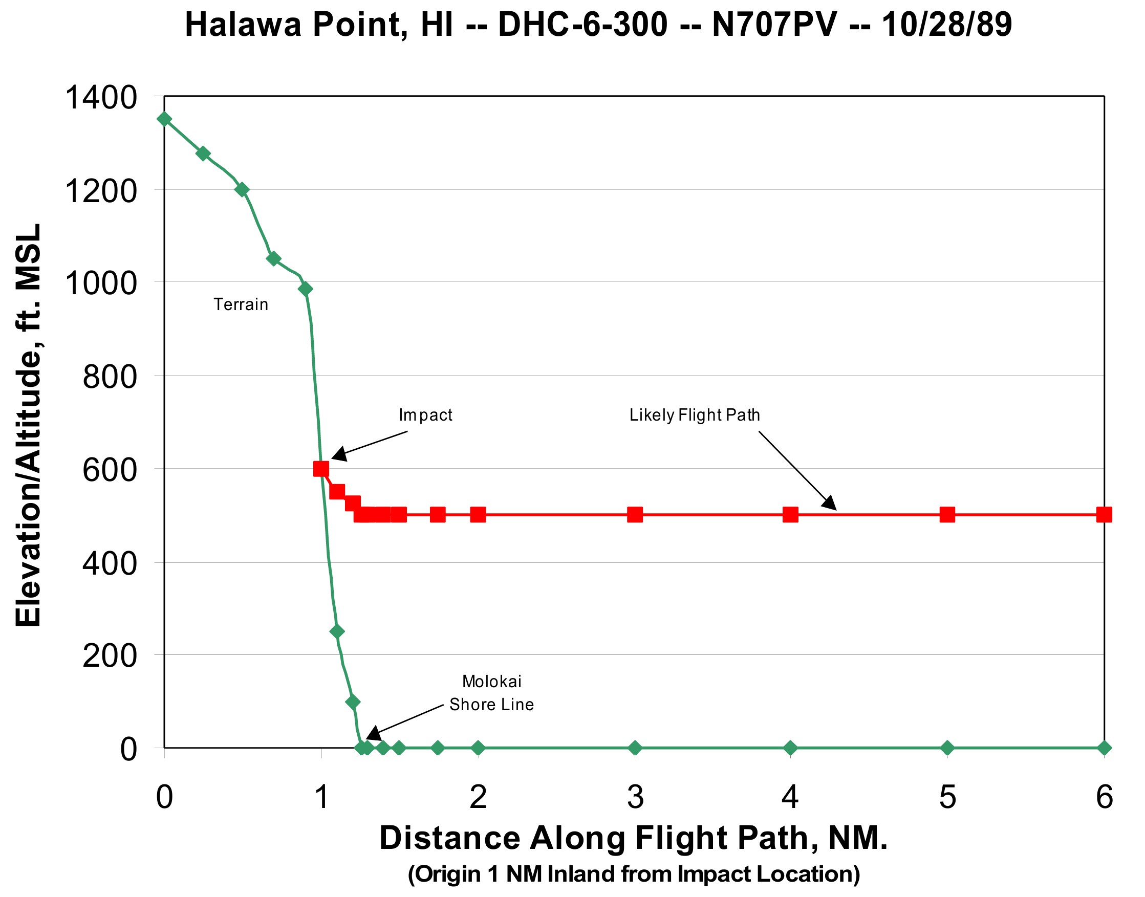
The channel between Maui and Molokaʻi is narrow, but the eastern end of Molokaʻi rises sharply from the sea. Hālawa Valley is flanked by cliffs and ridges that climb steeply from the coast, terrain that becomes invisible on a dark night with poor visibility. The NTSB investigation determined that Captain Pollard continued flying under visual flight rules despite encountering instrument meteorological conditions -- clouds and reduced visibility that hid the rising terrain ahead. The Twin Otter struck the mountainside at an elevation of roughly 600 feet, on a heading of 260 degrees. There was no distress call. The aircraft had no terrain awareness warning system, and the decision to press on by visual reference into conditions that demanded instruments proved fatal.
An Island in Mourning
Molokaʻi is one of Hawaiʻi's smallest and most close-knit communities. The loss of twenty people -- including eight student athletes and school staff -- tore through the island. The crash was the deadliest inter-island aviation disaster in Hawaiian history. Five girls' volleyball players, three boys' players, their head coach, and the athletic director were among the dead, along with four other Hawaiʻi residents and passengers from Pennsylvania and Texas. Seven members of the girls' volleyball team had taken an earlier flight and survived. With the blessing of the victims' families, those surviving players went on to compete at the state volleyball tournament, carrying the weight of grief and the memory of teammates who would never play again.
What Remains
The NTSB attributed the crash to pilot error -- specifically, the captain's decision to continue VFR flight into conditions that required instrument procedures. Captain Pollard had risen quickly through the ranks at Aloha IslandAir, upgrading from first officer to captain just fifteen months before the accident. He had one prior incident, a ground loop in a Piper Cherokee in Juneau, Alaska, in 1986, caused by malfunctioning brakes. The families of some victims used their settlement funds to establish a scholarship at Molokaʻi High School, turning loss into a legacy of education. Every October, the island remembers. The crash site near Hālawa Valley has become a place of quiet remembrance on an island where community bonds run deep and twenty missing faces are still felt decades later.
From the Air
The crash site is located at approximately 21.17°N, 156.74°W, on the eastern end of Molokaʻi near Hālawa Valley, at roughly 600 feet elevation. The terrain rises steeply from the coast here, with ridgelines exceeding 2,000 feet. Molokaʻi Airport (PHMK) lies on the island's central plain to the west. Kahului Airport (PHOG) on Maui, the departure point, is across the Pailolo Channel to the southeast. The route crosses open water before encountering Molokaʻi's rugged eastern mountains -- terrain that demands instrument awareness in low-visibility conditions.