Altavista (Zacatecas)
On the summer solstice, sunlight passing over two circle-cross petroglyphs on the Chapin plateau aligns precisely with a summit called Picacho Mountain, seven kilometers to the southwest. The alignment is not accidental. The builders of Altavista designed their ceremonial center between 450 and 470 CE using astronomical calculations that echo those found at Teotihuacan, hundreds of kilometers to the south. This was the northern frontier of Mesoamerica -- the farthest point at which the great civilizations of central Mexico extended their cultural reach -- and its architects intended it to be as precisely ordered as any temple complex in the Valley of Anahuac.
Precious Stone on the Frontier
The site sits within the Sierra de Chalchihuites, named from the Nahuatl word chalchihuitl, meaning 'precious stone.' The Chalchihuites-Chichimec culture established itself here and flourished during the Mesoamerican classical period, roughly 400 to 650 CE. These were not simple villagers at the edge of civilization. They had a hieroglyphic writing system, urbanization techniques, a numbering system, and sophisticated astronomical knowledge. Their ceremonial center functioned as a control point on the turquoise trade route that originated in the Oasisamerican mines of what is now New Mexico and ran southward into the heart of Mesoamerica. Turquoise was as prized as jade in the ancient Mexican world, and Altavista sat astride the pipeline.
A Culture of Transition
Archaeologist Manuel Gamio classified the Chalchihuites as a 'culture of transition' -- a bridge between the sedentary Mesoamerican civilizations to the south and the nomadic Chichimec hunter-gatherers who inhabited the arid northern plateau. The culture spread along the eastern flanks of the Sierra Madre Occidental from western Zacatecas to Durango between 100 and 1250 CE. Its Suchil branch developed the Altavista ceremonial center, while the Guadiana branch extended north to La Ferreria near the city of Durango and El Zape beyond. Around 800 CE, a devastating drought ruined farming in the Mexican semi-desert, and population at Altavista collapsed. But the site was not abandoned permanently -- evidence suggests intermittent occupation continued until roughly 1400 CE, a span of thirteen centuries.
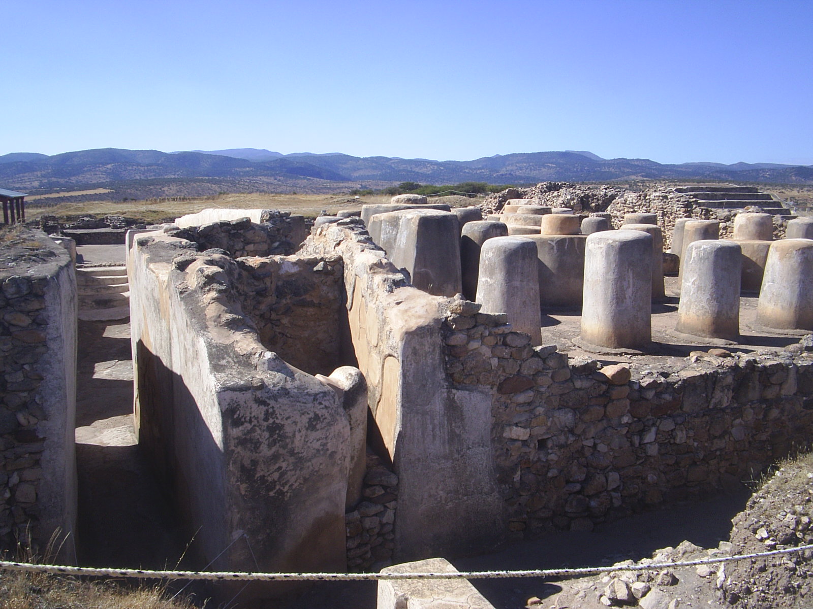
Columns, Labyrinths, and Solstice Lines
In 1908, Manuel Gamio conducted the first scientific excavations in northern Mexico at Altavista, exploring the zone now known as the Columns Hall and its annexed stairway. He also investigated caverns in the surrounding hills, which he interpreted as defensive refuges. The site then lay undisturbed for over six decades until J. Charles Kelley began extensive excavations in 1971. Kelley's thirty years of research revealed the full sophistication of the site: the ceremonial center was not randomly placed but positioned according to precise astronomical directions from the Chapin plateau. The circle-cross petroglyphs found there resemble those at Teotihuacan, and the summer solstice alignment connecting them to Picacho Mountain relates to the Labyrinth structure within the archaeological site itself.
Northern Mesoamerica's Last Outpost
Altavista represents the maximum northern expansion of Mesoamerican civilization. Beyond this point, the cultural landscape shifted to Oasisamerican traditions -- the Mogollon, Ancestral Puebloan, and Hohokam cultures of what is now the American Southwest. The question of whether Mesoamerican cultures migrated northward to seed these communities, or whether influence flowed in both directions, remains one of the most debated topics in North American archaeology. What Altavista demonstrates is that the boundary was not a wall but a membrane. Turquoise moved south; agricultural techniques and astronomical knowledge moved north. Architectural forms echoed across hundreds of kilometers. The ruins at Altavista, weathered but still legible, mark the spot where two hemispheres of ancient American civilization touched.
From the Air
Altavista is located at 23.48N, 103.95W near the municipality of Chalchihuites in northwestern Zacatecas. The site is in the Sierra de Chalchihuites foothills on the eastern flanks of the Sierra Madre Occidental. The nearest airport is General Guadalupe Victoria International (ICAO: MMDO) in Durango, approximately 90 km to the northwest. From altitude, the archaeological zone is difficult to distinguish from surrounding terrain, but the Sierra de Chalchihuites ridgeline is identifiable. Best viewed at 2,000-4,000 ft AGL in clear conditions.