Amalfi Coast
The Amalfi Coast defies geology. Villages that should slide into the sea instead cascade down cliffs, their buildings stacked so steeply that one house's roof becomes another's foundation. Lemon trees grow on terraces carved from near-vertical rock faces, supported by walls that represent centuries of labor. The road - there is essentially just one - threads along the cliffside through tunnels, around hairpins, past viewpoints that stop traffic (sometimes literally) with their beauty. UNESCO recognized this 50-kilometer stretch of Campanian coastline for its cultural landscape: the fusion of Mediterranean terrain and human settlement into something that seems both impossible and inevitable. From Sorrento in the west to Salerno in the east, the Costiera Amalfitana presents Italy at its most scenic and most challenging to navigate.
The Famous Three
Three towns draw most visitors to the coast: Positano, Amalfi, and Ravello, each distinct in character. Positano tumbles down to the beach in a cascade of pink and white buildings, its car-free center accessible only by foot - meaning hundreds of steps climbing from sea level to the hotels and restaurants above. Amalfi proper occupies a rare patch of flat ground where a valley meets the sea, its cathedral rising from a grand staircase in the central piazza. Ravello sits high above the coast, its gardens and villas - particularly Villa Cimbrone and Villa Rufolo - offering views that have inspired composers and writers for centuries. The towns are connected by the SS163 coast road, by ferry services running May through October, and by footpaths that predate any road. Which you prefer depends on whether you want beach access (Positano), historical center (Amalfi), or elevated escape (Ravello).
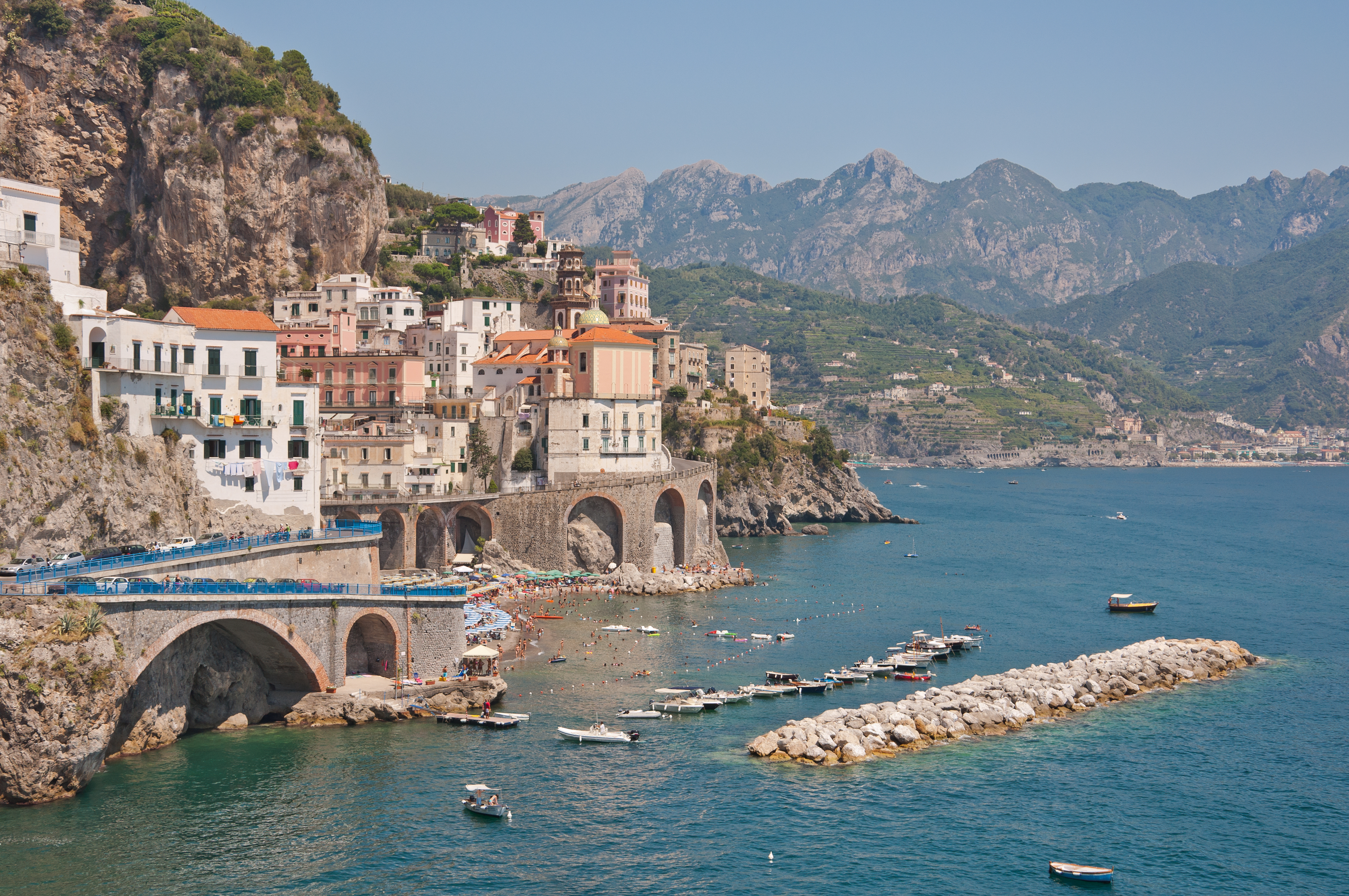
Maritime Republic
Before Venice and Genoa dominated Mediterranean trade, Amalfi was among Italy's most powerful maritime cities. From the 9th through 11th centuries, Amalfi's ships sailed throughout the Mediterranean and beyond, establishing trading colonies and developing the Tavole Amalfitane - the maritime law code that governed Mediterranean shipping for centuries. The town's compass rose became a symbol of navigation itself. The Duomo di Amalfi, with its Arabic-influenced cloister and Byzantine bronze doors, reflects the cosmopolitan wealth this trade generated. The Paper Museum in the Valley of the Mills documents another legacy: Amalfi was Europe's first producer of paper, using water-powered mills that operated until the mid-20th century. Today the maritime glory is memory, but the architecture it funded remains, climbing the hillsides in configurations that no later poverty could have built.
Lemons and Limoncello
The Amalfi Coast's signature product grows on terraces that seem to defy gravity. The sfusato amalfitano lemon - elongated, fragrant, with thick skin and sweet flesh - thrives in the microclimate created by mountains and sea. The terraces that support the groves required generations to construct, dry stone walls stacked up slopes too steep for machinery, maintained by hand even today. These lemons flavor everything: granita, pasta, fish, and especially limoncello, the sweet lemon liqueur served ice-cold after meals throughout southern Italy. The drink originated here, homemade before it became commercial, its recipe essentially unchanged: lemon zest steeped in pure alcohol, mixed with sugar syrup, consumed from frozen glasses. Visiting in May or June means seeing the groves heavy with fruit, the scent of lemon blossoms mingling with Mediterranean sea air.
The Coastal Road
The SS163, known as the Strada Statale Amalfitana, might be Italy's most famous and most challenging drive. Cut into the cliffside in the mid-19th century, the road features over a thousand curves, dozens of tunnels, and an average width that makes passing buses a exercise in mutual trust and mirror-folding. Traffic restrictions during peak season ban tourist buses at certain hours; license plate systems can prohibit odd or even numbered cars on alternate days. The alternative is SITA buses, which run the route regularly and whose drivers possess either supernatural skill or complete absence of fear. Better still are the ferries connecting major towns, offering spectacular views without white-knuckle stress. Or simply walk: the Sentiero degli Dei (Path of the Gods) traces the ridgeline high above the coast, connecting villages through landscapes that reward every steep step.
Visiting the Coast
The Amalfi Coast operates on seasonal rhythms. High summer brings maximum crowds, maximum prices, and traffic that can turn the coastal road into a parking lot. The shoulder months of May and October offer reliable weather without the crush - swimming is still possible, ferries still run, but hotels cost less and restaurants have tables. Day trips from Naples or Sorrento are possible but frustrating; spending at least one night on the coast allows experiencing the villages after the tour buses leave. Capri lies just offshore, connected by ferry for easy day trips; Pompeii and Herculaneum make compelling excursions. Those arriving by air typically fly to Naples, from which Sorrento is reached by Circumvesuviana train and the coast by bus or ferry. Bring shoes for climbing steps - thousands of them - and an appetite for seafood, lemons, and views that justify every superlative.
From the Air
Located at 40.63°N, 14.60°E along the southern shore of the Sorrentine Peninsula in Campania, Italy. The coastline appears from altitude as an extremely steep, terraced landscape with villages clustered in small valleys and on cliff faces. The distinctive hairpin curves of the SS163 coast road are visible threading along the cliffs. Positano, Amalfi, and other villages show as dense clusters of buildings descending to small harbors. Ravello sits notably higher than other towns. Naples International Airport (NAP) lies 50km northwest. The island of Capri is visible 5km offshore to the west.