Sacramento's Wild Corridor
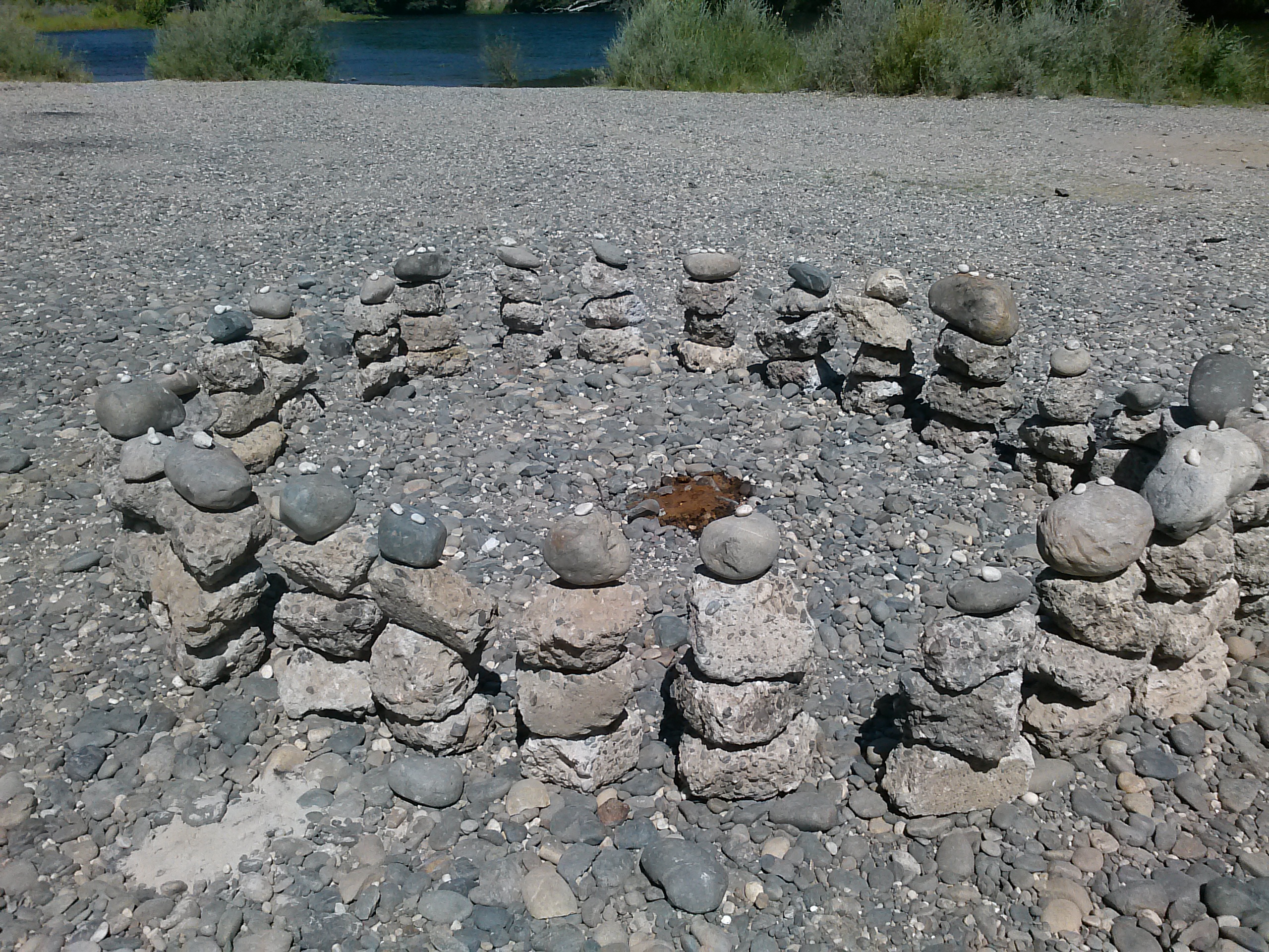
Someone has been stacking rocks along the American River. Not haphazardly, but in deliberate, sculptural formations -- balanced cairns and spiraling columns that appear overnight near the Watt Avenue access point, visible from the road above. Nobody knows who builds them or why. The anonymous "Rock Artist" has become one of the small, unexplained delights of the American River Parkway, a 32-mile recreational corridor that threads through Sacramento County from the confluence of the American and Sacramento Rivers all the way east to Folsom. In a city that sprawls across a flat valley floor, the parkway is the seam where wildness persists -- a ribbon of cottonwood forest, rapids, and quiet ponds running through suburbs, office parks, and strip malls.
Where Two Rivers Meet
The parkway begins at Discovery Park, a 302-acre spread where the American River empties into the Sacramento River just outside downtown. This is the trailhead for the Jedediah Smith Memorial Trail, a paved path that follows the river for the parkway's full 32-mile length through the historic Leidesdorff Ranch to Folsom. The park hosts softball fields, an archery range, boat ramps, and every October becomes the site of the Aftershock Festival and Golden Sky festival, when the confluence of two rivers is drowned out by the confluence of electric guitars. Discovery Park sits on ground that once belonged to William Leidesdorff, an entrepreneur of Afro-Caribbean descent born in St. Croix (then the Danish West Indies) who became one of early San Francisco's most prominent citizens before his death in 1848, just as gold fever was beginning to transform the region.
A Boxing Manager's Legacy
Upstream in Carmichael, Ancil Hoffman Park covers 396 acres of ancient oaks bordered on two sides by the river. The park is named for Ancil Hoffman, a Sacramento County Supervisor who also managed the heavyweight boxer Max Baer -- the man who knocked out Primo Carnera in 1934 to become world champion. Hoffman's dual life as a county official and fight manager seems improbable today, but Sacramento in the mid-twentieth century was a smaller, more improvisational place. Inside the park, reconstructed Maidu homes stand as reminders that people lived along this river for thousands of years before the county began acquiring parkland in the early 1960s. The Effie Yeaw Nature Center introduces visitors to the wildlife that still thrives here: wild turkey picking through the leaf litter, hawks circling above the canopy, deer browsing at the river's edge.
What's in a Name
River Bend Park, a 444-acre stretch near where the American River curves through Rancho Cordova, carries a name that replaced its original one. Until 2008, this was Goethe Park, named after Charles M. Goethe, a Sacramento philanthropist whose legacy darkened considerably when his enthusiastic support for eugenics became more widely known. The county renamed the park, quietly erasing the honor. It is one of Sacramento County's oldest regional parks and was among the three original parcels the county acquired between 1961 and 1964 to form the parkway's backbone. A pedestrian bridge -- the Harold Richey Bicycle Bridge -- connects it to William B. Pond Recreation Area across the river, where a man-made pond stocked with trout and catfish draws anglers, and the surrounding habitat shifts between riverside forest, open fields, and swift rapids.
Life Jackets on Loan
The parkway's relationship with water is intimate and sometimes dangerous. The American River runs cold and fast in places, and the parks along its banks do not pretend otherwise. At several access points, life jacket loaner stations stand stocked with vests in various sizes -- take one, use it, return it when you are done. The system operates entirely on trust, a small civic gesture that says something about the parkway's character. This is a place that invites people in without fencing off the risks. Swimmers wade into rapids that can sweep feet from under the unwary. Kayakers run sections that demand genuine skill. The river does not perform for visitors; it simply continues doing what it has done since long before Sacramento existed, carving its path from the Sierra Nevada through the Central Valley to the sea.
The Thread That Holds
The American River Parkway Foundation, headquartered at the William B. Pond Recreation Area in Carmichael, works to preserve and maintain the corridor through volunteer programs and environmental education. Their modest headquarters -- a single-story, 1,800-square-foot building completed in 2004 -- belies the scale of what they steward. Thirty-two miles of urban wildness requires constant attention: levees must be maintained to prevent flooding, invasive species managed, trails repaired, and the tension between recreational use and ecological preservation negotiated year after year. From the air, the parkway reads as a dark green line against Sacramento's beige grid -- proof that a city built on a floodplain can choose to leave the flood-prone land to the river, and in doing so, give itself something irreplaceable.
From the Air
Located at 38.62N, 121.30W, the American River Parkway runs 32 miles through Sacramento County from the American-Sacramento River confluence near downtown Sacramento east to Folsom Lake. From the air, the parkway is clearly visible as a forested corridor following the American River through developed suburbs. Sacramento Executive Airport (KSAC) lies approximately 5nm south of the western end; Sacramento International (KSMF) is 12nm northwest. Mather Airport (KMHR) is near the eastern sections. Best viewed at 2,000-4,000 feet AGL, where the contrast between the green parkway and the surrounding urban grid is most striking.