Anegada
The Spanish named it tierra anegada - flooded land - because it barely exists. Anegada's highest point rises just 28 feet above sea level, making it invisible to approaching sailors until they're already in trouble. While every other inhabited island in the British Virgin Islands was thrust up by volcanic forces, Anegada was built by coral and limestone, a flat disc of reef-made land that looks, from the air, like someone dropped a sand dollar into the Caribbean Sea. That invisibility has defined everything about the island: its shipwrecks, its isolation, and its unlikely role as a sanctuary for species that have vanished everywhere else.
The Reef That Eats Ships
Horseshoe Reef extends 18 miles off Anegada's southern shore, making it one of the largest barrier coral reefs in the Caribbean. For centuries, this reef has been eating ships. Hundreds of wrecks lie scattered across its coral - HMS Astraea in 1808, the Donna Paula in 1819, the MS Rocus in 1929, and scores of unnamed vessels whose crews never saw the island until the grinding sound told them it was too late.
The reef remains so dangerous that modern charter companies often forbid their clients from sailing to Anegada at all. In a region where bareboat sailors roam freely among dozens of islands, Anegada sits behind a coral barricade that demands local knowledge and careful navigation. The BVI government has made anchoring on Horseshoe Reef illegal to protect the coral, but the protection works both ways - the reef shields the island's north side from storm surge and breaking waves, even during Category 5 hurricanes.
Flamingos, Iguanas, and a Zoo from Texas
In the 1830s, thousands of Caribbean flamingos waded through the salt ponds that cover Anegada's western end. Hunters killed them for food and feathers throughout the nineteenth and early twentieth centuries until the last birds disappeared around 1950. The flamingos have been reintroduced, and as of 2016 the flock numbers approximately 200 - enough to turn visitors' heads but still fragile enough that officials limit access to the nesting areas.
The salt ponds were designated a Ramsar Site in 1999, and BirdLife International has recognized the western ponds and southeastern mangroves as an Important Bird Area. But Anegada's most distinctive resident is the Anegada rock iguana, Cyclura pinguis, a critically endangered species found nowhere else. The Fort Worth Zoo maintains a "Headstart" facility in the Settlement where newly hatched iguanas are raised until they're large enough to survive the feral cats that are their only predator on the island. Over 200 iguanas have been released back into the wild through this program.
Conch Shells and the Settlement
Almost all of Anegada's 450 residents live in a single village called, with characteristic directness, the Settlement. Visitors arriving by boat or by charter flight into tiny Auguste George Airport are greeted by an unmistakable landmark: mountains of empty conch shells piled along the shore, the accumulated evidence of generations of fishing. The reef adjacent to the Settlement was once one of the Caribbean's most fertile conch grounds, but overfishing has wiped out the local population. The shells remain as monuments to abundance that didn't last.
Commercial fishing still drives the economy alongside tourism. Local fishermen supply most of the fresh fish and lobster consumed across the entire British Virgin Islands. The island's south shore flats harbor large populations of bonefish, drawing fly fishermen from around the world. On a typical day during tourist season, Anegada hosts 200 to 300 visitors - outnumbered by its permanent residents but not by much.
Riding Out the Storm
Anegadians have a traditional hurricane survival technique: tie your dory to a mangrove trunk with rope, cover it with a tarp, and wait. On a 28-foot-high island with nowhere to shelter from storm surge, preparation is less about fortification than acceptance.
Hurricane Earl tested that resolve in August 2010, passing 15 miles north as a Category 4 storm. Twenty-four hours before it hit, forecasters expected it to pass well to the north. By the time the threat became clear, all air and ferry service had been suspended - the island's 450 residents were on their own. Major flooding struck the south side, but Horseshoe Reef shielded the north from the worst. No serious injuries were reported. Seven years later, Hurricane Irma's northern eyewall passed directly over Anegada as a Category 5. Most residents stayed. Again, the reef broke the north-side waves. Again, no one was seriously hurt. The island endures because the coral that makes it invisible also makes it resilient.
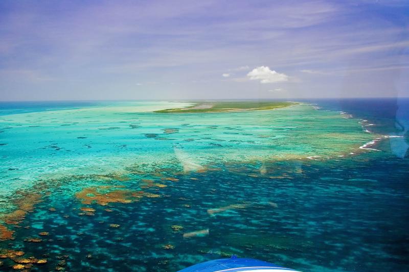
From the Air
Located at 18.73N, 64.33W, approximately 15 miles north of Virgin Gorda. Anegada is strikingly different from every other BVI island when viewed from altitude - completely flat and low (max 28 feet elevation) while surrounding islands are mountainous and volcanic. The island appears as a thin white line of beach surrounding green-brown scrubland with extensive salt ponds on the west end. Horseshoe Reef is visible as a turquoise arc extending 18 miles to the southeast. Auguste George Airport (ICAO: TUPA, IATA: NGD) has a small runway. The Settlement is on the south-central coast. Best viewed from 2,000-4,000 feet to see the reef system and contrast with the volcanic islands to the south.