Angel Mounds
For three and a half centuries, a walled city of a thousand people stood on the banks of the Ohio River in what is now southwestern Indiana. Its residents built thirteen earthen mounds, farmed the rich floodplain for corn, beans, and squash, crafted distinctive pottery, and traded with communities along the Ohio and Mississippi rivers. Then, sometime around AD 1450, they left. No Europeans ever saw this city alive. When Mathias Angel began buying the farmland in 1852, the mounds were just strange hills in a farmer's field. It would take another eighty years before archaeologists understood what lay beneath them: the political, cultural, and economic capital of a chiefdom that once stretched from the Wabash River to the Green River in Kentucky.
Built by Basket, Brick by Earth
The Mississippian culture that produced Angel Mounds developed around AD 900 along the Mississippi River valley and its tributaries, eventually extending from Oklahoma to North Carolina. At Angel, construction began sometime after AD 1000. Laborers carried dirt in baskets from a waterway along the town's south side to raise the mounds, working with varied soils to create stable masses. The Central Mound -- Mound A -- is the largest, containing three levels with a smaller conical mound in its southeast corner. Based on what early European explorers observed at other active Mississippian villages, this mound likely served as the residence of the hereditary chief. The community eventually covered a substantial area and included thirteen mounds near the river, hundreds of home sites, and a defensive palisade built of wattle and daub -- sticks woven together and plastered with mud and grass -- punctuated with bastions spaced to let defenders protect the walls with arrows and lances.
Life Along the Ohio
The site's location was no accident. Annual spring floods replenished nutrients in the soil, enabling surplus crop production that supported artisan specialties like pottery. A channel and slough surrounded the town on three sides, creating a quiet backwater ideal for canoe transit, fishing, and fresh water. The Angel chiefdom functioned as the regional trading center for communities within the Ohio River valley, bounded by the White River and its East Fork to the north, the Wabash River to the west, and the Anderson River to the east. Smaller villages, hamlets, and farmsteads were politically subordinate to the main site. Archaeologists have found bone fishhooks and cord nets for catching catfish and drumfish, spears with projectile points for hunting small game, and tools made of sandstone, slate, shale, and diorite. Of the nearly two million pottery sherds recovered from the site, 4,569 are of the distinctive negative-painted type. In 2006, researchers discovered a pottery workshop -- a production-line operation where masses of prepared, slightly fired clay awaited finishing and firing as bowls, jars, and figures.
The Vanishing
The Mississippian people abandoned Angel Mounds long before any European set foot in the Ohio Valley. Scholars have proposed several explanations: an extended regional drought that reduced corn surpluses, overhunting, deforestation from wood consumption for construction and fires, or a combination that made the concentrated population unsustainable. By around AD 1450, the Angel chiefdom had collapsed. Many inhabitants appear to have relocated downriver to the confluence of the Ohio and Wabash rivers, where a separate cultural group emerged that archaeologists call the Terminal Mississippian Caborn-Welborn phase, lasting from roughly AD 1400 to AD 1700. By AD 1650, the Mississippians had left the Ohio River valley entirely. Over the following centuries, Shawnee, Miami, and other peoples moved through the region, followed by European traders and Anglo-American settlers. None of them knew they were walking over a buried city.
Rescued from the Plow
In May 1931, archaeologist Warren K. Moorehead, Eli Lilly (then becoming president of both Eli Lilly and Company and the Indiana Historical Society), and archaeologist Glenn A. Black visited the Angel site during a tour of Indiana's archaeological resources. Black recognized the potential for a long-term study. In 1938, with the mounds threatened by levee construction and real estate development, the Indiana Historical Society purchased the property using funds provided by Lilly. From 1939 to 1942, a Works Projects Administration crew of more than 250 workers excavated the site under Black's direction, recording and processing 2.3 million archaeological items. One of the most significant finds came in November 1940: a carved fluorite statue of a seated man, unearthed at Mound F. Similar rare fluorite statues have been found at only two other sites, the Obion Mounds in Tennessee and the Ware Mounds in Illinois.
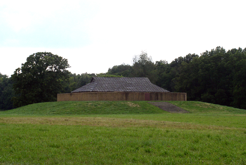
A Landmark Preserved
Designated a National Historic Landmark in 1964, Angel Mounds State Historic Site now encompasses a large expanse of land southeast of Evansville. The property includes an interpretive center opened in 1972, reconstructions of Mississippian structures, and a replica of the 1939 WPA archaeology laboratory. A nature preserve and recreational trails occupy a separate portion of the grounds. Mound F, the only mound fully excavated, was destroyed during the process and subsequently reconstructed to show its original appearance, complete with a temple structure, palisade, and stairs leading to the summit. Between 1958 and 1962, National Science Foundation grants funded the use of a proton magnetometer to trace buried palisade walls invisible from the surface -- one of the first comprehensive tests of the instrument in the Americas. Today, Indiana University continues archaeological fieldwork at the site, and the 2.4 million artifacts recovered are curated at the IU Museum of Archaeology and Anthropology in Bloomington. Each season of digging reveals new elements of a complex society that thrived here half a millennium before Columbus.
From the Air
Located at 37.94N, 87.46W on the north bank of the Ohio River, approximately 7 miles southeast of Evansville, Indiana, in Vanderburgh and Warrick counties. The thirteen mounds are subtle earthen features best visible at low altitude in low-angle light (early morning or late afternoon) when shadows define the contours. The site sits on the river's floodplain with the Ohio River's curve providing a strong visual reference to the south. Nearest airports: Evansville Regional Airport (KEVV) approximately 8 nm to the west-northwest. The terrain is flat river bottomland with scattered woodland. Best viewed at 1,500-2,500 ft AGL. Look for the cleared archaeological site along the river bend, distinct from the surrounding agricultural land and wooded nature preserve.