Angkor
A Chinese diplomat named Zhou Daguan arrived at Angkor in 1296 and wrote down everything he saw. He described the golden towers of the royal palace, the Buddhist monks in yellow robes, the Brahmin officials, the markets teeming with fish and rice, the elaborate procession of the king on his golden palanquin escorted by cavalry and elephants. What Zhou was witnessing, though he could not have known it, was a civilization approaching its end. Within 135 years, Ayutthaya invaders would sack the city, and its population would scatter southward toward what would eventually become Phnom Penh. The jungle would close over the temples. But in 1296, Angkor was still magnificent -- a hydraulic metropolis covering more than 1,000 square kilometers, fed by a water management system that NASA radar imaging would later reveal to be larger than modern Los Angeles.
The King Who Made Himself a God
Angkor's story begins in 802 AD, on a mountain called Mahendraparvata in what are now the Kulen hills. There, a prince named Jayavarman II performed a Hindu consecration ritual and declared himself chakravartin -- universal monarch -- and devaraja, god-king. He had already spent years defeating rival rulers and consolidating a kingdom called Kambuja. The declaration on Mahendraparvata was his announcement that Kambuja owed fealty to no foreign power. He established the city of Hariharalaya, now called Roluos, near the northern end of Tonle Sap lake. His successors expanded outward. Yasovarman I founded Yasodharapura around 889, building the city's central temple atop Phnom Bakheng, a natural hill rising 60 meters above the plain. He also created the East Baray, a reservoir measuring over 7 kilometers long -- the first of Angkor's great engineered lakes.
A Warrior on an Elephant
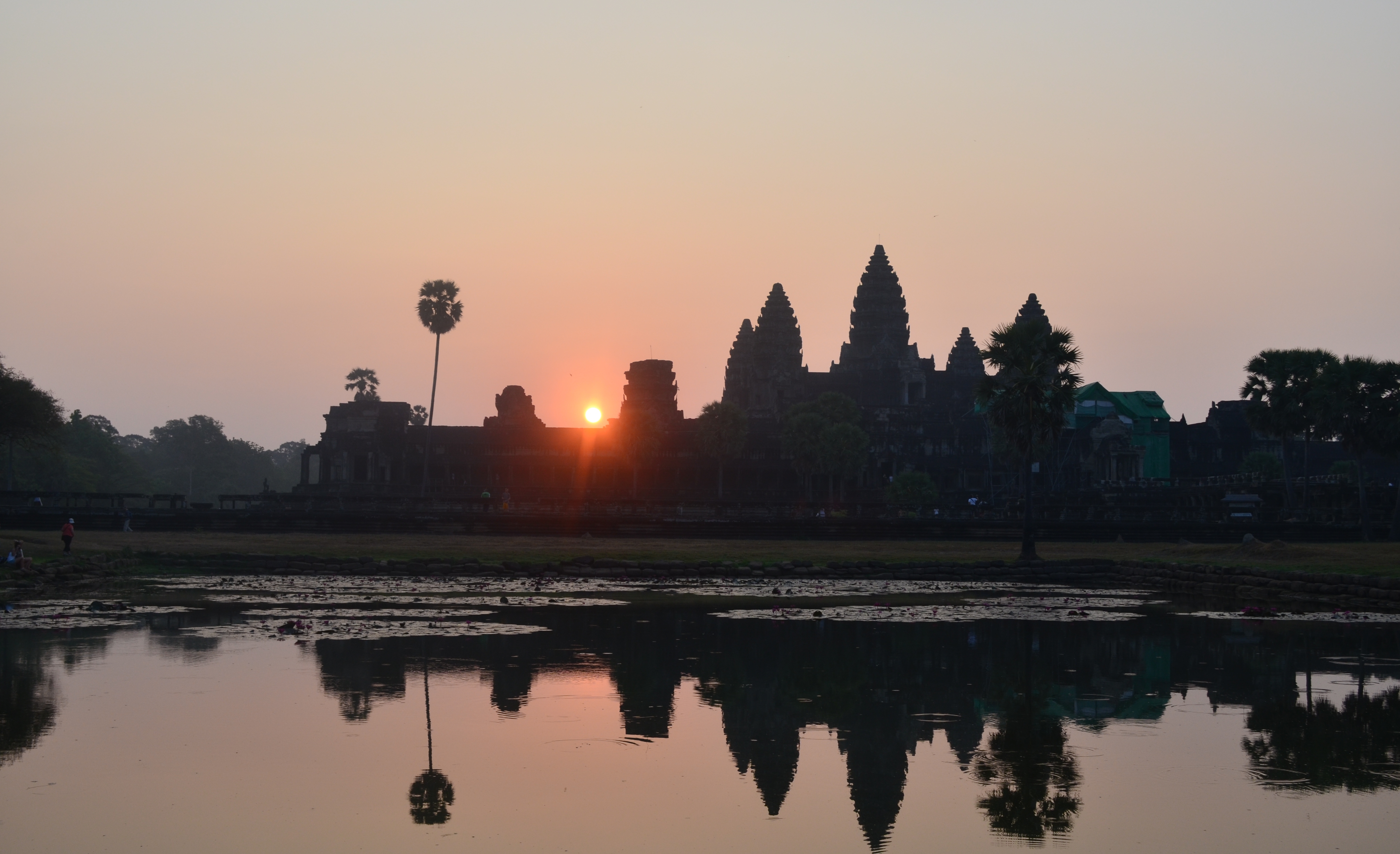
The Angkorian period's most ambitious builder arrived on the throne through violence. According to inscriptions, Suryavarman II leapt onto his rival's war elephant during combat and killed the prince in single combat, like the mythical bird-man Garuda slaying a serpent. After consolidating power through campaigns and diplomacy, he poured the empire's resources into Angkor Wat, breaking with royal tradition by dedicating it to Vishnu rather than Shiva. With walls nearly half a mile on each side, the temple embodied Hindu cosmology in stone. But Suryavarman's death around 1150 unleashed chaos. Rival claimants fought for the throne. In 1177, the Cham -- from what is now southern Vietnam -- launched an audacious naval invasion up the Mekong River and across Tonle Sap, sacking the capital and killing the reigning king.
The Last Great King
From that disaster emerged Jayavarman VII, who rallied the Khmer and drove out the Cham in battles on both lake and land. Assuming the throne in 1181, he became arguably the greatest of all Angkorian rulers -- and the last to build on a monumental scale. Over the ruins of Yasodharapura, he constructed the walled city of Angkor Thom with the Bayon at its center, a temple from which 216 enormous stone faces gaze outward in serene half-smiles. A follower of Mahayana Buddhism rather than Hinduism, Jayavarman VII shifted the empire's spiritual foundations. He built hospitals, rest houses along the roads, and the temple of Ta Prohm, which he dedicated to his mother. The inscriptions describe a kingdom at its peak: 306,372 people served the temples alone, consuming 38,000 tons of rice per year.
Death by Water
The Khmer empire depended on water -- capturing monsoon rains in massive reservoirs, then distributing it through canals to irrigate rice paddies during the dry months. The West Baray alone measured eight kilometers by two. But research by the Greater Angkor Project has revealed that this system was ultimately fragile. Tree-ring data and sediment cores show that a period of strong monsoons gave way to severe droughts in the 14th and 15th centuries. The swings between flooding and drought damaged canal infrastructure faster than it could be repaired. Meanwhile, ongoing wars with the Ayutthaya Kingdom drained resources and manpower. By the time Ayutthaya forces sacked Angkor in 1431, the population had already begun migrating south. Zhou Daguan had noted the devastation of constant warfare even in 1296, reporting that the entire population had been obligated to participate.
What the Jungle Kept
After 1431, nearly all of Angkor was abandoned. Only Angkor Wat survived as an active shrine, maintained by Buddhist monks. The rest vanished under forest canopy, known to local farmers but invisible to the wider world. French explorers arrived in the 1860s and described what they found as if it were a lost civilization, though Cambodians had never truly forgotten it. Today, archaeologists have mapped over a thousand sites across the ancient metropolitan area. The sandstone monuments continue to weather -- two million tourists per year walk and climb the temples, accelerating erosion that centuries of jungle growth had paradoxically slowed. UNESCO and Cambodian authorities now manage visitor flows to protect what remains of a city that, in its prime, dwarfed every contemporary European capital.
From the Air
Located at 13.43°N, 103.83°E in Siem Reap Province, Cambodia. The ancient city covers over 1,000 square kilometers of forested terrain north of Tonle Sap, the largest freshwater lake in Southeast Asia. The rectangular West Baray (8km x 2km) and East Baray are visible from altitude as geometric clearings. Angkor Wat's moat and central towers form the most identifiable landmark. Siem Reap-Angkor International Airport (VDSR/REP) lies 6km south of the main temple complex. The Tonle Sap lake dominates the landscape to the south. Fly over during clear conditions to appreciate the scale of the hydraulic network connecting reservoirs, canals, and temple moats.