Anjajavy Forest: Where Stone Forests Meet Living Ones
The village gave the forest its name, and the forest got it from a tree. Salvadora angustifolia, called jajavy in Malagasy, grows in the mangrove swamps that flank the peninsula, and so the village became Anjajavy - the place of the jajavy tree. The forest that surrounds it covers roughly fifty square kilometers of a peninsula in northwest Madagascar, bounded by Majajamba Bay to the south and Narinda Bay to the north. What makes this particular stretch of dry deciduous forest extraordinary is what lies beneath it: tsingy, the razor-edged limestone karst formations that rise like stone forests within the living one, their inaccessibility and resistance to fire having protected the primary forest above for millennia.
The Stone Labyrinth
Tsingy translates roughly as "where one cannot walk barefoot," and the description is precise. These karstic formations take the shape of limestone towers, spurs, and needles rising as high as 30 meters, their edges honed by millennia of tropical rain dissolving the soft rock along its fracture lines. Within the forest, the tsingy creates a three-dimensional maze of caves, grottos, gorges, and walls that nature has colonized with particular ingenuity - roots threading through crevices, epiphytes clinging to vertical faces, geckos flattening themselves against surfaces that would draw blood from a bare hand. Along the coast at Moramba Bay, marine tsingy formations rise nearly 30 meters out of turquoise water, creating what locals call Madagascar's Halong Bay. The remoteness of this part of the island from Antananarivo, the population center, has been the forest's greatest protection. While the central highland plateau was decimated by decades of slash-and-burn farming, Anjajavy's distance and its impenetrable limestone substrate kept the loggers and farmers at bay.
The Baobab Survivors
Three species of baobab grow in Anjajavy: the grey baobab, Adansonia madagascariensis; the African baobab, Adansonia digitata; and the Fony baobab, Adansonia rubrostipa, which is endemic to the region and bears a trunk of red and gold with patterns that look hand-painted. Madagascar is home to seven of the world's baobab species, six of which are found nowhere else. In Anjajavy, some of these trees cling to tsingy islets in the waters of Moramba Bay, their swollen trunks balanced on bare rock surrounded by sea. Baobabs are the longest-lived flowering plants on Earth, with some individuals reaching 2,000 years. They survive droughts, storms, and fire. They grow wrapped around each other. Each one develops its own shape and character, and the local people revere them accordingly - leaving offerings of zebu horns, coins, rum, or honey at the base of sacred trees in hopes of receiving protection from the ancestors.
Lemurs, Eagles, and the Fossa
Eight lemur species inhabit the Anjajavy Forest, and the most frequently seen are Coquerel's sifaka and the common brown lemur, both diurnal and both remarkably unafraid of humans. At night, the forest belongs to three species of mouse lemur, the fat-tailed dwarf lemur, and the elusive aye-aye. Some of these nocturnal populations have never been formally studied, and researchers suspect undescribed species may yet be hiding in the canopy. Overhead, the Madagascar fish eagle - called Ankoay in Malagasy - patrols the coast. With an estimated 40 to 150 breeding pairs remaining worldwide, it is one of the rarest birds of prey on Earth. Anjajavy shelters four known breeding pairs. On the forest floor, the fossa, Madagascar's largest mammalian predator, moves through a territory of 1,300 to 2,600 hectares. Though it resembles a small puma, the fossa is more closely related to the mongoose, and its presence is essential to the health of the lemur populations it hunts - culling the sick and the weak.
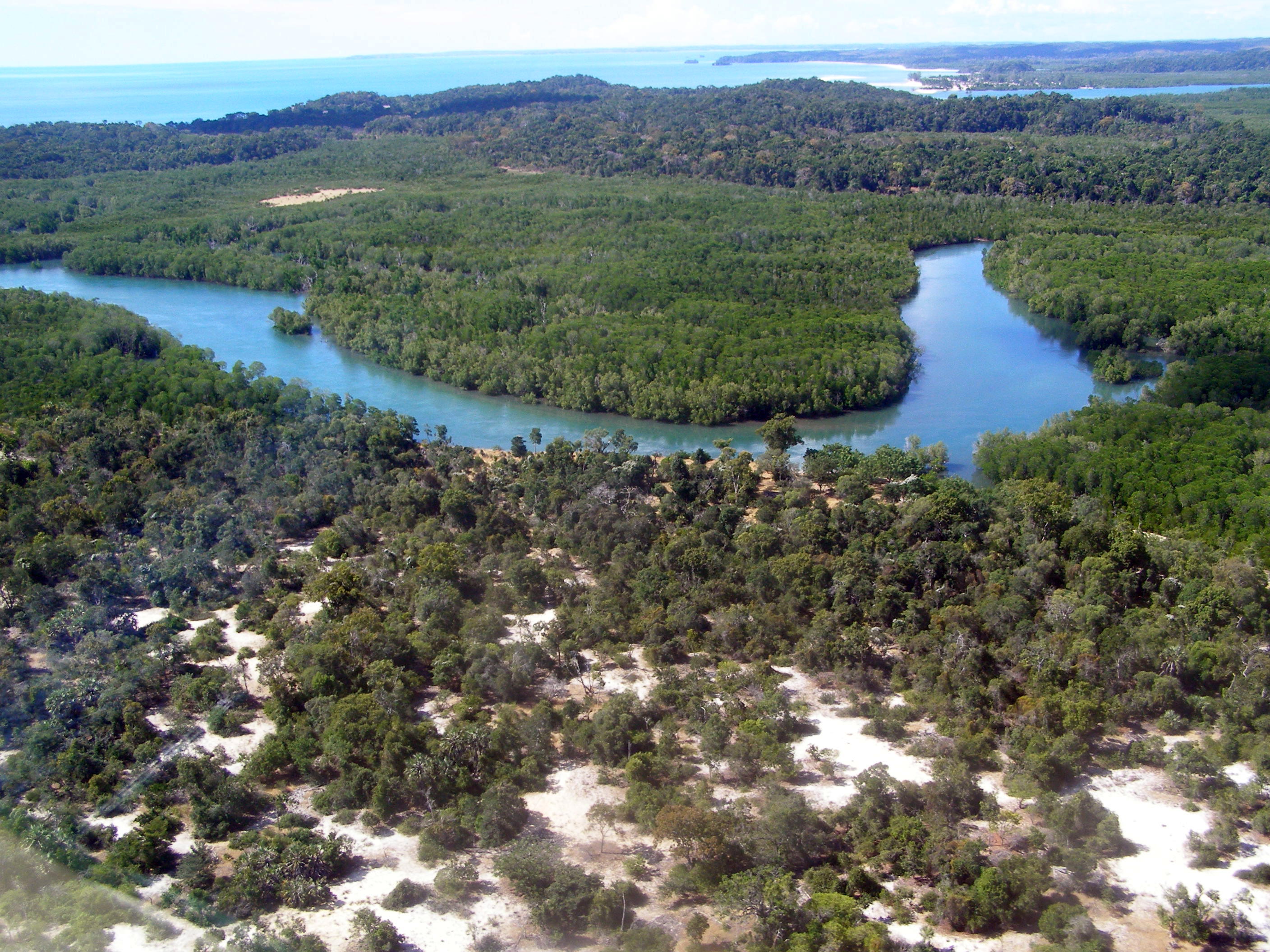
The Mangrove Shield
Anjajavy's protected area is flanked to the north and west by three broad mangrove systems and their winding tidal channels. These are not peripheral features but the forest's immune system. The mangroves serve simultaneously as a windbreak against salty ocean air, a firewall against brush fires, a moisture buffer during the dry season, and a filter that keeps coastal turbidity from degrading nearshore waters. Their tangled root systems stabilize soft soils and protect the coastline from erosion. More than 134 bird species have been documented in the protected area, many of them dependent on the mangrove-forest edge. The mangrove channels also double as transportation routes, offering the most practical way to explore a landscape that is otherwise accessible only by unpaved provincial road from Antonibe. Beneath the surface, mangrove sediments capture carbon at rates up to fifty times greater than tropical forests - making these muddy, insect-heavy waterways among the most efficient carbon sinks on the planet.
From the Air
Located at 15.03S, 47.22E on a peninsula in northwest Madagascar, between Majajamba Bay (south) and Narinda Bay (north), facing the Mozambique Channel. The nearest airport is Mahajanga Amborovy (FMNM/MJN), approximately 150 km to the south. The forest appears as a dark green canopy on a narrow peninsula, bordered by lighter mangrove systems and turquoise water. Moramba Bay's marine tsingy formations - limestone pinnacles rising from the sea - are visible from altitude. Best viewed at 2,000-4,000 feet to appreciate the peninsula's isolation and the contrast between forest, mangrove, and open water.