Anjouan
English sailors once called it Johanna. In 1644, a mutinous East India Company captain named John Mucknell marooned his enemies here before turning pirate and sailing home to Britain. Nearly four centuries later, the island formerly known as Johanna -- now Anjouan, or Ndzuani in the local Shikomori language -- remains a place where ambition and defiance run deep. This 424-square-kilometer volcanic island in the Comoros archipelago has declared independence from its own nation twice, weathered more than twenty coups, briefly operated as an offshore banking haven, and still produces most of the world's ylang-ylang oil, the floral essence found in nearly every perfume on the planet.
The Perfumed Isle
Anjouan's economy runs on scent. Clove trees crowd the island's northeastern slopes, and ylang-ylang plantations spread across the lowlands near Sima, giving the entire Comoros archipelago its old nickname: the Perfume Islands. Over eighty percent of the workforce farms these aromatic crops alongside vanilla, and the island stands as the world's primary exporter of ylang-ylang oil. But the fragrance conceals a harder reality. Rice, the dietary staple, is entirely imported. The Comorian franc, printed by the Bank of France, circulates in an economy where agriculture is nearly everything and alternatives are few. In the early 2000s, Anjouan tried to reinvent itself as an offshore banking center, licensing more than 300 shell banks -- none of which had any physical presence on the island. The Central Bank of the Comoros never recognized a single one.
Sultans, Slavers, and Sovereignty
The first people to settle Anjouan were Bantu-speaking peoples from the African coast and navigators from Indonesia and Southwest Asia. By the late fifteenth century, Hadrami Arab immigrants had married into the ruling classes and established a sultanate that controlled the island and sometimes extended its reach to neighboring Moheli and Mayotte. In 1812, Sultan Alawi bin Husain asked Britain for help against Malagasy slavers raiding his shores. Britain declined, but kept the island within its sphere of influence for decades. France moved in instead, establishing a protectorate in 1886, abolishing slavery in 1899, and formally annexing the island in 1912 after the last sultan was forced to abdicate. When the Comoros gained independence in 1975, Anjouan joined reluctantly -- and has been trying to leave ever since.
A Habit of Secession
In 1997, Anjouan and neighboring Moheli declared independence from the Comoros. A referendum returned over 99 percent in favor. The breakaway government asked France to take the island back; France refused. For the next decade, Anjouan operated as a quasi-independent state under a series of leaders, adopting its own constitution in 1998 and building up a gendarmerie and militia under President Mohamed Bacar. When Bacar declared independence again in 2007, the African Union ran out of patience. In March 2008, Comorian forces backed by 400 AU troops invaded from the staging ground of Moheli. The operation ended Bacar's rule, though not before a French military helicopter on a clandestine mission from Mayotte crashed in the Mozambique Channel near the city of Sima -- an incident critics alleged was an attempt to spirit Bacar into exile.
Volcano, Forest, and Black Sand
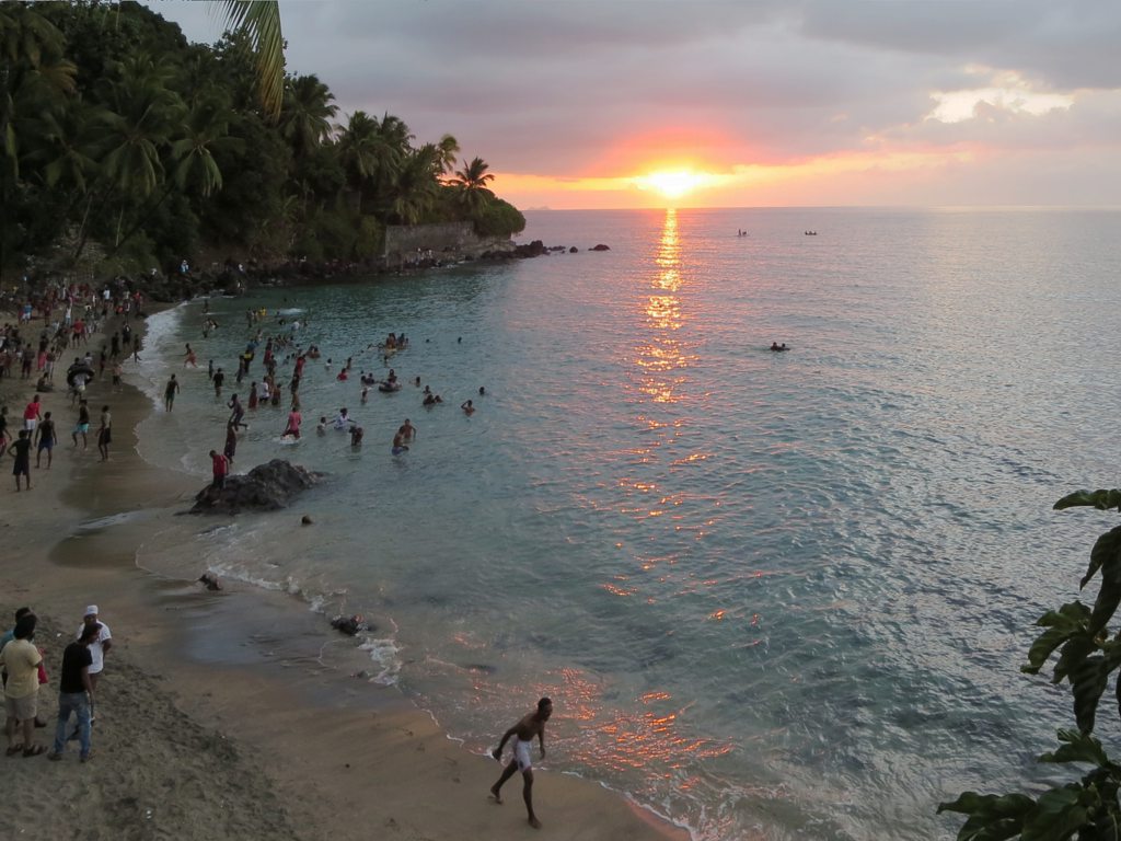
Anjouan is the eroded remnant of a Pleistocene shield volcano whose eruptions pushed outward in three directions before a long quiet interval allowed deep valleys to carve into the slopes. Mount Ntringui rises 1,595 meters above sea level at the island's center, the highest point in the Comoros. The national park surrounding it, established in 2010, protects Lake Dzialandze, the Moya Forest -- Anjouan's largest remaining tract of trees -- and habitat for the rare Anjouan scops owl, lemurs, and the Comoro thrush. Below the mountains, black sand beaches ring the coast. The marine waters around the Sima Peninsula are protected as Shisiwani National Park, sheltering coral reefs in nearly 65 square kilometers of ocean. Approaching by air, the island's single runway at Ouani stretches just 1.5 kilometers along the bay.
Red Cloth and Ground Pepper
Anjouan is the most densely populated island in the Comoros, and its culture reflects layers of African, Arab, and French influence. Women wear the shiromani, a sheet-like wrap often dyed red -- the color of Anjouan. In kitchens across the island, cooks grind fresh peppers on stone to make putu, a hot sauce whose flavor varies from family to family and village to village. Cassava leaves stewed in coconut milk with rice -- a dish called mataba -- is as common as fish with coconut rice. Children learn Arabic and French in school, but daily life unfolds in Shindzuani, a dialect of Shikomori so different from the language spoken on the capital island that linguists debate whether they are truly the same tongue. Jackfruit, breadfruit, lychee, and guava grow everywhere, and at the beach of Moya, children race down a hillside pass on homemade soapbox carts.
From the Air
Located at 12.22°S, 44.43°E in the Mozambique Channel between Madagascar and the African mainland. The island is a compact volcanic landmass visible from altitude as a dark green triangle with steep terrain. Ouani Airport (FMCV) has a 1.5 km runway on the northeast coast. Approach over turquoise waters with coral reefs visible around the Sima Peninsula. Neighboring islands Moheli and Grande Comore are visible to the northwest. Best viewed at 5,000-8,000 ft for the full volcanic profile.