Anza, California
The valley was called Cahuilla for most of recorded history, reflecting the people who had lived there for more than 2,000 years. In September 1926, Riverside County renamed it Anza, after the Spanish commander Juan Bautista de Anza, who first passed through on March 16, 1774. A place that had existed under its indigenous name for millennia was renamed for a colonial visitor who spent perhaps a few days there. This is one of the quieter historical facts about the community of Anza, California — a small valley town at 3,921 feet in the Santa Rosa Mountains, where the comedian Red Skelton once kept a horse ranch and where the Pacific Crest Trail runs through on its way from Mexico to Canada.
Cahuilla Country
The Cahuilla people have inhabited the Anza Valley and surrounding territory for at least 2,000 years, living in a landscape shaped by the larger geography of ancient Lake Cahuilla. This immense inland sea, fed by the Colorado River, covered much of what is now the Salton Sea and extended into the surrounding valleys. Lake Cahuilla evaporated around 1580, leaving behind the remnant body of water that became the Salton Sea after a different flooding event in 1905. The Cahuilla's territory extended across this entire region, from the mountains to the desert lowlands, with the Anza Valley serving as a cooler, higher-elevation zone within their range. Their knowledge of the landscape — its water sources, plant resources, seasonal cycles — represented thousands of years of accumulated understanding that Spanish expeditions glimpsed briefly and could not replicate.
De Anza's March
On March 16, 1774, Juan Bautista de Anza passed through the valley that would bear his name 152 years later. He was on his first overland expedition from Sonora, Mexico, to Alta California, proving that a land route to the California missions was possible. The Anza Valley lay on his route through the mountains — a high-elevation corridor that offered cooler conditions and better water than the desert lowlands to the east. De Anza documented what he found with the systematic precision of a military officer: the terrain, the water sources, the potential for livestock grazing. His route is now the Juan Bautista de Anza National Historic Trail, and the Pacific Crest Trail passes through the same mountain corridors that de Anza's expedition navigated, connecting modern long-distance hikers to a landscape that has been crossed by determined travelers for centuries.
Red Skelton's Ranch
Red Skelton — the rubber-faced comedian who was one of television's most popular entertainers from the 1950s through the 1970s — owned a horse ranch in the Anza Valley. Skelton's connection to the area was genuine rather than purely recreational: he maintained the ranch as a working operation. The comedian, known for characters including Freddie the Freeloader and Clem Kadiddlehopper, found something in the valley's mountain character that drew him back repeatedly. For a community of modest population in a rural mountain valley, a celebrity connection is the kind of local fact that gets remembered and repeated. In Anza, it has become part of the town's informal biography.
Mountain Life at Elevation
Anza sits at 3,921 feet — high enough that winter brings real cold and occasional snow, temperatures that distinguish it sharply from the Coachella Valley just to the north and the Colorado Desert to the east. The population of approximately 3,075 people (2020 census) lives in a rural community that retains an agricultural character alongside the outdoor recreation that the Pacific Crest Trail and surrounding mountain terrain attract. The valley floor supports ranches and small farms; the surrounding mountains draw hikers and horse riders. The Cahuilla Band of Indians, a federally recognized tribe who relocated to the Anza area in 1875, maintains their reservation nearby, carrying the community's longest continuous human presence into the present.
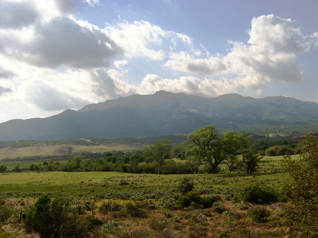
From the Air
Anza, California sits at 3,921 feet elevation at 33.555°N, 116.674°W in the Santa Rosa Mountains of Riverside County, approximately 40 miles west of Palm Springs. The Anza Valley is visible from altitude as a pastoral mountain valley, with the Pacific Crest Trail route visible as a thread through the mountain terrain. The community is surrounded by the Santa Rosa and San Jacinto Mountains National Monument. Ramona Airport (KRNM) is approximately 45 miles to the southwest; Palm Springs International Airport (KPSP) is about 40 miles to the northeast. Mountain flying considerations apply: turbulence, updrafts near ridges, and rapidly changing visibility with cloud development. Winter icing possible above 4,000 feet.