Aoraki / Mount Cook National Park
Twenty-two of New Zealand's 23 peaks above 3,000 metres stand inside a single park. Aoraki / Mount Cook National Park, established in 1953 and covering 707 square kilometres, is not just a collection of summits but an entire vertical world, from the milky terminal lakes where icebergs calve off retreating glaciers to the wind-blasted ridgelines where only the toughest mountaineers venture. It is part of the Te Wahipounamu UNESCO World Heritage site, and getting here requires commitment: three to four hours of driving from either Christchurch or Queenstown, through landscapes that grow steadily more dramatic with every kilometre.
Ice and Stone
The Tasman Glacier, New Zealand's longest, anchors the park's eastern flank. It has been retreating for decades, leaving behind a growing terminal lake dotted with icebergs that look startlingly blue against the grey moraine walls. Boat and kayak tours take visitors among these floating fragments, close enough to hear them crack and shift. Higher up, the glaciers still grip the mountains in earnest. Ski touring from alpine huts, day skiing on the Tasman Glacier itself, and heliskiing in the Ben Ohau and Liebig Ranges draw winter visitors who want their snow without the groomed runs of commercial resorts. For those who prefer to look rather than slide, scenic flights over the Southern Alps to the West Coast trace the spine of the divide, and some planes land directly on the glacier's upper snowfields.
Three Swing Bridges to the Mountain
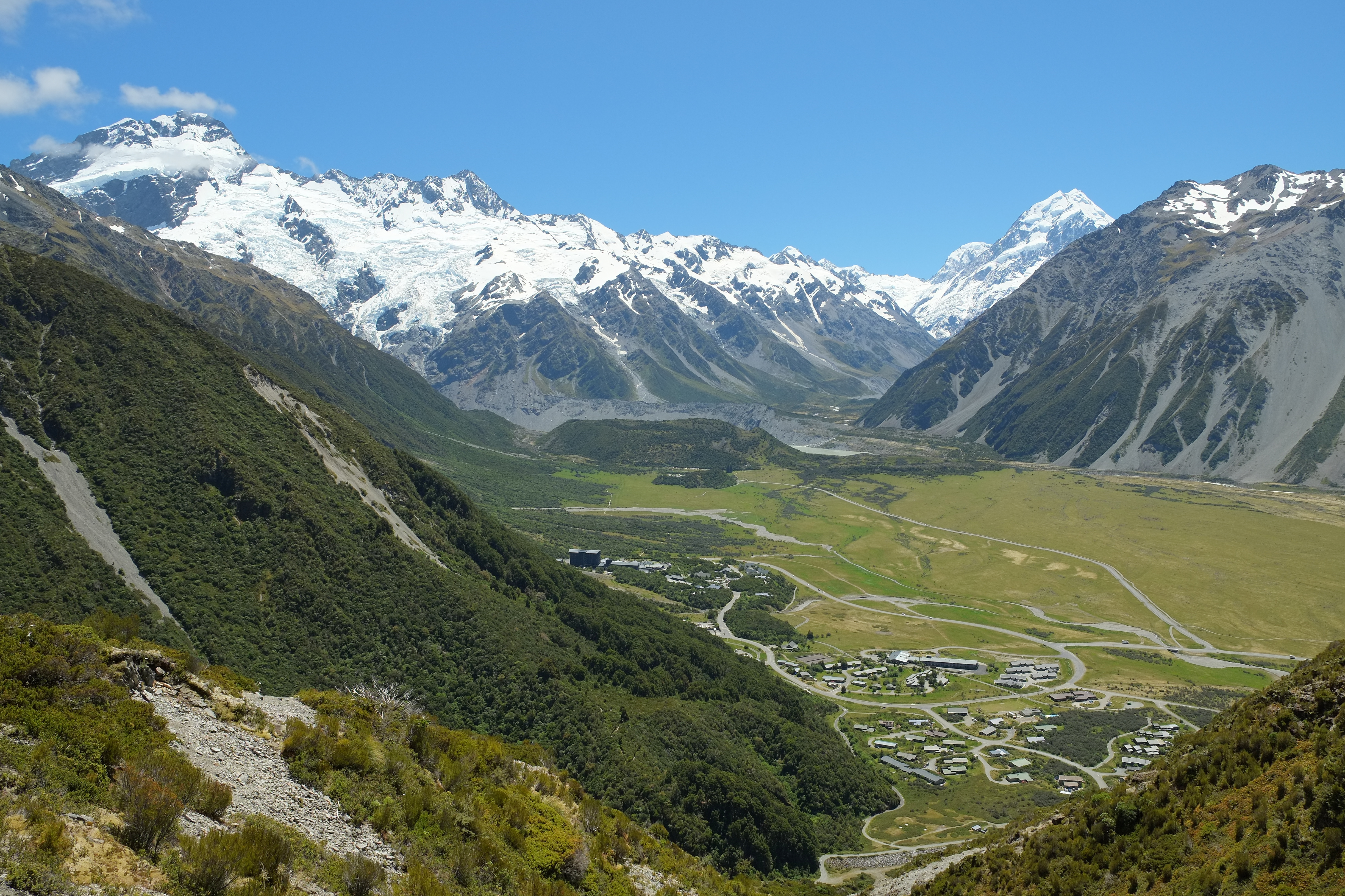
The Hooker Valley Track is the park's most walked route, and for good reason. Starting from White Horse Hill Campground, the 10-kilometre return trail crosses three swing bridges and follows the valley floor directly toward the face of Aoraki / Mount Cook. Lake Muller appears along the way, backed by the enormous terminal moraine of the Mueller Glacier. At the trail's end, Hooker Lake spreads out beneath the mountain's south face, a scene of such scale that the eye struggles to calibrate distance. The walk takes roughly three hours and requires no technical ability, which makes it unusual in a park where much of the terrain demands crampons, ice axes, and experience. Mueller Hut, perched at 1,800 metres, offers a more serious overnight option with views that reward the steep climb. The Ball Pass crossing requires full mountaineering gear and a guide for most parties.
Where Hillary Trained
Sir Edmund Hillary, who in 1953 would become one of the first two people confirmed to reach the summit of Everest, cut his teeth in these mountains. He made his first ascent of Aoraki / Mount Cook in January 1948, and the following month he pioneered a new route up the South Ridge to the Low Peak. That ridge was renamed Hillary Ridge in 2011. The Sir Edmund Hillary Alpine Centre at the Hermitage Hotel now hosts climbing courses and stargazing tours, linking the park's mountaineering heritage to its other great asset: some of the clearest skies in the Southern Hemisphere. The park's remoteness and the absence of city light pollution make the night sky here extraordinary, a canopy of stars visible in a density that many visitors from urban centres have never experienced.
Weather as Gatekeeper
The park's brochures carry a consistent warning: weather here changes fast. Even summer day-walkers are advised to carry warm clothing and high-energy food, because a sunny morning can become a cold, wet afternoon with little notice. For tramping and climbing parties, the stakes rise sharply. Intention plans must be lodged with park rangers, and parties should be prepared to spend an unplanned night in the open. Weather conditions can delay search and rescue efforts, so self-sufficiency is not a suggestion but a requirement. The road in is equally demanding of respect. Some tracks in the park, notably the Balls Hut Road, are so treacherous that vehicle insurance policies explicitly exclude them. In winter, snow chains are essential. The difficulty is the point, in a sense: this is wilderness that has not been softened for convenience, and the mountain makes no concessions.
From the Air
Located at 43.73S, 170.10E. The park spans 707 square kilometres of the central Southern Alps. Aoraki / Mount Cook (3,724 m) is the dominant peak, flanked by Mount Tasman. The Tasman Glacier is clearly visible from the east. Mount Cook Aerodrome is located near the village. Queenstown Airport (NZQN) is the nearest major airport, approximately 3-4 hours by road. Expect orographic cloud and turbulence along the Main Divide. Scenic flights operate from Glentanner Park. Best overflown at or above 12,000 ft for safe terrain clearance.