Apostle Islands
There are twenty-two of them, not twelve. French historian Pierre Francois Xavier de Charlevoix named them after the twelve apostles, counting only the largest islands and rounding down in a moment of either haste or devotion. The actual number hardly matters when you see them from above: a broken necklace of forested sandstone draped across the southwestern corner of Lake Superior, off Wisconsin's Bayfield Peninsula. The Ojibwe called the largest island Mooningwanekaaning -- home of the golden-breasted woodpecker -- and made it the capital of a nation that controlled the entire Lake Superior basin. The sandstone beneath these islands is over 500 million years old, deposited by ancient rivers long before anything resembling a Great Lake existed. What the glaciers and waves have carved from that stone since then ranks among the most extraordinary geological art on the continent.
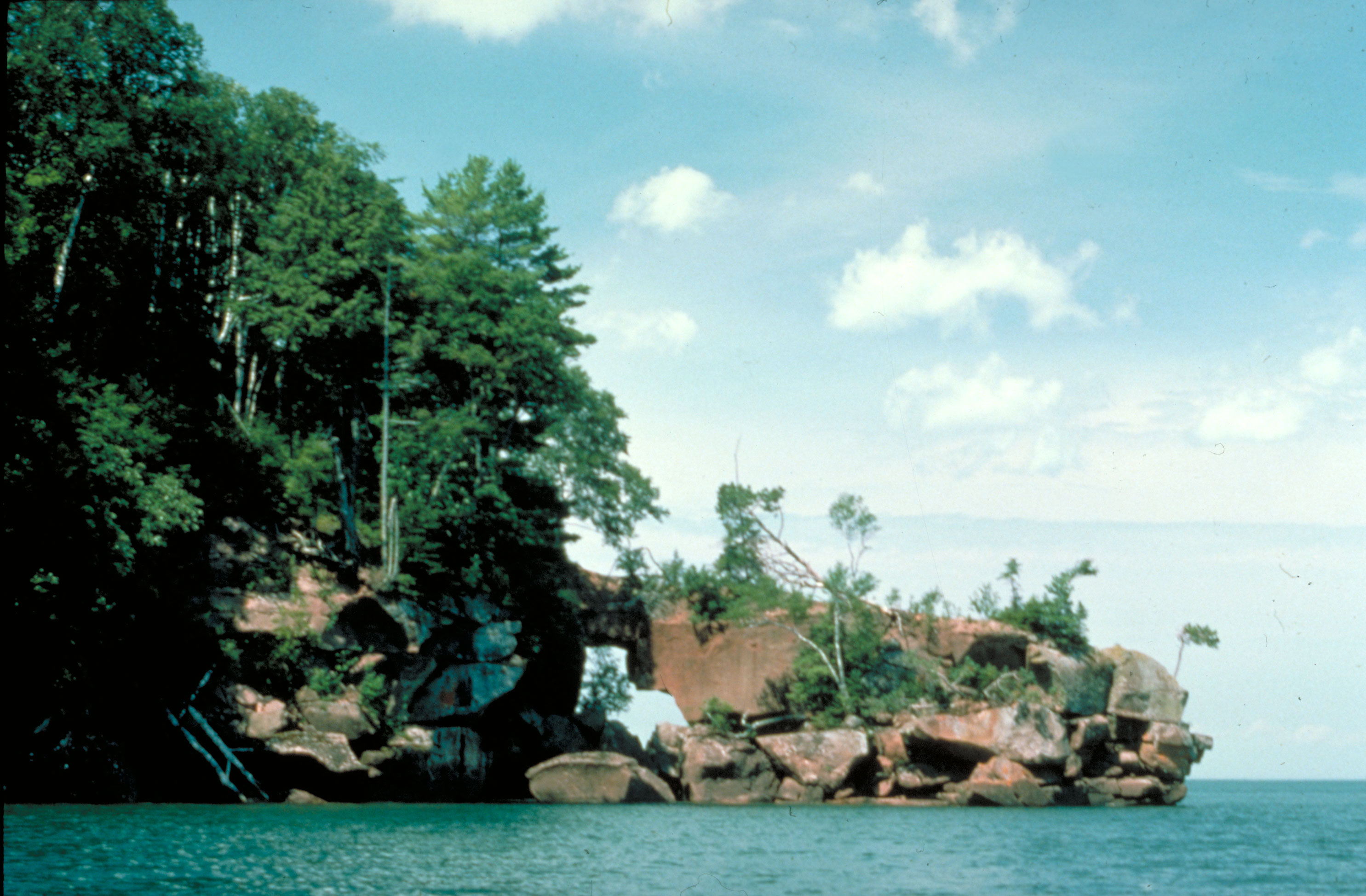
Stone Cathedrals at the Waterline
The sea caves of the Apostle Islands are the defining spectacle of this archipelago. At Swallow Point on Sand Island, along the north shore of Devils Island, and near Mawikwe Bay on the mainland, Lake Superior's relentless waves have hollowed the ancient sandstone into arches, chambers, and honeycombed galleries. The red and gold strata -- laid down layer by layer over hundreds of millions of years -- create natural murals on cave walls. In summer, kayakers paddle through openings barely wide enough for a boat, entering rooms where light filters through overhead cracks. In winter, these same caves transform entirely. Frozen waterfalls cascade down cliff faces, and the chambers fill with delicate icicles that refract whatever light reaches them. Some winters, Lake Superior freezes solid enough near shore that the National Park Service opens a path from Meyers Beach, allowing visitors to walk across the ice and enter the caves on foot -- an experience that draws thousands.
Mooningwanekaaning, Capital of the Ojibwe
Archaeological evidence places human activity on these islands as early as 100 BC, but the story that shaped the region began around 950 AD. Anishinaabe peoples, migrating westward from the Atlantic coast along ancient trade routes, followed the waterways into the heart of the continent. When they reached the shallow marshes of Chequamegon Bay and discovered wild rice growing in abundance, they established their capital on what is now Madeline Island. Settlements spread to Stockton and Manitou Islands and along the mainland shore. The Ojibwe innovated agricultural techniques here -- copper tool making, canoe-based rice harvesting, and the Three Sisters crop complex of corn, beans, and squash -- expanding their territory and population into one of the largest nations in the region. Details of these migrations were recorded on birch bark scrolls, some of which are now preserved at the Smithsonian. Madeline Island remained the cultural and spiritual center of the Ojibwe world even as political power shifted outward.
Chief Buffalo's Diplomatic Stand
When French traders arrived around 1640, they named the capital La Pointe. By 1693 it was a fortified trading post in the Empire of New France. But European colonialism brought escalating conflict. By 1811, Chief Buffalo of La Pointe had assembled an Ojibwe army to join Tecumseh's War against the United States. Before reaching the battlefield, he met Michel Cadotte in Sault Ste. Marie, who convinced him that diplomacy might achieve what warfare could not. Chief Buffalo spent the next four decades in a different kind of fight -- resisting the United States government's repeated attempts to remove the Ojibwe from their homeland entirely. Mining and lumber interests pushed relentlessly for removal, and the consequences of forced relocations proved sometimes deadly. Yet Chief Buffalo persevered, ultimately securing permanent land reserves, including the mainland coastline nearest the islands for the Red Cliff Band of Lake Superior Chippewa. The American flag had flown over the islands since 1816, but the Ojibwe never fully left.
An Archipelago of Wings and Waves
Twenty-one of the twenty-two islands now form the Apostle Islands National Lakeshore. Only Madeline Island, the largest and most populated, remains outside the park boundary. The lakeshore shelters over 800 plant species, including Wisconsin-listed endangered and threatened species found nowhere else in the region. Gull and Eagle Islands together support 88 percent of the lakeshore's breeding herring gull population and 80 percent of the herring gull breeding population along Wisconsin's entire Lake Superior shoreline. Eagle Island holds the park's only great blue heron rookery. Double-crested cormorants, ring-billed gulls, cliff swallows, and peregrine falcons also nest throughout the archipelago. The islands themselves range from tiny rocky outcrops to Madeline's 14,000 acres of forest, historic buildings, and year-round community. In 2018, the Apostle Islands were selected as Wisconsin's entry for the America the Beautiful quarters series -- a fitting tribute to a place where deep time, indigenous history, and wild beauty converge.
From the Air
Located at 46.965N, 90.664W in Lake Superior off Wisconsin's Bayfield Peninsula. The 22-island archipelago spreads across roughly 720 square miles of open water. Best viewed from 3,000-6,000 feet AGL for island grouping perspective; drop to 1,500-2,000 feet to appreciate sea cave formations along Devils Island and Sand Island shorelines. John F. Kennedy Memorial Airport (KBFW) in Bayfield is the nearest field, approximately 8nm south. Ashland/JFK Memorial Airport (KASH) also serves the area. Madeline Island, the largest, is easily identified by its ferry dock and settlement at La Pointe. Lake effect weather can reduce visibility rapidly; approach from the south via the Bayfield Peninsula for best orientation. The red sandstone cliffs are most visible in morning light from the east.