Apostle Islands National Lakeshore
One of the twenty-two Apostle Islands no longer exists. Historical sources from August 1901 document the disappearance of Steamboat Island, a small landmass alongside Eagle Island that vanished due to unknown natural forces -- swallowed by the same Lake Superior waves that have been sculpting this archipelago for millennia. That the lake can simply erase an island says everything about the power at work here. The Apostle Islands National Lakeshore encompasses 21 of the remaining islands plus a strip of mainland shoreline, totaling 42,308 acres of land and 27,232 acres of water along 155 miles of coast. The rock is Precambrian sandstone, deep red, shaped by glaciers into cliffs that the lake has hollowed into sea caves. From above, the islands scatter across the blue-black water like fragments of a continent that shattered and drifted apart.
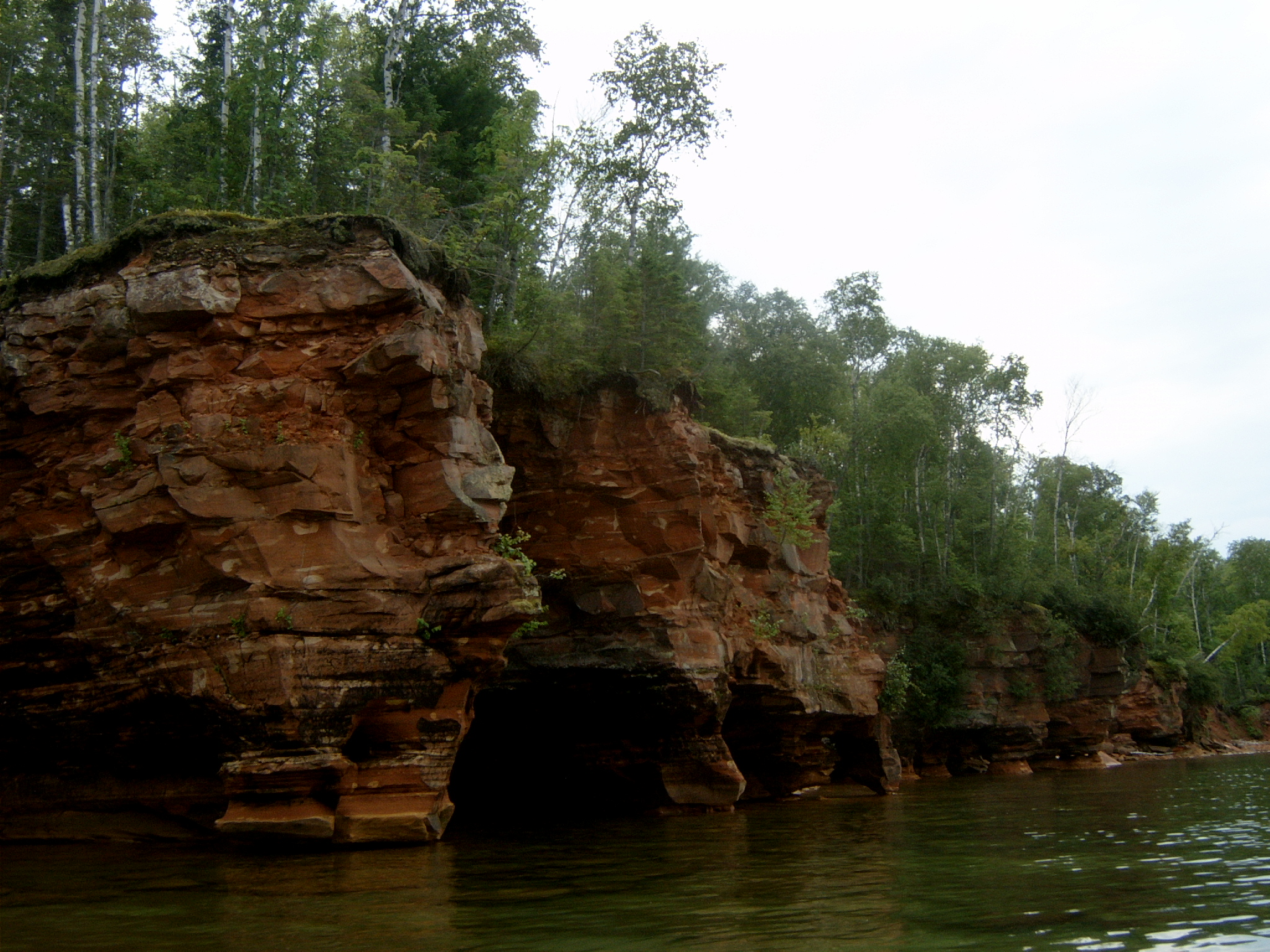
What the Glaciers Left Behind
The Apostle Islands exist because of ice. They sit at the edge of a great rift or fault that formed the basin where Lake Superior's waters collected as the glaciers retreated. The islands are composed of red sandstone -- Precambrian rock deposited roughly a billion years ago and exposed when the ice sheets scraped away overlying layers. Since then, Lake Superior's waves have been the dominant sculptor, eroding the sandstone into sea caves, arches, and pillars along the island coastlines. The resulting sand has built spits, tombolos, barrier beaches, and cuspate forelands that give each island a distinct silhouette. Over 800 plant species thrive across the archipelago, blending elements of eastern hardwood forest with the boreal forest of Ontario. Black bear, whitetail deer, red fox, beaver, and otter share the islands, while bald eagles and ruffed grouse occupy the canopy and forest floor.
Eight Beacons on Six Islands
The Apostle Islands National Lakeshore holds more lighthouses than any other National Park Service area: eight historic towers on six islands. For well over a century, these beacons have guided ships through Lake Superior's notoriously rough waters and through the maze of channels between the islands. The Sand Island lighthouse, one of the first to be automated in 1922, draws visitors by boat from June through late August. The Raspberry Island lighthouse has been completely renovated and stands as one of the most scenic in the archipelago. Devils Island Light, Outer Island Light, and both the Old and New Michigan Island Lights complete the collection, along with the New La Pointe Light and Chequamegon Point Light on Long Island. Near that last tower, the ruins of Old La Pointe Light still stand, not far from the wreckage of the schooner Lucerne -- a reminder that these lights were built because the lake demanded them.
From Logging Camps to Wilderness
Before they were parkland, the islands were working landscape. During the early twentieth century, logging operations felled timber across the archipelago. Farmers cleared plots. Quarries cut brownstone from the cliffs. Commercial fishermen operated camps on several islands -- preserved fishing communities still exist on Stockton, Raspberry, and Manitou Islands. The Trout Point Logging Camp on Stockton Island and sandstone quarries on both Stockton and Hermit Islands testify to this industrial past. But the forests have been reclaiming the land for decades. Senator Gaylord Nelson of Wisconsin sponsored the legislation that President Richard Nixon signed on September 26, 1970, establishing the national lakeshore with 20 islands. Long Island was added in 1986. In 2004, Congress designated 80 percent of the land area as the Gaylord Nelson Wilderness -- the largest in Wisconsin -- named for the senator who also helped establish the National Trails System, the Wilderness Act, and Earth Day.
Kayaks, Shipwrecks, and Cold Water
The sea caves are the signature experience. Kayakers paddle into sandstone chambers carved by centuries of wave action, where the rock glows red and amber in reflected light. Scuba divers explore submerged rock formations and shipwrecks scattered across the lakeshore. Camping is available on 18 of the 21 islands, ranging from developed sites with well water and vault toilets to remote clearings offering nothing more than a tent pad and fire ring. Lake Superior's water temperature keeps swimmers honest -- even in summer the offshore water can be bracingly cold. Fishing yields several species of trout and salmon. Bayfield, Wisconsin serves as the gateway community, home to the lakeshore's headquarters and visitor center. The nearby Red Cliff reservation offers a campground and marina. In 2024, legislation was introduced to redesignate the national lakeshore as Wisconsin's first national park, with Sand Island as a national preserve.
From the Air
Located at 46.965°N, 90.664°W in Lake Superior, off the northern tip of Wisconsin's Bayfield Peninsula. The 21 islands of the national lakeshore spread across roughly 720 square miles of lake surface. From 5,000-8,000 feet AGL, the archipelago is spectacular -- red sandstone cliffs, forested islands, and lighthouse towers are visible in clear conditions. John F. Kennedy Memorial Airport (KBFW) in Bayfield is the closest field. Ashland County Airport (KASW) provides an alternative to the south. The Bayfield peninsula provides a clear visual reference for orientation. Sea caves along island shorelines may be visible from lower altitudes. In winter, ice formations on the caves and frozen lake surface create dramatic aerial scenery. Madeline Island, the largest island (excluded from the lakeshore), is immediately identifiable by its size and the community of La Pointe on its southwest tip.