Arachosia
Kandahar was not named for Alexander the Great. For decades, scholars assumed the city's name derived from "Iskanderiya," a corruption of "Alexandria," honoring the Macedonian conqueror who passed through on his campaign toward India. It was a satisfying etymology -- the great man leaving his mark on the map. Then a clay tablet turned up. The inscription proved that Kandahar was already a thriving trade center, dealing actively with Persia, well before Alexander was born. The city's roots reach into something older and deeper: Arachosia, a satrapy of the Achaemenid Empire that stretched from the Arghandab River eastward to the Indus, a territory that was already ancient when the Greeks arrived.
A Province Written in Stone
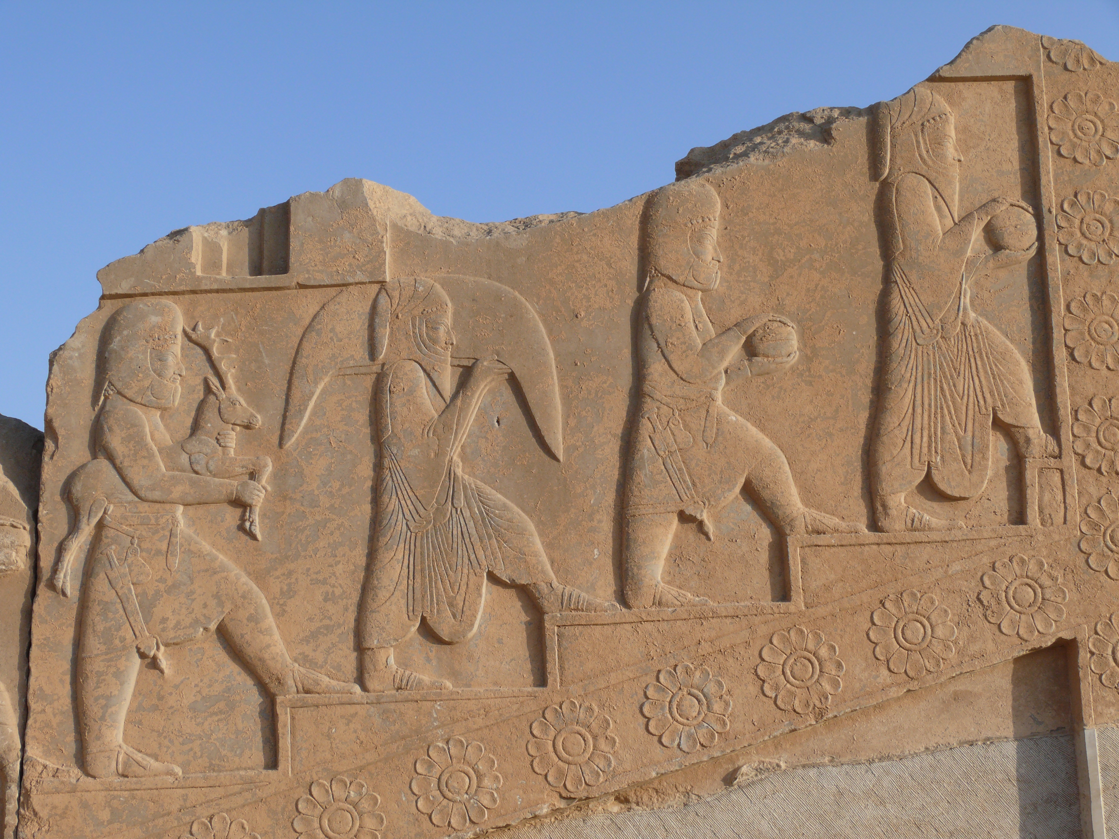
The earliest references to Arachosia appear on the Elamite Persepolis fortification tablets, administrative records of an empire that governed through bureaucracy as much as through force. The region surfaces again in inscriptions carved by Darius I and Xerxes I in Old Persian, Akkadian, and Aramaic -- three languages for an empire that spoke dozens. Arachosia appears in these royal lists alongside other subject peoples and provinces, a name in a catalog of imperial reach. But the Behistun inscription reveals something more personal. Darius records that his governor of Arachosia, a man named Vivana, defeated a Persian rebel three times, keeping the province loyal during a dangerous period of revolt. Scholars have suggested the rebel targeted Arachosia because of its close ties to Zoroastrian religious authority -- a spiritual connection that made the province worth fighting over. The ivory used in Darius' palace at Susa was sourced from Arachosia, evidence of a trade network that moved luxury goods across hundreds of miles of difficult terrain.
The Metropolis That Stayed Greek
Alexander did pass through, of course. He founded a city here -- one of many Alexandrias scattered across his conquests. The Greek explorer Megasthenes lived in Alexandropolis, the capital, from where he traveled east to the court of Chandragupta Maurya in Pataliputra. What is remarkable is how long the Greek character of the city persisted. Isidore of Charax, writing his "Parthian Stations" itinerary in the 1st century CE -- roughly three centuries after Alexander's death -- described the metropolis of Arachosia as still Greek. The geographer Ptolemy, the historian Strabo, and Pliny the Elder each compiled their own lists of the region's cities. The earlier capital, called Arachotus or Cophen, is identified today with the town of Arghandab, northwest of modern Kandahar. These ancient geographers mapped a world in which Arachosia sat at a crossroads -- Persian administration to the west, Indian trade to the east, Greek culture layered atop both.
Empire After Empire
The parade of conquerors through Arachosia reads like a compressed history of Central Asian power. The Kushans took it from the Indo-Parthians. Around 230 CE, the Sassanids -- Persia's second great empire -- defeated the Kushans and installed their own vassals, the Kushanshas. In 420 CE, the Chionites drove the Kushanshas out and established the Kidarite Kingdom. The Kidarites fell to the Hephthalites in the 460s. A Persian-Turkish coalition broke the Hephthalites in 565. Arachosia passed into the Kushano-Hephthalite kingdoms of Kapisa and then Kabul, before Arab armies brought Islam. Around 870 CE the Saffarids took control, followed by the Samanid Empire and ultimately the Ghaznavids in the early 11th century. Each conquest reshaped the region's language, religion, and trade routes, but the geography remained constant: the Arghandab River valley, fertile enough to sustain cities, positioned squarely on the routes connecting Persia to India.
Names Across Languages
Arachosia collected names the way it collected rulers. In Old Persian cuneiform, the province was Harauvatis, written in wedge-shaped characters on rock faces and clay. The name shares an etymological root with a term from Vedic Sanskrit, a linguistic connection that hints at deep cultural exchange across the Hindu Kush. Arab geographers knew the region as Arokhaj, Rokhaj, or simply Roh. The Chinese pilgrim Xuanzang, passing through in the 7th century, recorded the capital's name as Kaofu. Even the theory linking Arachosia to the origins of the Croatian people -- drawing on similarities between "Arachosian" and "Hrvati" -- speaks to how far the echoes of this region traveled. Whether that theory holds or not, the fact that it exists at all captures something true about Arachosia: it was a place where civilizations met, mixed, and scattered their influence across an improbably wide span of the ancient world.
From the Air
Located at 30.02N, 64.79E in southern Afghanistan, centered on the Arghandab River valley near modern Kandahar. The terrain is arid with irrigated river valleys cutting through desert plateau. Kandahar International Airport (OAKN) is approximately 15 km southeast. The Arghandab River is a visible landmark from altitude, winding through otherwise barren terrain toward the Helmand River. Best viewed from 8,000-12,000 feet AGL, where the contrast between the green river valley and the surrounding desert steppe illustrates why this corridor sustained cities for millennia. The Sulaiman Mountains are visible to the east.