Arai Barrier
Every traveler on the Tokaido -- samurai, merchant, pilgrim -- stopped here. There was no choice. The Arai Barrier straddled the narrow spit of land between Lake Hamana and the Pacific Ocean, and for nearly 270 years it served as one of the Tokugawa Shogunate's most important security checkpoints. Officials inspected travel permits, levied taxes on goods, and scrutinized anyone attempting to pass between the shogun's capital of Edo and the imperial seat of Kyoto. Today it holds a rare distinction: it is the only Edo-period checkpoint building still standing in all of Japan, recognized as a Special National Historic Site since 1962.
Gatekeepers on the Narrow Shore
The checkpoint's location was no accident. Positioned between the post towns of Maisaka-juku and Arai-juku in what is now Kosai, Shizuoka Prefecture, the barrier commanded a geographic bottleneck where the waters of Lake Hamana nearly touch the Pacific surf. Unlike every other checkpoint along the Tokaido, the Arai Barrier controlled passage both by land and by water -- travelers arriving by boat across the lake were subject to the same rigorous inspections as those on foot. A hatamoto official with a revenue of 1,000 koku oversaw operations, assisted by six yoriki and twenty doshin. From 1696, two men rotated the post in alternate years, until Yoshida Domain assumed management in 1702 on behalf of the shogunate.
Shaken but Never Broken
The Arai Barrier has a turbulent relationship with the earth itself. The original checkpoint, constructed in 1600 -- the same year Tokugawa Ieyasu won the Battle of Sekigahara and secured his grip on Japan -- was destroyed by a tsunami during the Genroku period. Rebuilt, it was flattened again by the devastating 1707 Hoei earthquake, one of the most powerful seismic events in Japanese history. The barrier was then relocated to its present position on the western shore of Lake Hamana. Even this was not the end: the 1854 Ansei-Tokai earthquake forced yet another reconstruction. Each time, the shogunate rebuilt. The checkpoint was too strategically important to abandon, and each rebuilding reinforced its role as one of the most critical chokepoints on the great eastern road.
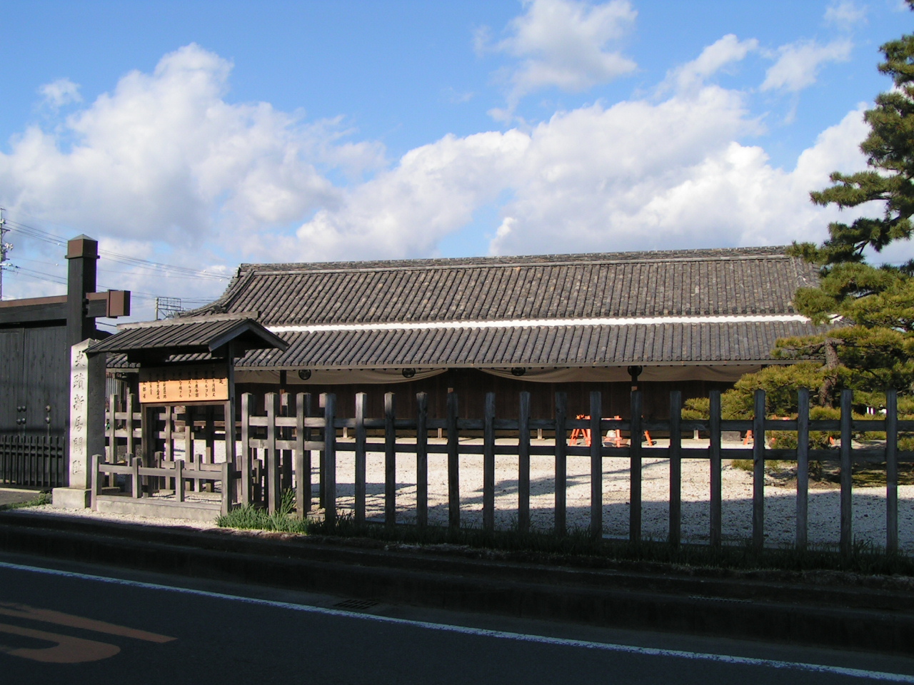
The Architecture of Control
The surviving main building is a single-story structure facing south, built in the irimoya style with gambrel-shaped sides and a tiled roof. It stretches long from east to west, divided into several rooms where officials processed the endless stream of travelers. The architecture was designed for function over beauty: clear sightlines, controlled access points, rooms for interrogation and document inspection. After the Meiji Restoration swept away the feudal order in 1869, the barrier was abolished. Its buildings found new life as an elementary school and later as government offices, serving the community until 1951. This adaptive reuse likely saved the structure from demolition.
From Checkpoint to Living Museum
Restoration of the main building came in 1971, and in 1998, gates and a pier were faithfully recreated on their original foundations as part of a museum complex. The artist Hiroshige immortalized this stretch of the Tokaido in his famous ukiyo-e woodblock print series, The Fifty-three Stations of the Tokaido, depicting travelers approaching Arai with the waters of Lake Hamana glittering beyond. Walking through the checkpoint today, visitors pass through the same gates that once filtered the human traffic of an entire nation. The rooms where officials once demanded papers now hold exhibits explaining the elaborate system of travel control that kept the Tokugawa peace for over two and a half centuries.
From the Air
Located at 34.695N, 137.561E on the shore of Lake Hamana in Kosai, Shizuoka Prefecture. From the air, look for the distinctive shape of Lake Hamana -- a large brackish lagoon connected to the Pacific by a narrow inlet. The barrier site sits on the narrow coastal strip between the lake's southern shore and the ocean. Nearest major airport is RJNS (Mt. Fuji Shizuoka Airport) approximately 60 km to the northeast. Chubu Centrair International Airport (RJGG) lies about 80 km to the west across the bay. Best viewed at 3,000-5,000 feet AGL for context of the geographic bottleneck between lake and sea.