Arai-juku
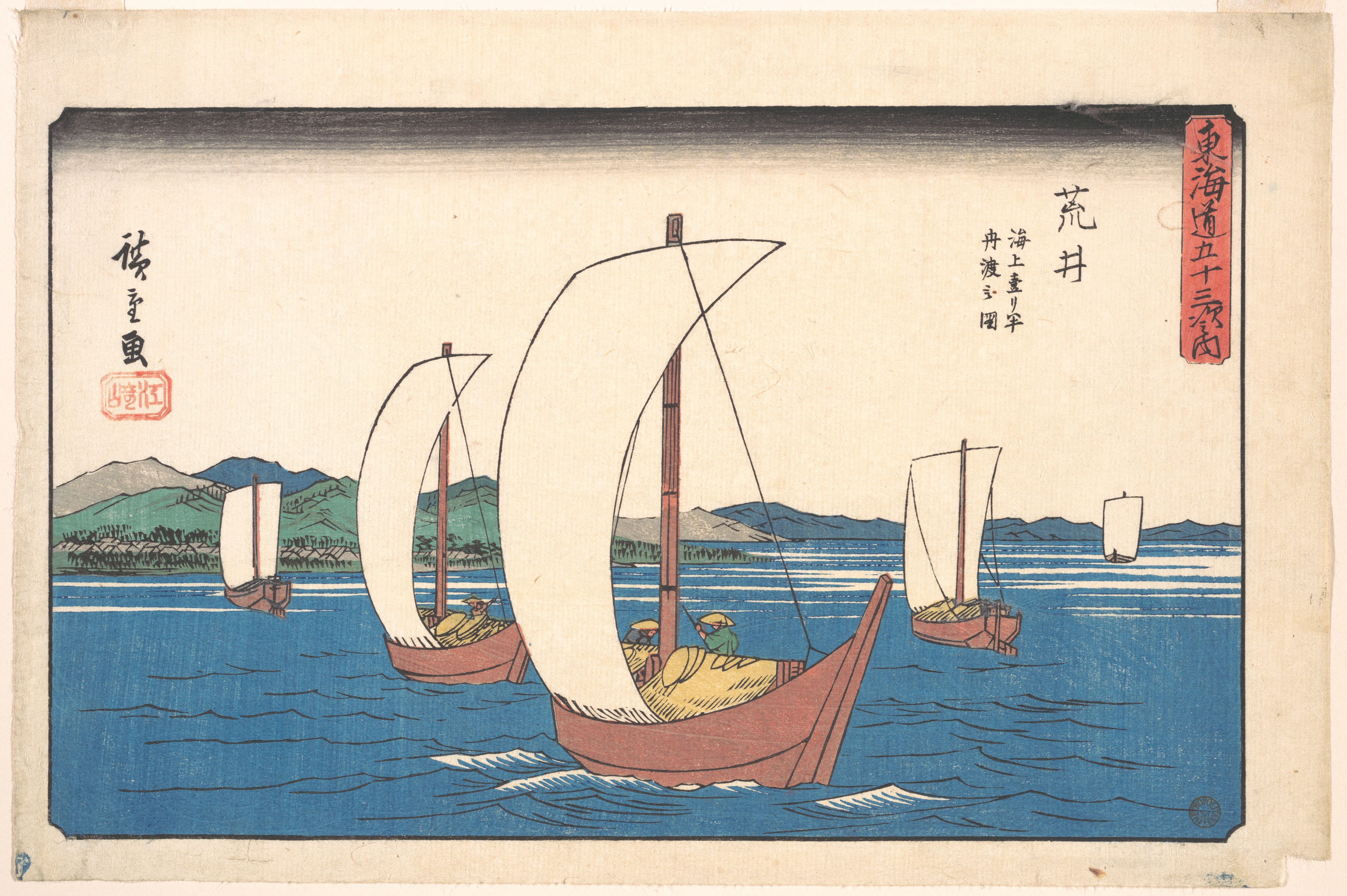
Hiroshige painted the scene between 1833 and 1834: a daimyo's grand vessel cutting across the waters of Lake Hamana, its lord's family crest billowing on the sail, a smaller boat trailing behind with retainers and baggage. This was Arai-juku as travelers knew it -- not a station you walked through, but one you sailed to. The thirty-first of the fifty-three stations on the great Tokaido road, Arai-juku was unique among all the post towns that linked Edo to Kyoto. Here, the highway met the water, and the only way forward was by boat.
Where the Road Becomes Water
Arai-juku sat on the western shores of Lake Hamana in what is now Kosai, Shizuoka Prefecture. During the Edo period, the town belonged to Totomi Province. Travelers heading east toward Edo had to board boats here to cross the lake and reach Maisaka-juku, the next station on the Tokaido. This lake crossing made Arai-juku one of the most distinctive stops on the entire highway. The post station's name was written with various kanji over the centuries -- sometimes as荒江, sometimes as 荒井 -- but its identity was always tied to the water. The Arai Checkpoint, located here, was the only barrier station on the Tokaido that operated both on land and on the lake, inspecting travelers arriving by either route.
Shaken Ground, Shifting Shores
The geography that made Arai-juku strategically important also made it dangerously vulnerable. Earthquakes and tsunamis repeatedly damaged both the post station and its checkpoint, forcing relocations over the centuries. The current site was established after the catastrophic earthquake of 1707, which reshaped the very shoreline of Lake Hamana. The checkpoint building survived the upheavals long enough to find a second life: after the barriers were abolished at the start of the Meiji period, the structure was converted into a school. Today it stands as a museum dedicated to the history and culture of the Tokaido's post stations, preserving the routines and rituals of highway travel in feudal Japan.
Rest for the Road-Weary
Beyond the checkpoint, Arai-juku offered what every post town on the Tokaido promised: rest, food, and shelter. A preserved hatagao -- a type of official rest house -- still stands today, a reminder of the hospitality infrastructure that sustained travelers across hundreds of miles. This particular establishment served official travelers arriving from Kii Province to the south, offering a place to eat and sleep before continuing the journey. It has been converted into a local history museum, its rooms now displaying the artifacts and documents of a travel system that moved an entire nation along a single road. Between Maisaka-juku to the east and Shirasuka-juku to the west, Arai-juku was a critical link in a chain of fifty-three stations that defined Japanese travel for centuries.
Immortalized in Woodblock
Arai-juku's most enduring image comes from Ando Hiroshige's celebrated ukiyo-e print series, The Fifty-three Stations of the Tokaido. In the Hoeido edition, published between 1833 and 1834, Hiroshige chose to depict the lake crossing itself: a daimyo on sankin-kotai -- the mandatory procession that feudal lords were required to make to the shogun's capital -- sailing between Maisaka-juku and Arai-juku. The lord rides in a large vessel emblazoned with his family crest, while his retainers follow in a smaller boat loaded with baggage. The print captures a moment that played out countless times over the centuries: the powerful crossing the waters under ceremony, while the post town waited on the far shore to receive them.
From the Air
Located at 34.695N, 137.561E on the western shore of Lake Hamana, Kosai, Shizuoka Prefecture. From the air, Lake Hamana is unmistakable -- a large brackish lagoon on the Pacific coast with a narrow opening to the sea. Arai-juku sits at the southern end of the lake near the same location as the Arai Barrier. The Tokaido Shinkansen (bullet train) passes through this area, offering a modern contrast to the ancient highway. Nearest major airport is RJNS (Mt. Fuji Shizuoka Airport) about 60 km northeast. RJGG (Chubu Centrair International) is approximately 80 km west. Best viewed at 3,000-5,000 feet AGL to appreciate the lake crossing route that defined this station.