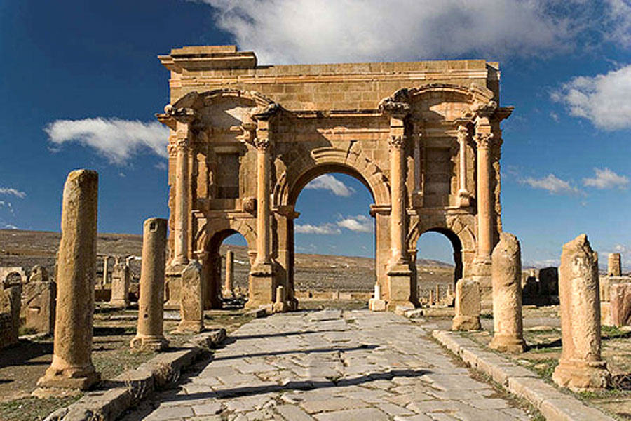
Arch of Trajan (Timgad)
The ruts are still there. Worn deep into the stone beneath the central archway, they record the passage of carts and wagons that rolled through this gateway nearly two thousand years ago. The Arch of Trajan stands 12 meters tall at the western end of Timgad's Decumanus Maximus, a triple-arched monument that once announced to every traveler arriving from Lambaesis that they were entering a city of consequence. The wheels that carved those grooves are long gone, but the arch remains, red Corinthian columns catching the Algerian sunlight exactly as they did when Roman legionaries walked this road.
Gateway to a Grid
The arch composed the western gate of Timgad, the Roman colony founded by Emperor Trajan around 100 AD in the Aures Mountains of what is now Algeria. An inscription on the attic records the colony's founding, though the elaborate decorative program suggests the arch itself was built later, probably between the late 2nd and early 3rd century. Its position was deliberate: anyone approaching from the legionary fortress at Lambaesis would pass through these arches before entering the city's famously perfect grid of streets. The central arch, 6 meters high, admitted vehicles. The two lateral arches, each 3.75 meters, were reserved for pedestrians. It was civic architecture as statement of identity, a city in the Atlas Mountains insisting on its Roman credentials.
Columns of Colored Stone
What distinguishes this arch from simpler provincial gateways is its lavish decoration. Above each lateral arch, deep rectangular niches once held statues, now lost, flanked by small shrines called aediculae with smooth-stemmed Corinthian columns of colored marble set on shelves. Red Corinthian columns, detached from the walls and standing on pedestals, framed each side. The entablature jutted outward above them, supporting curvilinear pediments that gave the facade a sense of movement and depth unusual in North African Roman architecture. The attic likely bore a group of monumental statues, completing a composition designed to impress from a distance.
Gods Added Later
The arch accumulated meaning over time. Under Emperor Septimius Severus, a local notable named Lucius Licinius Optatianus added statues of Mars and Concordia to celebrate his election as flamen-for-life of the colony. These additions suggest that the arch served not just as a gateway but as a kind of civic bulletin board, a place where the city's leading citizens could publicly display their status and devotion. That a North African colonist could hold the title of permanent priest, commission sculpture of Roman gods, and mount them on a monument bearing Trajan's name says everything about how deeply Roman identity had taken root in this corner of the empire.
Standing in Sand
Together with the entire archaeological site of Timgad, the arch was inscribed as a UNESCO World Heritage Site in 1982. It was partially restored in 1900, a project that stabilized the sandstone structure without erasing the evidence of age. The Sahara had, in a sense, preserved the arch by burying the city for centuries. When Scottish explorer James Bruce stumbled upon the ruins in 1765, he found what he called a small town full of elegant buildings. The arch was among them, its columns and pediments still standing above the sand that had swallowed the streets and houses around it. Today it remains the most photographed structure in Timgad, framing the view down the Decumanus Maximus toward a city that has not been inhabited since the 8th century.
From the Air
Located at 35.49N, 6.47E in the Aures Mountains of Algeria, approximately 35 km east of Batna. The ruins of Timgad are visible as a geometric pattern on the landscape at medium altitude. The arch stands at the western end of the main east-west street. Best viewed at 2,000-4,000 feet AGL. Nearest airport: Batna-Mostefa Ben Boulaid Airport (DABT) approximately 35 km west. Terrain is elevated plateau at roughly 1,000 meters above sea level. Clear conditions typical.