Arches National Park
Somewhere between 300 million years ago and yesterday, a quiet alchemy of salt, stone, and time produced more than 2,000 natural arches in this corner of Utah's Canyon Country. No place on Earth contains more. They range from barely-there spans just three feet across to the improbable 306-foot sweep of Landscape Arch, one of the longest natural stone arches anywhere. Delicate Arch, its image gracing Utah's license plates, stands alone on the rim of a slickrock bowl like a sculpture made for no audience at all. In Arches National Park, the desert has been carving its own monuments for millennia, and the work continues - arches forming, arches falling, new ones emerging from fins of Entrada Sandstone that crack, weather, and open to the sky.
How Arches Form
The story begins 300 million years ago when an inland sea evaporated, leaving a salt bed thousands of feet thick. Over epochs, sandstone layers buried the salt. Salt under pressure behaves like liquid, flowing and bulging upward, cracking the overlying rock into parallel fins. Water and ice went to work on these fins, widening cracks, dissolving cement, breaking stone. Where a crack penetrated a fin from both sides, an opening formed. Most openings collapse before they become arches; those that survive long enough for their spans to stabilize join the park's inventory. The youngest arches may be only a few thousand years old. The oldest are approaching their end - Landscape Arch has lost major slabs in recent decades and may collapse within our lifetime. The park is not a museum of finished work but a gallery of sculpture in progress.
The Icon and the Others
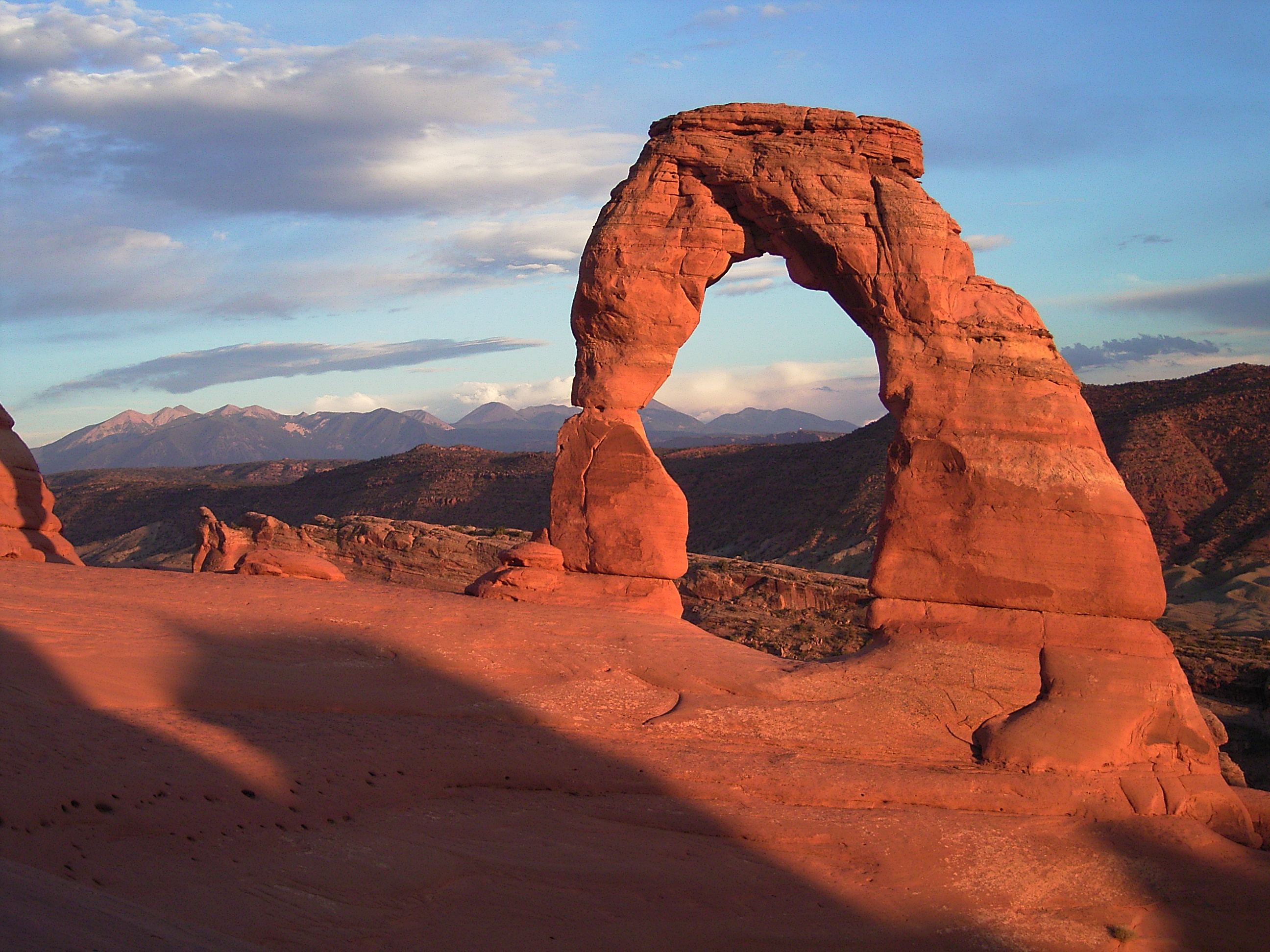
Delicate Arch earns its fame. The 52-foot span balances on the edge of a sandstone bowl, framing the La Sal Mountains when approached from the trail that winds 1.5 miles and 480 vertical feet from the parking area. At sunset, photographers jostle for position as the arch glows blood-red against deepening blue sky. But the park contains multitudes. Double Arch - two spans sharing a common base - towers in a natural amphitheater. Landscape Arch stretches impossibly thin across a 306-foot gap. Turret Arch, Window Arch, Pine Tree Arch, Partition Arch - each offers a different expression of the same geological forces. Some require hikes; others are visible from the road. All remind visitors that nature has been working on these formations far longer than humans have been around to name them.
Living Crust
Between the arches, the desert floor hides a living community in plain sight. Cryptobiotic soil - a dark, knobby crust covering much of the ground - represents decades of growth by cyanobacteria, lichens, mosses, and fungi. This biological soil crust prevents erosion, fixes nitrogen, and creates conditions that allow desert plants to take root. A single footprint can destroy decades of growth; the damage remains visible for years. Signs throughout the park urge visitors to stay on trails and slickrock, and rangers can issue fines for violations. The message extends beyond Arches: across the Southwest's high desert, cryptobiotic crust performs essential ecological functions, and its widespread destruction by off-trail travel represents one of the region's most pervasive environmental threats.
The Moab Gateway
Arches sits just five miles north of Moab, a former uranium mining town reinvented as an adventure tourism hub. Mountain biking, river running, rock climbing, and four-wheeling draw visitors who often combine Arches with nearby Canyonlands National Park and Dead Horse Point State Park. The combination makes Moab one of the busiest outdoor destinations in the American West. Arches feels the pressure: parking lots fill by mid-morning in peak season, timed entry reservations have been implemented, and the hike to Delicate Arch sometimes resembles a pilgrimage more than a wilderness experience. Yet the park's popularity testifies to its power. These arches - improbable, beautiful, ephemeral on geological time scales - draw something close to reverence from visitors who stand beneath them and consider how much patience it takes to make such things.
Desert Extremes
Arches shares the Colorado Plateau's demanding climate. Summer temperatures routinely exceed 100 degrees Fahrenheit, making midday hiking inadvisable and dehydration a genuine danger. Late summer monsoons bring violent thunderstorms that can produce flash floods in normally dry washes - a danger that applies anywhere in canyon country. Spring and fall offer the most comfortable conditions, with daytime highs in the 60s and 70s. Winter brings fewer crowds and occasional snow that dusts the red rock in white, though nights can drop well below freezing. At any season, the desert demands respect: carry more water than you think you need, wear sun protection, check weather forecasts, and remember that the sandstone formations that draw crowds are also inherently unstable. Every year, rescue teams respond to visitors who underestimated the environment or overestimated their abilities.
From the Air
Located at 38.72°N, 109.59°W in southeastern Utah's Canyon Country, near the town of Moab. The park's red rock formations and numerous arches are visible from altitude as distinctive geological features amid the slickrock landscape. The park covers about 76,000 acres. Canyonlands Field (CNY) in Moab offers limited commercial service; Grand Junction Regional (GJT) is 110nm northwest. The Colorado River flows along the park's southern boundary. Best approached in clear conditions when the contrast between red rock and blue sky is most dramatic.