Argentine Declaration of Independence
It was not called Argentina yet. On July 9, 1816, the document that thirty-three deputies signed in a rented house in San Miguel de Tucuman declared the independence not of a country with that name, but of the "United Provinces of South America" -- a title that reveals how uncertain the borders, the identity, and even the form of government of this new nation still were. Several of the signatories represented provinces that would eventually become Bolivia. Others represented territories that wanted nothing to do with the Congress and refused to send delegates at all. The declaration was an act of political will performed in the teeth of military threat, internal division, and the very real possibility of failure.
Napoleon's Unintended Gift
The chain of events that led to Tucuman began not in South America but in Europe. In 1808, Napoleon forced the abdication of Spain's King Ferdinand VII, shattering the legal framework that bound the American colonies to the Spanish Crown. The 1810 May Revolution in Buenos Aires seized on this rupture, replacing the Viceroy with the Primera Junta and beginning six years of war, political improvisation, and fierce argument over what should replace colonial rule. By 1814, Ferdinand VII was back on the Spanish throne and determined to reassert control. Royalist armies had won decisive victories at Huaqui, Vilcapugio, Ayohuma, and Sipe-Sipe in Upper Peru, threatening to roll south into the heart of the revolution. The need for a formal declaration -- something that would transform a murky rebellion into a recognized sovereign act -- grew urgent.
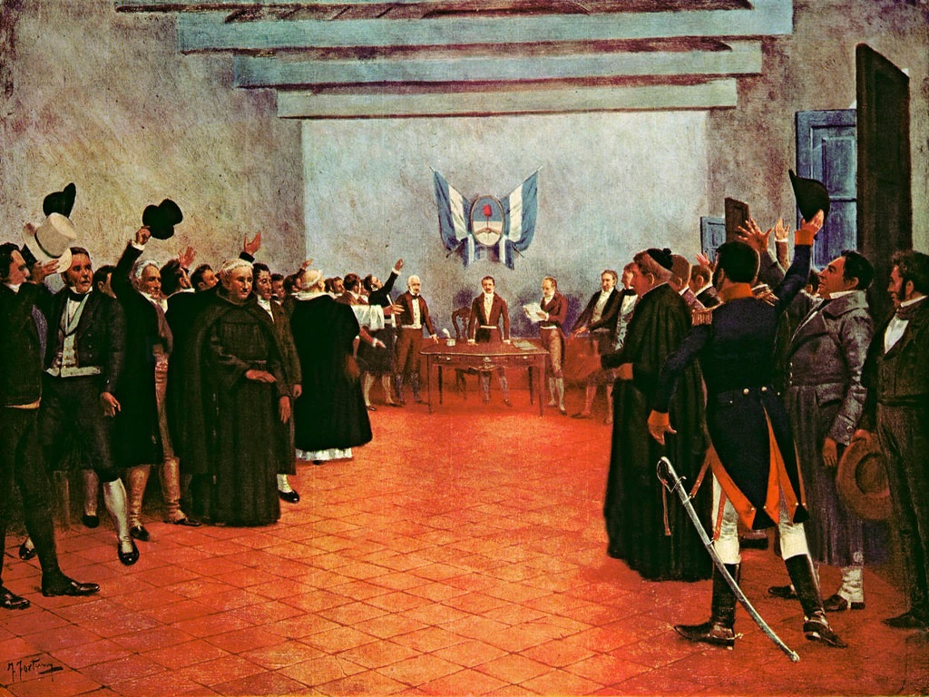
Thirty-Three Deputies in a Borrowed Room
The Congress convened in Tucuman on March 24, 1816, deliberately far from Buenos Aires and its political intrigues. Each deputy represented roughly 14,000 inhabitants, though the Federal League provinces -- Santa Fe, Entre Ríos, Corrientes, Misiones, and the Eastern Province that would become Uruguay -- boycotted the proceedings entirely. What remained was still broadly representative: delegates from Buenos Aires sat alongside those from Jujuy, Mendoza, Cordoba, and several provinces of Upper Peru. The presidency rotated monthly, and the Congress was free to choose its own agenda, a freedom that produced weeks of inconclusive debate. Francisco Narciso de Laprida, the delegate from San Juan, held the presidency when the vote finally came. On July 9, after months of deliberation, the deputies voted to sever all ties with the Spanish Crown, asserting that sovereignty had reverted to the people when Ferdinand VII was deposed in 1808.
Written in Three Languages
The declaration was drafted in Spanish, but the Congress ordered it translated into Quechua and Aymara -- the indigenous languages spoken by millions across the former colonial territory. The Aymara translation is attributed to Vicente Pazos Kanki, a journalist and diplomat of Aymara descent born in 1779. The gesture was partly pragmatic: the revolution needed support from indigenous populations who did not speak Spanish. But it also hinted at an aspiration, however imperfectly realized, that this new nation might belong to all the peoples within its borders. The legal argument embedded in the text was sophisticated: since the Crown of Castile had lost its sovereign when Ferdinand was deposed, the bonds between Spain and its American territories had dissolved. This was the same reasoning invoked by Venezuela in 1811 and Mexico in 1810, a shared constitutional logic uniting independence movements across a continent.
A Nation Still Taking Shape
Independence was declared, but unity proved far harder. The Congress continued working in Buenos Aires from 1817, attempting to define the new state's form of government. Unitarians favored centralized power; Federales demanded provincial autonomy. The tension exploded at the Battle of Cepeda in 1820, which dissolved the Congress and plunged the country into decades of civil conflict. International recognition arrived slowly. The Kingdom of Hawaii recognized Argentine independence in 1818, followed by Portugal in 1821 and the United States in 1822. Spain itself did not acknowledge the loss of its colony until 1857 -- more than four decades after the fact. The house where the declaration was signed, nearly destroyed by Tucuman's humid climate, was nationalized in 1874, partially demolished, and eventually reconstructed in the 1940s from the only surviving photograph, taken in 1869. Today it stands as the Casa de Tucuman, a museum where each July 9 the president of Argentina travels to the city that, for one afternoon in 1816, was the capital of a nation that did not yet know its own name.
From the Air
Located at 26.83°S, 65.20°W in the city of San Miguel de Tucuman, the site of the declaration is now the Casa de Tucuman museum on Calle Congreso. The nearest airport is Teniente Benjamín Matienzo International Airport (SANT), 9 km east of the city. From altitude, the city's grid pattern is visible in the flat terrain east of the Andean foothills. The Aconquija range rises to the west, providing a dramatic backdrop.