Arica
Arica almost never sees rain. The city sits at the edge of the Atacama Desert, where annual precipitation ranks among the lowest recorded anywhere on the planet, and the sky is so reliably clear that locals simply call it the 'city of eternal spring.' Yet this is no desolate outpost. A seaside resort of roughly 260,000 people lines the northern Chilean coast, its beaches drawing Bolivian vacationers who descend from the landlocked altiplano, its streets busy with cross-border traffic from Tacna, Peru, just two hours south. Arica is a city defined by the borders it sits between -- geographic, national, and cultural.
A Port Traded Between Nations
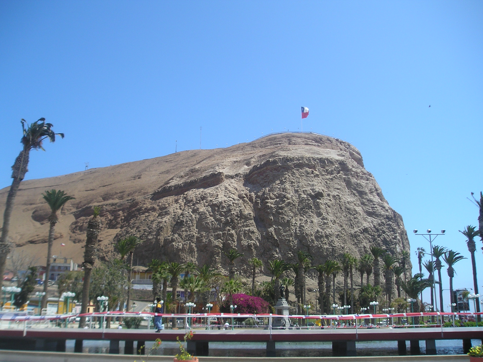
For most of its colonial history, Arica belonged to Peru. The Spanish recognized its natural harbor early, making it an important Pacific port for shipping silver from the mines of Potosi. That strategic value made it a prize in the War of the Pacific, the conflict that reshaped South America's western coast between 1879 and 1884. Chile seized Arica in 1880 during a battle centered on El Morro, the distinctive headland that still towers over the city. Peru did not formally recognize Chilean sovereignty until 1929, nearly half a century later. The transfer left cultural traces that persist: Arica maintains unusually strong ties with Tacna across the Peruvian border, with daily cross-border commuters, shared family networks, and a practical commerce driven by price differences -- Peruvian dental work, for instance, draws Chilean patients south.
The Fog They Call Camanchaca
Despite its reputation for perpetual sunshine, Arica knows a particular kind of darkness. The camanchaca is a dense coastal fog that rolls in from the Pacific, created when the cold Humboldt Current chills the marine air layer until moisture condenses into a thick, low blanket. It can dim the sky for hours, softening the edges of buildings and muffling the sounds of the port. In the nearby Atacama, camanchaca is the primary source of moisture for fog-catching plants and the lomas -- isolated fog oases where vegetation clusters around hilltops that intercept the mist. The phenomenon gives Arica a dual personality: a sun-drenched resort that periodically retreats into grey stillness, as though the desert itself were pausing to breathe.
Roots in the Azapa Valley
A few kilometers inland, the Azapa Valley cuts through the coastal desert like a green incision. Fed by river water channeled through irrigation, the valley produces vegetables and the region's distinctive Azapa olives, cultivated here since colonial times. The valley is also home to some of the oldest archaeological evidence of human habitation in the Americas -- the Chinchorro culture, whose people practiced mummification thousands of years before the Egyptians. A substantial community of African Chileans traces its roots to Arica and the Azapa Valley, descendants of enslaved Africans brought to work in the colonial economy. Their cultural contributions -- music, dance, cuisine -- form a layer of Arica's identity that is often overlooked in narratives focused on the city's Chilean-Peruvian duality.
Crossroads of Three Nations
Arica functions as a hinge connecting Chile, Peru, and Bolivia. Separate railway lines run to Tacna and to La Paz, the latter climbing from sea level to the Altiplano in a journey that crosses one of the most dramatic elevation changes accessible by rail. The international bus terminal handles daily services from La Paz, Cochabamba, and Oruro, while colectivos -- shared taxis -- shuttle passengers to and from Tacna throughout the day. Bolivia, landlocked since losing its coastal territory in the War of the Pacific, depends on Arica's port for Pacific access, a political arrangement that remains a source of diplomatic tension. The city's role as a tri-national junction gives it a cosmopolitan energy unusual for its size, with Quechua and Aymara heard alongside Spanish in the markets.
Surf, Sand, and the Shadow of El Morro
El Morro de Arica dominates the city's skyline -- a steep, rocky headland that served as the site of the decisive 1880 battle and now functions as a geographic landmark visible from virtually everywhere in town. North of El Morro, sandy beaches stretch along the coast, warm enough for swimming in summer and empty enough in winter to feel private. South of the headland, the waves steepen, attracting surfers who ride breaks that rank among the best in northern Chile. Inland, the road climbs toward Lauca National Park, where Chungara Lake sits at 4,500 meters surrounded by volcanoes. The park's high-altitude wetlands and herds of vicunas feel like a different planet from the sun-soaked beaches below, yet both landscapes fall within a few hours' drive of a city that somehow bridges desert and ocean, lowland and altiplano.
From the Air
Arica sits at 18.48°S, 70.32°W on Chile's northernmost coast, where the Atacama Desert meets the Pacific Ocean. El Morro, a prominent headland, is a clear visual landmark from the air. Chacalluta International Airport (SCAR) serves the city, located near the Peruvian border. The Azapa Valley is visible as a green ribbon running inland from the coast. The Peruvian border and Tacna lie approximately 50 km to the south. To the east, terrain climbs dramatically toward the Altiplano and Lauca National Park. Skies are almost always clear with minimal precipitation.