Arribes del Duero Natural Park
In late February, the almond trees of Mieza burst into white and pink blossom. This would be unremarkable in Andalusia, but Mieza sits in the province of Salamanca, deep in the continental interior of Castile and Leon, where winter temperatures routinely drop below freezing. The almonds can grow here because the Duero River, in the process of carving the deepest gorges in Spain, created a sheltered microclimate hundreds of meters below the surrounding plateau. The Arribes del Duero Natural Park protects 1,061 square kilometers of this improbable landscape, where Mediterranean warmth hides inside granite canyons on the Spanish-Portuguese border.
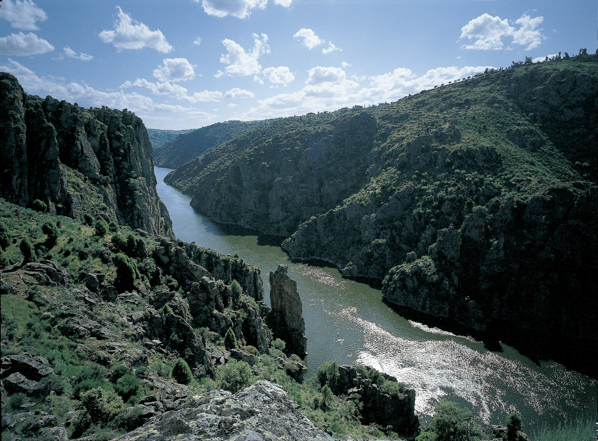
The Gorge That Swallowed a Plateau
The word arribes comes from the local dialect, meaning steep cliffs or precipices, and the name is no exaggeration. Over millions of years, the Duero and its tributaries have cut granite gorges reaching depths of 400 to 500 meters, the deepest river canyons on the Iberian Peninsula. Standing at the rim, the plateau stretches flat and austere in every direction, giving no hint of what lies below. Then the ground drops away, and the landscape transforms. The canyon walls plunge to the river in a series of terraces and vertical faces, each layer exposing a different chapter of geological history. The Duero here forms the national boundary between Spain and Portugal, with the Portuguese Douro International Natural Park protecting the opposite bank.
A Hidden Mediterranean
The depth of the gorge does more than create dramatic scenery. It traps warmth. While the plateau above endures the harsh continental climate of Castile, with freezing winters and scorching summers, the sheltered canyon bottoms enjoy a Mediterranean microclimate with milder temperatures and reduced frost. Farmers recognized this centuries ago, building terraces on the slopes to cultivate olive trees, almond groves, cherry orchards, and vineyards at latitudes where these crops should not thrive. The almond forest near Mieza is reputed to be the largest in Europe. Riverside vegetation of ash and willow softens the canyon floor, while the terraced hillsides above create a patchwork of cultivation that has changed little in centuries.
Wings Over the Canyon
The European Union designated the Arribes del Duero a Special Protection Area for good reason. Over 300 bird species have been recorded here. Black storks, among the most emblematic, nest on the cliff ledges. Griffon vultures and Egyptian vultures ride the thermals that rise from the sun-warmed rock. Golden eagles and Bonelli's eagles patrol the canyon. Eagle owls hunt at dusk. Red and black kites circle above the terraces. Peregrine falcons and lesser kestrels occupy their own niches in the vertical world. On the ground, the park shelters Iberian wolves and, in the remoter sections, the Iberian lynx. The combination of vertical cliff habitat, sheltered microclimate, and low human disturbance makes the arribes one of the richest wildlife corridors in Western Europe.
Stone Villages Above the Void
Human settlement here has always been shaped by the gorge. Villages like Aldeadavila de la Ribera and Villarino de los Aires perch on the canyon rim, their granite houses looking out over a void that drops hundreds of meters to the river below. The communities developed in relative isolation, connected by narrow roads that wind through the plateau and rarely descend to the water. The Duero itself was navigable only with difficulty in this section, its current channeled between rock walls. A series of hydroelectric dams built in the 20th century tamed some of the river's force and created reservoirs that now offer boat excursions through the canyon. But the fundamental character of the landscape remains unchanged: a flat, dry meseta suddenly ripped open to reveal a hidden world of warmth, water, and life.
From the Air
Located at 41.32N, 6.40W in western Castile and Leon, Spain, along the Portuguese border. The park is spectacularly visible from the air as deep canyon incisions in an otherwise flat meseta landscape. The contrast between plateau and gorge floor is dramatic. Nearest airport is LESA (Salamanca) approximately 100 km southeast. LPBG (Braganca, Portugal) lies approximately 120 km north. Best viewed from 4,000-6,000 ft AGL. The hydroelectric reservoirs in the canyon provide useful visual references. The Spanish and Portuguese protected areas together form a continuous corridor along the river.