The Astoria Column: 525 Feet of History Wrapped Around Concrete
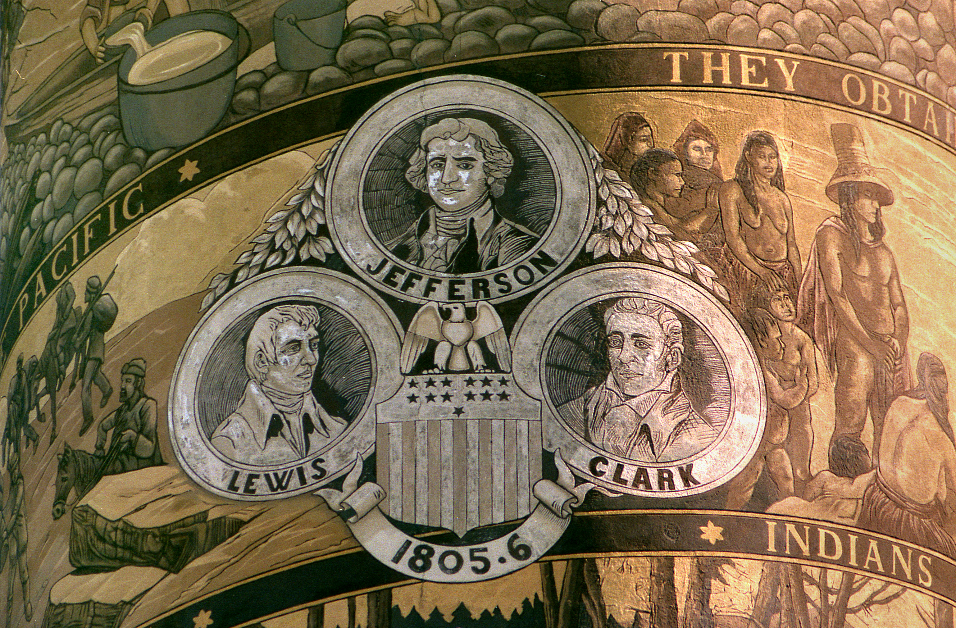
Climb 164 steps inside a concrete tower on the highest point in Astoria, and the entire mouth of the Columbia River spreads below you. But before you reach the observation deck, look at the outside. A spiral frieze wraps the column's full height - 525 feet of narrative carved in sgraffito technique, depicting Captain Gray's 1792 discovery of the Columbia, Lewis and Clark's arrival, and twelve other scenes from Oregon's founding. The Astoria Column, dedicated on July 22, 1926, was patterned after Trajan's Column in Rome, a choice that says everything about how Astoria saw itself in the 1920s: as a place where empires began.
An Astor Pays His Respects
The column exists because two powerful interests converged on one hilltop. Vincent Astor, great-grandson of John Jacob Astor - the fur magnate who founded Fort Astoria in 1811 as America's first permanent Pacific settlement - helped finance the monument. So did the Great Northern Railway, which had its own reasons for commemorating the region's history: railroads sold the West by romanticizing it. Together they funded a tower that would anchor a 30-acre city park on Coxcomb Hill, 600 feet above the Columbia. The dedication ceremony drew crowds who understood the symbolism - the Astor family returning to honor the settlement their ancestor had started and then, during the War of 1812, nearly lost to the British. It was an act of reclamation as much as commemoration.
Reading the Spiral
The frieze is the column's soul. Nearly seven feet wide and wrapping 525 feet around the exterior, the sgraffito mural illustrates 14 significant events in Oregon's early history alongside 18 scenes from the broader region. The technique - scratching through a layer of plaster to reveal contrasting color beneath - gives the images a textured, almost carved quality that photographs rarely capture. Captain Robert Gray sailing into the Columbia in 1792. The Lewis and Clark Expedition reaching the Pacific. The founding of Fort Astoria. The arrival of settlers. Each scene flows into the next as the viewer's eye spirals upward, transforming the column into a vertical timeline. At the top, a replica of the State Seal of Oregon caps the narrative. The murals were refurbished in 1995 after decades of Pacific Northwest weather had softened their edges, and a granite plaza added in 2004 gave visitors a proper place to stand and look up.
Rome on the Columbia
Modeling the column after Trajan's Column in Rome - with a nod to the Place Vendome Column in Paris - was audacious. Trajan's Column commemorated a Roman emperor's military victories in Dacia; the Astoria Column commemorated fur traders, explorers, and settlers on the edge of a continent. But the parallel was intentional. In the 1920s, the Pacific Northwest was still constructing its mythology, finding its place in the national story. A Roman-style monument declared that what happened at the Columbia's mouth mattered - that American history didn't only flow from Philadelphia and Plymouth Rock but also from the fog and rain of the Oregon coast. The column was listed on the National Register of Historic Places in 1974, official recognition that the monument had itself become historical.
The Climb Today
The cast-iron spiral staircase inside the column was closed for safety in November 2007 and reopened in August 2009, in time for Astoria's annual Regatta. Those 164 steps remain the only way to reach the observation deck - there is no elevator, no shortcut. The climb is part of the experience: the interior narrows as you ascend, the iron steps ringing under your feet, until you emerge onto the deck and the view opens in every direction. The Columbia stretches toward the Pacific, the Astoria-Megler Bridge spans the river's width, and the Coast Range rises behind the town. On clear days, visitors throw balsa-wood gliders from the top, watching them catch thermals and spiral down toward the park below. It is one of the few monuments in the American West that rewards both its exterior study and the physical effort of getting to its top.
From the Air
Located at 46.181N, 123.818W atop Coxcomb Hill (600 feet elevation) in Astoria, Oregon. The column stands 125 feet tall, making its tip roughly 725 feet above sea level - a prominent landmark visible from considerable distance. The tower sits within the 30-acre Astor Park. From the air, it appears as a slender white pillar on the highest point in the city. The Columbia River mouth dominates the landscape to the north and west, with the Astoria-Megler Bridge crossing to Washington. Nearest airport: Astoria Regional Airport (KAST), approximately 3 miles southeast. Best viewed at 1,500-2,500 feet for the column's context against the city and river. The river bar where the Columbia meets the Pacific is visible to the west.