Atlantic Ocean Road
Twelve hurricanes struck during construction. That fact alone tells you what kind of road this is. The Atlantic Ocean Road -- Atlanterhavsveien in Norwegian -- runs 8.3 kilometers across an archipelago on the coast of More og Romsdal county, hopping between small islands and skerries on eight bridges, several causeways, and a series of viaducts that seem to dare the Norwegian Sea to swallow them. Opened on July 7, 1989, the road connects the island of Averoya with the mainland, threading through Hustadvika -- one of the most exposed stretches of the Norwegian coast. In 2006, The Guardian declared it the best road trip in the world. The automotive industry agreed: more than ten car manufacturers have filmed television commercials along the route, usually showcasing the weather at its most theatrical.
A Railway That Became a Road
The route was first imagined as a railway. In the early twentieth century, as the Rauma Line was being planned to connect More og Romsdal to Norway's national rail network, proposals emerged to extend it along the coast. In 1921 the county council chose an outer route that would have followed roughly the same path the road takes today. But the Rauma Line was never built beyond Andalsnes, and by 1935 the Norwegian Parliament decided that roads, not rails, would link the coastal towns. The idea lay dormant for decades until locals revived it. A toll company, Atlanterhavsveien AS, was established in 1970. In the early 1980s, Minister of Local Government Arne Rettedal proposed directing job creation funds toward road projects. Three municipalities threw their support behind the plan, and construction began on August 1, 1983.
Building Through the Storms
Progress was slow at first. The project started as a municipal road effort, but from July 1, 1986, the Norwegian Public Roads Administration took over, accelerating construction through conditions that would have stopped most projects cold. Workers endured twelve major windstorms over the six years of construction, battling waves and gales on exposed skerries where there was often nowhere to shelter. The cost was financed through a mix of tolls, job creation funds, and state road grants -- twenty-five percent from each of the first two sources, fifty percent from the state. When the road opened on July 7, 1989, it replaced the Tovik-Orjavik ferry and gave Averoya its first fixed link to the mainland. Toll collection was scheduled for fifteen years, but the road proved so popular that it was paid off by June 1999, five years ahead of schedule.
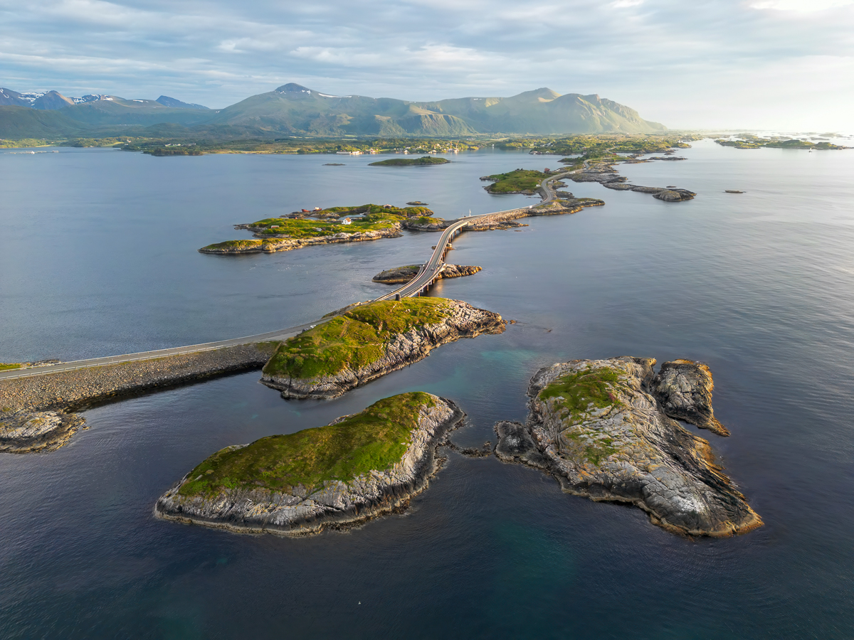
Island to Island
Driving the road from Averoya, you begin at Utheim near the village of Karvag and immediately enter a landscape where the distinction between land and sea becomes academic. The road leaps onto Kuholmen, crosses the 115-meter Little Lauvoeysund Bridge to Lille Lauvoy, then continues across Store Lauvholmen Bridge to Store Lauvoy. Geitoysund Bridge carries you to Geitoya, where a viewpoint lets you pause and absorb the scale of what surrounds you. The road then threads across Eldhusoya, Lyngholmen, and Ildhusoya before reaching the centerpiece: Storseisundet Bridge, a 260-meter cantilever span that arcs dramatically over the water. Beyond it lie Flatskjaeret, the three Hulvagen Bridges at a combined 293 meters, and the islands of Skarvoy and Stromsholmen before the 119-meter Vevangstraumen Bridge delivers you back to the mainland.
Construction of the Century
Recognition has accumulated steadily. The Norwegian construction industry named the Atlantic Ocean Road the "Norwegian Construction of the Century" in 2005. The Norwegian Directorate for Cultural Heritage preserved it as a cultural heritage site in December 2009 -- an unusual distinction for a road barely two decades old. That same month, the Atlantic Ocean Tunnel opened between Averoya and Kristiansund, creating a fixed link between Kristiansund and Molde when combined with the road. Along with the stretch from Vevang to the village of Bud, the route is designated one of eighteen National Tourist Routes in Norway. In 2009, it was the country's ninth-most-visited natural attraction, drawing 258,654 visitors between May and August alone. The road has become something more than infrastructure: it is a destination in itself, a place where driving is the point rather than the means.
From the Air
The Atlantic Ocean Road runs along the coast at approximately 63.02N, 7.35E, connecting Averoya island to the mainland in More og Romsdal county. From the air, the chain of bridges and causeways hopping between small islands is unmistakable -- especially Storseisundet Bridge with its dramatic curved profile. Nearest airports are Molde Airport Aro (ENML) about 50 km east and Kristiansund Airport Kvernberget (ENKB) about 30 km north. Best viewed at 3,000-6,000 ft AGL for the full serpentine layout across the archipelago.