The Dam That California Could Never Finish -- Or Forget
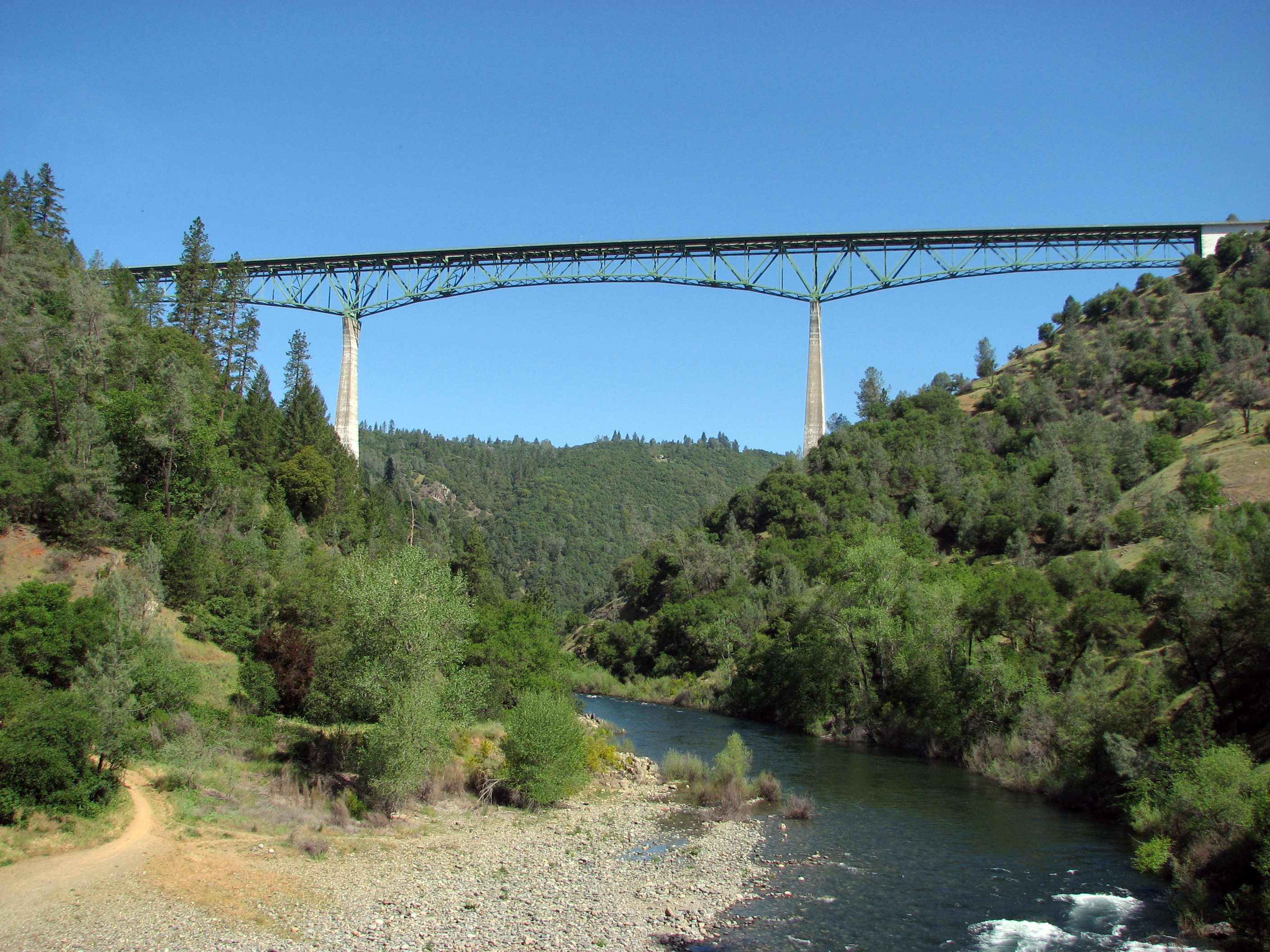
Drive across the Foresthill Bridge east of Auburn, California, and you are 730 feet above the North Fork of the American River -- on a bridge built to span a reservoir that never existed. The bridge was completed in 1973 as part of the Auburn Dam project, a Bureau of Reclamation plan to build what would have been the tallest concrete dam in the state at 680 feet. Construction began in 1968. Workers diverted the river through a tunnel, excavated the canyon walls, and poured the foundations of a cofferdam. Then, in 1975, an earthquake near Oroville changed everything. The dam was never finished. But it was never quite abandoned, either.
The Grand Design
The Auburn Dam was conceived as the centerpiece of the Auburn-Folsom South Unit of the Central Valley Project, authorized by Congress in the 1960s. The plan was ambitious: a thin-arch concrete dam on the North Fork of the American River, straddling the border of Placer and El Dorado Counties. At 680 feet, it would have impounded 2.3 million acre-feet of water, creating a reservoir stretching deep into the Sierra foothills. The dam was to serve multiple purposes -- flood control for Sacramento, hydroelectric power generation, irrigation supply for the Central Valley, and municipal water for a rapidly growing region. Construction began in earnest in 1968, with workers boring a diversion tunnel to reroute the river and beginning the massive excavation of the dam's foundation. Roads through the site were relocated, including a stretch of California State Route 49. The Foresthill Bridge, rising 730 feet above the canyon floor, was completed to carry traffic over what would become the reservoir.
The Earthquake That Stopped Everything
On August 1, 1975, a magnitude 5.7 earthquake struck near Oroville Dam, roughly fifty miles northwest of the Auburn site. The Oroville Dam itself -- a massive earthfill structure completed in 1968 -- was undamaged. But geologists began asking uncomfortable questions. The quake appeared to be reservoir-induced: the sheer weight of Lake Oroville's water was pressing down on underlying fault zones, generating enough stress to trigger seismic events. If a filled reservoir could cause an earthquake at Oroville, what might happen at Auburn? The proposed thin-arch design was particularly vulnerable to seismic forces. The Bureau of Reclamation halted major construction in 1977 to reevaluate the site's geology. Engineers found previously unrecognized faults running through the canyon. The project stalled, then froze. Hundreds of millions of dollars had already been spent on excavation, the diversion tunnel, the cofferdam, the bridge, and road relocations. The hole in the canyon remained.
The Dam That Would Not Die
For decades afterward, Auburn Dam refused to leave the political conversation. Congressman John Doolittle became its most persistent champion, appropriating millions for feasibility studies and seismic evaluations. After Hurricane Katrina in 2005, he argued that Sacramento faced similar flood vulnerability, pointing to the limitations of the existing Folsom Dam as proof that Auburn was still needed. Supporters at the Sacramento County Taxpayers' League reported in 2011 that two-thirds of Sacramento residents still supported building the dam. Pro-dam groups eventually pivoted to a "dry dam" concept -- a structure that would stand empty most of the year, impounding floodwaters only during extreme events for days or weeks before releasing them. This approach would preserve the American River canyons while still protecting Sacramento against a 500-year flood. It would also allow Folsom Lake to be kept at higher levels year-round, improving recreation and groundwater recharge in a region where the aquifer was severely depleted.
Alternatives Win Out
While dam advocates lobbied, the federal government invested in other solutions. The US$1 billion Joint Federal Project at Folsom Dam, a collaboration between the Bureau of Reclamation and the Army Corps of Engineers, added a new lower spillway and reinforced the eight dikes that help contain the reservoir. Key levees along the lower American River were strengthened. A pumping station built in 2006 on the Middle Fork American River supplied 100 cubic feet per second to the Placer County Water Agency through a new pipeline, eliminating one of the arguments for Auburn Dam's water supply function. The Sacramento Municipal Utility District had already decommissioned its Rancho Seco nuclear plant in 1989, removing a major water consumer. The Freeport Project, which came online in 2011, redirected water supplies from the Sacramento River, further reducing the need for additional American River storage.
A River Runs Through It Again
By 2006, the Bureau of Reclamation began restoring the dam site itself. The river diversion tunnel was sealed. The remnants of the cofferdam and construction debris were excavated from the canyon. Workers leveled and graded the riverbed, then built an artificial channel with Class III rapids to guide the North Fork American River through the site where the dam's foundation had been prepared nearly four decades earlier. Recreational amenities were added around the restored canyon. The act was widely interpreted as the final step: the federal government was decommissioning the Auburn Dam project and shelving it permanently. Today, the canyon runs free. Kayakers paddle the manufactured rapids where concrete was supposed to rise. The Foresthill Bridge still arches overhead, California's tallest bridge, carrying commuters and sightseers over a valley that was supposed to be underwater. It is a monument to the plan that almost was -- and to the earthquake, the faults, and the slow accumulation of alternatives that kept it from ever happening.
From the Air
The Auburn Dam site is located at 38.88N, 121.06W on the North Fork of the American River, east of the city of Auburn in Placer County. The Foresthill Bridge, spanning the canyon at 730 feet, is the most prominent visual landmark and is clearly visible from altitude. The deep canyon of the North Fork cuts through the Sierra Nevada foothills below. Auburn Municipal Airport (KAUN) lies approximately 3nm to the west. Sacramento Executive (KSAC) is about 30nm southwest. Folsom Lake and Folsom Dam are visible downstream to the southwest. The Sierra Nevada crest and its snowfields stretch along the eastern horizon.