Auckland Harbour Bridge
The bridge was supposed to have six lanes. It opened in 1959 with four. By 1965, annual traffic was three times the original forecast, and the decision to cut two lanes for budget reasons had become what one commentator called 'a ringing testament to the peril of short-term thinking and penny-pinching.' Auckland has been paying for that choice ever since, bolting on clip-on extensions, arguing for decades over whether pedestrians and cyclists deserve a crossing, and watching 170,000 vehicles a day squeeze across a structure designed for a North Shore population of 50,000.
A Hundred Years of Trying
The idea of bridging the Waitematā Harbour is older than most Aucklanders realize. In 1860, engineer Fred Bell proposed a floating pontoon crossing for North Shore farmers who wanted to herd animals to market, but the scheme collapsed under a cost estimate of 16,000 pounds. Two Royal Commissions, in 1930 and 1946, studied the viability of a bridge. It was not until the 1950s that construction finally began. The North Shore at that point was a mostly rural area with few jobs and a growth rate half that of Auckland south of the harbour. The bridge was meant to unlock expansion, and in that narrow sense it succeeded spectacularly, transforming the shore from pastoral fringe into a sprawl of suburbs that now sends rivers of commuter traffic back across the water every morning.
Tugboat Against the Storm
Construction was a feat of improvisation. Large steel girder sections were partially assembled onshore, then floated into position on barges. During one operation, stormy weather set a barge drifting with a main span aboard. The tugboat William C Daldy fought a 36-hour battle against high winds to keep the section from being lost. The bridge was built from opposing sides of the harbour, the southern section cantilevered outward until the two halves joined in March 1959. The hollow girder design by Freeman, Fox and Partners was unprecedented in New Zealand, falling outside the country's 1950s building codes. On 30 May 1959, Governor-General Lord Cobham officially opened the crossing. An open day had drawn 106,000 people to walk across, a number the bridge would rarely see on foot again.
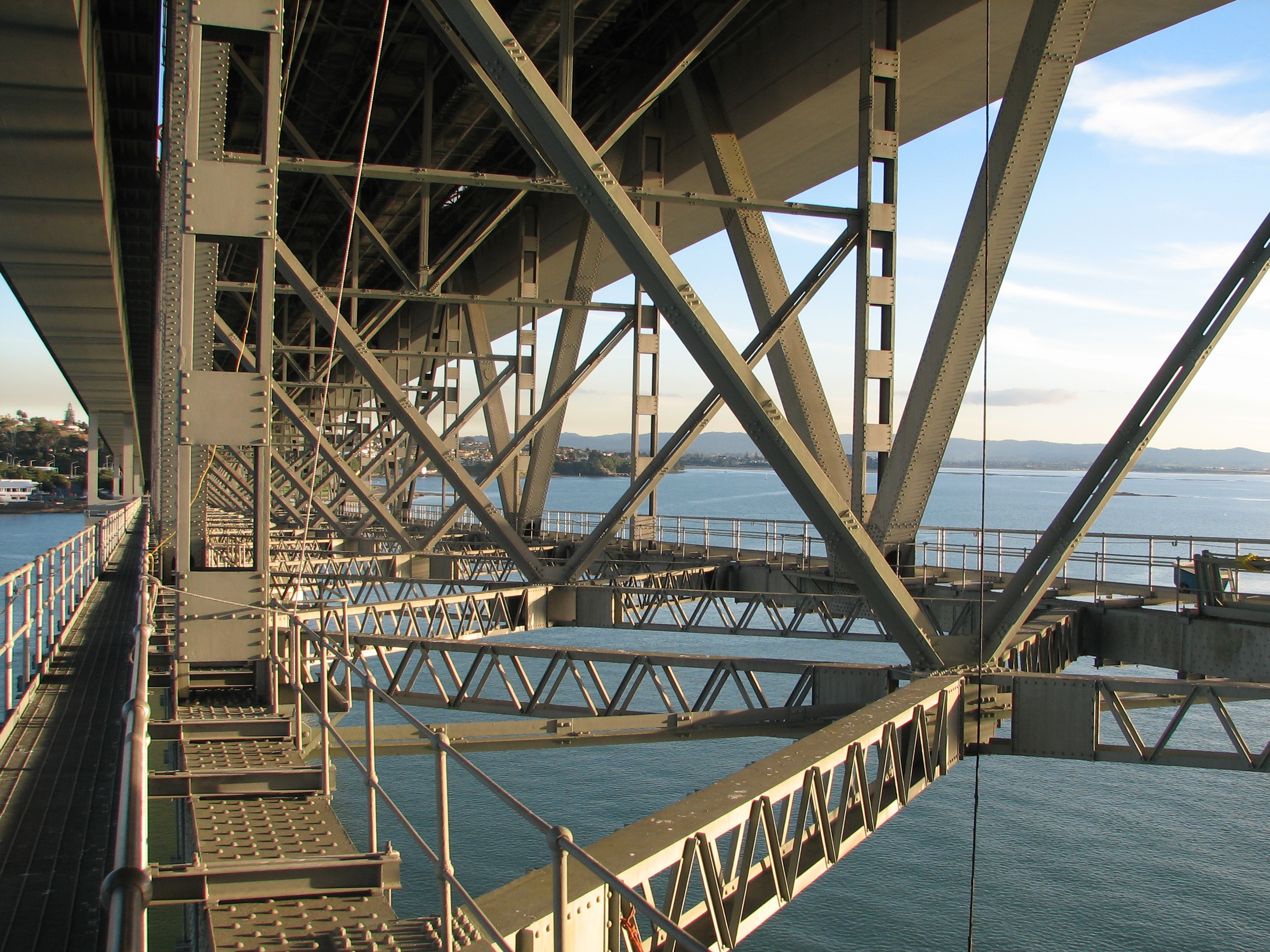
The Nippon Clip-Ons
With four lanes overwhelmed, the government commissioned two additional lanes on each side in 1968-1969. The extensions were manufactured by a Japanese company, earning the nickname 'Nippon clip-ons,' a choice considered bold barely twenty years after the Second World War. The clip-ons are of orthotropic box structure, extending as cantilevers from the original piers, and they cost far more than the extra lanes would have if included from the start. Their long-term structural health has been a persistent concern. A 2006 report from Beca Group warned of catastrophic failure risk if heavy trucks stalled in a traffic jam on the clip-on lanes. Maintenance costs ballooned from an initial 45 million New Zealand dollars to over 86 million as engineers discovered the reinforcing task was nearly double what they had estimated.
The Bridge That Won't Share
Rail lines and walking paths were dropped from the original design to save money, and restoring them has proven almost impossible. A proposed cycleway called SkyPath received council funding approval and planning consent in 2016 but was never built. In 2021, the government announced a separate walking and cycling bridge at an estimated cost of 785 million dollars, then scrapped it months later after spending 51 million on designs and consultants. Protesters have twice surged onto the bridge on foot, in 2009 and again in 2021, when 1,500 cyclists pushed past a police cordon. A moveable concrete barrier, installed in 1990 to prevent head-on collisions, now shifts one lane four times daily at 6 kilometres per hour, the first such system on a box girder bridge in the world. The bridge carries nearly 170,000 vehicles per day, but to this day, not a single sanctioned pedestrian crossing exists.
Luminous and Fragile
Since November 2017, LED lights powered by renewable energy have turned the bridge into a coloured ribbon across the harbour at night, an installation by utility company Vector Limited. AJ Hackett operates a bungy jump and guided climb over the arch truss. But the bridge's vulnerabilities are real. In September 2020, gusts up to 127 kilometres per hour caused a truck to strike a main diagonal truss member, shutting down lanes for weeks until a permanent strut was installed. Since that incident, the bridge has been closed 20 times, costing over 35.6 million dollars in economic damage. The 2024 Baltimore Key Bridge collapse prompted a safety review, which classified vessel collision risk as rare but acknowledged that the Chelsea Sugar Refinery ship is the only cargo vessel that regularly passes beneath. Auckland's harbour bridge, at 65 years old, remains indispensable and irreplaceable, the single thread connecting a city to its northern half.
From the Air
Located at 36.829°S, 174.746°E, spanning Waitematā Harbour. The 1,020 m bridge is clearly visible connecting the CBD (St Marys Bay) to the North Shore (Northcote). Main span rises 43 m above high water. The bridge sits northwest of the Sky Tower and is a key visual reference for approaches to Auckland. Recommended viewing altitude: 1,500-3,000 ft for full harbour context. Nearby airports: Auckland International (NZAA), Whenuapai (NZWP) 8 nm northwest, North Shore Aerodrome (NZNE). Note: Vector LED lights make the bridge visible at night.